You are here: Home > Network List > XC91 - Tibetan Plateau Broadband Experiment Stations List
> Station TUNL XC.TUNL > Earthquake Result Viewer
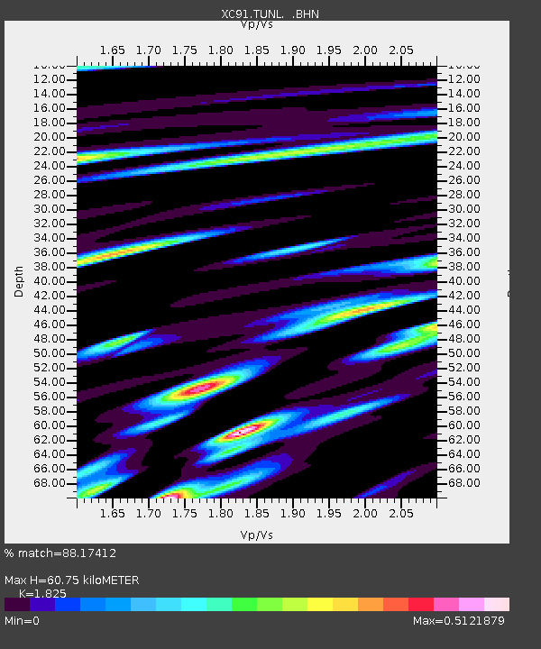
TUNL XC.TUNL - Earthquake Result Viewer
| Earthquake location: |
Hokkaido, Japan Region |
| Earthquake latitude/longitude: |
45.6/142.3 |
| Earthquake time(UTC): |
1992/06/16 (168) 05:51:04 GMT |
| Earthquake Depth: |
329 km |
| Earthquake Magnitude: |
5.7 MB |
| Earthquake Catalog/Contributor: |
WHDF/NEIC |
|
| Network: |
XC Tibetan Plateau Broadband Experiment |
| Station: |
TUNL XC.TUNL |
| Lat/Lon: |
36.20 N/94.82 E |
| Elevation: |
3133 m |
|
| Distance: |
36.6 deg |
| Az: |
272.248 deg |
| Baz: |
60.118 deg |
| Ray Param: |
0.07521345 |
| Estimated Moho Depth: |
60.75 km |
| Estimated Crust Vp/Vs: |
1.83 |
| Assumed Crust Vp: |
6.385 km/s |
| Estimated Crust Vs: |
3.499 km/s |
| Estimated Crust Poisson's Ratio: |
0.29 |
|
| Radial Match: |
88.17412 % |
| Radial Bump: |
400 |
| Transverse Match: |
68.41733 % |
| Transverse Bump: |
400 |
| SOD ConfigId: |
23496 |
| Insert Time: |
2010-02-26 15:12:52.506 +0000 |
| GWidth: |
2.5 |
| Max Bumps: |
400 |
| Tol: |
0.001 |
|

Signal To Noise
| Channel | StoN | STA | LTA |
| XC:TUNL: :BHN:19920616T05:57:10.291003Z | 46.067062 | 8.7128706E-7 | 1.8913449E-8 |
| XC:TUNL: :BHE:19920616T05:57:10.291003Z | 38.747974 | 8.730444E-7 | 2.2531356E-8 |
| XC:TUNL: :BHZ:19920616T05:57:10.291003Z | 50.99933 | 1.8457447E-6 | 3.6191548E-8 |
| Arrivals |
| Ps | 8.4 SECOND |
| PpPs | 25 SECOND |
| PsPs/PpSs | 34 SECOND |


