You are here: Home > Network List > GE - GEOFON Stations List
> Station PUL GEOFON Station Pulkovo, Russia > Earthquake Result Viewer
PUL GEOFON Station Pulkovo, Russia - Earthquake Result Viewer
| Earthquake location: |
Myanmar |
| Earthquake latitude/longitude: |
26.9/97.2 |
| Earthquake time(UTC): |
2000/06/07 (159) 21:46:55 GMT |
| Earthquake Depth: |
33 km |
| Earthquake Magnitude: |
6.3 MB, 6.5 MS, 6.4 MW, 6.4 MW |
| Earthquake Catalog/Contributor: |
WHDF/NEIC |
|
| Network: |
GE GEOFON |
| Station: |
PUL GEOFON Station Pulkovo, Russia |
| Lat/Lon: |
59.77 N/30.32 E |
| Elevation: |
65 m |
|
| Distance: |
55.6 deg |
| Az: |
325.658 deg |
| Baz: |
95.191 deg |
| Ray Param: |
0.06461956 |
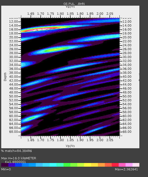
| Estimated Moho Depth: |
16.0 km |
| Estimated Crust Vp/Vs: |
1.68 |
| Assumed Crust Vp: |
6.552 km/s |
| Estimated Crust Vs: |
3.9 km/s |
| Estimated Crust Poisson's Ratio: |
0.23 |
|
| Radial Match: |
94.38496 % |
| Radial Bump: |
400 |
| Transverse Match: |
81.466225 % |
| Transverse Bump: |
400 |
| SOD ConfigId: |
3744 |
| Insert Time: |
2010-03-09 04:16:48.475 +0000 |
| GWidth: |
2.5 |
| Max Bumps: |
400 |
| Tol: |
0.001 |
|

Signal To Noise
| Channel | StoN | STA | LTA |
| GE:PUL: :BHN:20000607T21:55:57.777014Z | 0.9921492 | 4.823553E-7 | 4.8617215E-7 |
| GE:PUL: :BHE:20000607T21:55:57.777014Z | 2.060803 | 1.1830359E-6 | 5.740655E-7 |
| GE:PUL: :BHZ:20000607T21:55:57.777014Z | 4.2391005 | 1.3665863E-6 | 3.2237648E-7 |
| Arrivals |
| Ps | 1.8 SECOND |
| PpPs | 6.2 SECOND |
| PsPs/PpSs | 7.9 SECOND |


