You are here: Home > Network List > GE - GEOFON Stations List
> Station PUL GEOFON Station Pulkovo, Russia > Earthquake Result Viewer
PUL GEOFON Station Pulkovo, Russia - Earthquake Result Viewer
| Earthquake location: |
Tajikistan-Xinjiang Border Reg. |
| Earthquake latitude/longitude: |
38.5/73.4 |
| Earthquake time(UTC): |
2002/04/14 (104) 02:04:21 GMT |
| Earthquake Depth: |
118 km |
| Earthquake Magnitude: |
5.4 MB, 5.5 MW, 5.4 MW |
| Earthquake Catalog/Contributor: |
WHDF/NEIC |
|
| Network: |
GE GEOFON |
| Station: |
PUL GEOFON Station Pulkovo, Russia |
| Lat/Lon: |
59.77 N/30.32 E |
| Elevation: |
65 m |
|
| Distance: |
34.4 deg |
| Az: |
322.296 deg |
| Baz: |
108.579 deg |
| Ray Param: |
0.07737235 |
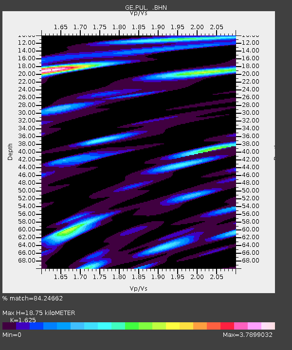
| Estimated Moho Depth: |
18.75 km |
| Estimated Crust Vp/Vs: |
1.62 |
| Assumed Crust Vp: |
6.552 km/s |
| Estimated Crust Vs: |
4.032 km/s |
| Estimated Crust Poisson's Ratio: |
0.20 |
|
| Radial Match: |
84.24662 % |
| Radial Bump: |
400 |
| Transverse Match: |
55.86647 % |
| Transverse Bump: |
400 |
| SOD ConfigId: |
20082 |
| Insert Time: |
2010-03-09 04:17:43.412 +0000 |
| GWidth: |
2.5 |
| Max Bumps: |
400 |
| Tol: |
0.001 |
|

Signal To Noise
| Channel | StoN | STA | LTA |
| GE:PUL: :BHN:20020414T02:10:26.999009Z | 1.8455999 | 7.1606047E-7 | 3.8798254E-7 |
| GE:PUL: :BHE:20020414T02:10:26.999009Z | 4.1741447 | 1.643313E-6 | 3.9368857E-7 |
| GE:PUL: :BHZ:20020414T02:10:26.999009Z | 3.304445 | 9.4251544E-7 | 2.8522655E-7 |
| Arrivals |
| Ps | 2.0 SECOND |
| PpPs | 6.9 SECOND |
| PsPs/PpSs | 8.8 SECOND |


