You are here: Home > Network List > GS - US Geological Survey Networks Stations List
> Station ID05 Sulphur Canyon Road, Soda Springs, Idaho, USA > Earthquake Result Viewer
ID05 Sulphur Canyon Road, Soda Springs, Idaho, USA - Earthquake Result Viewer
| Earthquake location: |
South Of Fiji Islands |
| Earthquake latitude/longitude: |
-23.7/-176.9 |
| Earthquake time(UTC): |
2017/09/26 (269) 04:20:00 GMT |
| Earthquake Depth: |
98 km |
| Earthquake Magnitude: |
6.4 mww |
| Earthquake Catalog/Contributor: |
NEIC PDE/us |
|
| Network: |
GS US Geological Survey Networks |
| Station: |
ID05 Sulphur Canyon Road, Soda Springs, Idaho, USA |
| Lat/Lon: |
42.64 N/111.46 W |
| Elevation: |
2262 m |
|
| Distance: |
89.4 deg |
| Az: |
42.17 deg |
| Baz: |
236.505 deg |
| Ray Param: |
0.041729547 |
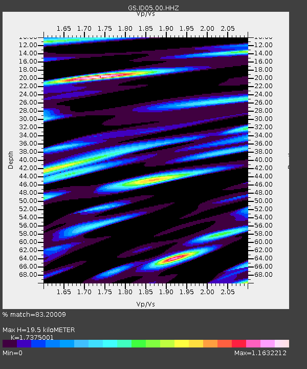
| Estimated Moho Depth: |
19.5 km |
| Estimated Crust Vp/Vs: |
1.74 |
| Assumed Crust Vp: |
6.207 km/s |
| Estimated Crust Vs: |
3.572 km/s |
| Estimated Crust Poisson's Ratio: |
0.25 |
|
| Radial Match: |
83.20009 % |
| Radial Bump: |
400 |
| Transverse Match: |
76.357376 % |
| Transverse Bump: |
400 |
| SOD ConfigId: |
2364251 |
| Insert Time: |
2017-10-10 04:21:51.999 +0000 |
| GWidth: |
2.5 |
| Max Bumps: |
400 |
| Tol: |
0.001 |
|
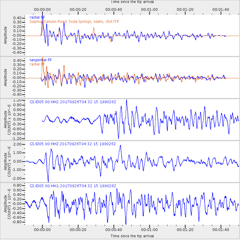
Signal To Noise
| Channel | StoN | STA | LTA |
| GS:ID05:00:HHZ:20170926T04:32:15.199026Z | 13.39444 | 8.8656486E-7 | 6.6189024E-8 |
| GS:ID05:00:HH1:20170926T04:32:15.199026Z | 3.7234612 | 3.2020694E-7 | 8.599712E-8 |
| GS:ID05:00:HH2:20170926T04:32:15.199026Z | 2.8538053 | 3.2003888E-7 | 1.1214461E-7 |
| Arrivals |
| Ps | 2.4 SECOND |
| PpPs | 8.4 SECOND |
| PsPs/PpSs | 11 SECOND |


