
Station GS ID05 - Sulphur Canyon Road, Soda Springs, Idaho, USA
Network: GS - US Geological Survey Networks
Nearby stations (2 deg radius)
| Station | Name | (Lat, Lon) | Start / End | Elevation |
| ID05 | Sulphur Canyon Road, Soda Springs, Idaho, USA | (42.64, -111.46) | 2017-09-07 / 2599-12-31 | 2262 m |
| Crust2 Type: | M8,thick extended crust, 1.5 km seds. |
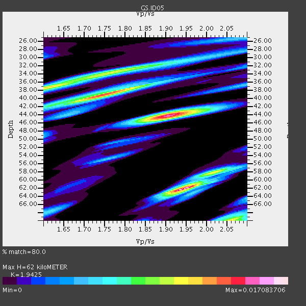
| Thickness Estimate: | 62 km |
| Thickness StdDev: | 12 km |
| Vp/Vs Estimate: | 1.94 |
| Vp/Vs StdDev: | 0.12 |
| Vs Estimate: | 3.195 km/s |
| Poisson's Ratio: | 0.32 |
| Peak Value: | 0.02 |
| Assumed Vp: | 6.207 km/s |
| Ps Weight: | 0.33333334 |
| PpPs Weight: | 0.33333334 |
| PsPs Weight: | 0.33333328 |
| Residual Complexity: | 0.908 |
| Nearby stations H: | +- |
| (2.0 deg) Vp/Vs: | +- |
1 with match > 90% ( 5.5555553 %) and 4 with match > 80% ( 22.222221 %) out of 18.
Download stack as xyz text file.
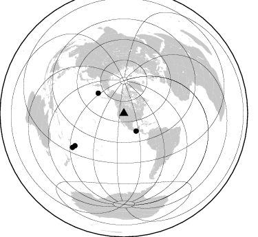
Azimuth Distribution of Events:
Prior Results for this Station
| Study | Thickness | Vp/Vs | Vp | Vs | Poissons Ratio | Extra |
| EARS | 62 km | 1.94 | 6.207 km/s | 3.195 km/s | 0.32 | |
| Crust2.0 | 37 km | 1.78 | 6.207 km/s | 3.489 km/s | 0.27 | M8,thick extended crust, 1.5 km seds. |
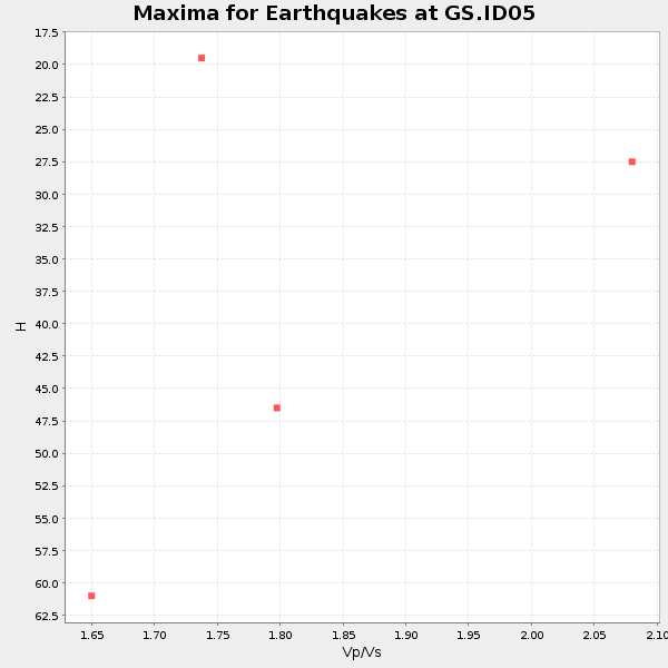
| Global Maxima | 62 km | 1.94 | 6.207 km/s | 3.195 km/s | 0.32 | amp=0.017083706 |
| Local Maxima 1 | 44 km | 1.91 | 6.207 km/s | 3.25 km/s | 0.31 | amp=0.014937078 |
| Local Maxima 2 | 39 km | 1.75 | 6.207 km/s | 3.557 km/s | 0.26 | amp=0.013954765 |
| Local Maxima 3 | 70 km | 2.06 | 6.207 km/s | 3.017 km/s | 0.35 | amp=0.011851069 |
| Local Maxima 4 | 37 km | 1.62 | 6.207 km/s | 3.837 km/s | 0.19 | amp=0.011355376 |
| Predicted Arrivals for vertical incidence (zero ray parameter) | |
| Ps | 9.41 SECOND |
| PpPs | 29.39 SECOND |
| PsPs/PpSs | 38.81 SECOND |
Events Processed for this Station
Download zip of receiver functions as SAC
Plot maxima for each earthquake.
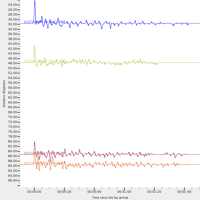
Events Used in the Stack
(4 events)| Radial Match | Distance | Baz | FERegion | Time | Lat/Lon | Depth | Magnitude |
| 94.21025 | 31.4 deg | 145.627 deg | Near Coast Of Chiapas, Mexico | 2017/09/08 04:49:21 GMT | (15.1, -93.7) | 70 km | 8.1 Mww |
| 88.9422 | 85.2 deg | 236.454 deg | Tonga Islands | 2017/10/18 12:00:59 GMT | (-20.6, -173.9) | 10 km | 6.0 Mww |
| 83.20009 | 89.4 deg | 236.505 deg | South Of Fiji Islands | 2017/09/26 04:20:00 GMT | (-23.7, -176.9) | 98 km | 6.4 mww |
| 81.27993 | 47.5 deg | 307.998 deg | Rat Islands, Aleutian Islands | 2017/10/08 22:34:33 GMT | (52.4, 176.8) | 112 km | 6.6 mww |
Losers
(14 events)| Radial Match | Distance | Baz | FERegion | Time | Lat/Lon | Depth | Magnitude | Reason |
| 79.04604 | 74.9 deg | 307.106 deg | Off East Coast Of Honshu, Japan | 2017/10/06 07:59:33 GMT | (37.5, 144.0) | 10 km | 6.0 Mww | |
| 76.64215 | 72.0 deg | 138.308 deg | Northern Chile | 2017/10/10 06:32:20 GMT | (-18.5, -69.6) | 82 km | 6.3 Mww | |
| 61.676067 | 29.9 deg | 146.531 deg | Oaxaca, Mexico | 2017/10/14 00:20:57 GMT | (16.2, -94.8) | 49 km | 5.5 Mww | |
| 59.36494 | 85.2 deg | 298.156 deg | Volcano Islands, Japan Region | 2017/09/11 17:35:09 GMT | (24.0, 142.3) | 35 km | 5.7 Mww | |
| 57.44292 | 30.9 deg | 146.898 deg | Near Coast Of Oaxaca, Mexico | 2017/09/18 14:19:12 GMT | (15.3, -94.6) | 10 km | 5.6 Mww | |
| 55.340714 | 31.2 deg | 146.161 deg | Near Coast Of Oaxaca, Mexico | 2017/09/19 07:53:13 GMT | (15.1, -94.1) | 16 km | 5.5 Mww | |
| 50.49033 | 73.8 deg | 310.124 deg | Near East Coast Of Honshu, Japan | 2017/09/26 20:22:11 GMT | (40.3, 142.4) | 36 km | 5.8 Mww | |
| 47.392715 | 84.5 deg | 141.74 deg | Cordoba Province, Argentina | 2017/10/12 18:59:08 GMT | (-31.0, -65.6) | 157 km | 5.5 Mww | |
| 44.859516 | 98.1 deg | 311.943 deg | Taiwan | 2017/09/20 14:29:56 GMT | (23.3, 121.8) | 22 km | 5.3 Mww | |
| 36.967896 | 72.6 deg | 310.995 deg | Hokkaido, Japan Region | 2017/09/10 08:44:24 GMT | (41.8, 142.9) | 45 km | 5.5 Mww | |
| 36.727726 | 31.4 deg | 146.315 deg | Off Coast Of Chiapas, Mexico | 2017/09/29 04:00:22 GMT | (14.9, -94.0) | 22 km | 5.6 mb | |
| 29.437437 | 74.1 deg | 307.093 deg | Off East Coast Of Honshu, Japan | 2017/09/20 16:37:16 GMT | (38.0, 144.7) | 10 km | 6.1 Mww | |
| 28.393318 | 86.4 deg | 92.035 deg | Central Mid-Atlantic Ridge | 2017/10/06 02:03:48 GMT | (1.0, -25.5) | 10 km | 5.5 Mww | |
| 27.244694 | 76.7 deg | 308.361 deg | Near East Coast Of Honshu, Japan | 2017/10/06 14:56:40 GMT | (37.1, 141.2) | 47 km | 5.4 Mww |

