You are here: Home > Network List > GE - GEOFON Stations List
> Station HLG UKiel/GEOFON Station Helgoland, Germany > Earthquake Result Viewer
HLG UKiel/GEOFON Station Helgoland, Germany - Earthquake Result Viewer
| Earthquake location: |
E. Russia-N.E. China Border Reg. |
| Earthquake latitude/longitude: |
43.8/130.7 |
| Earthquake time(UTC): |
2002/06/28 (179) 17:19:30 GMT |
| Earthquake Depth: |
566 km |
| Earthquake Magnitude: |
6.7 MB, 7.3 MW, 7.3 MW |
| Earthquake Catalog/Contributor: |
WHDF/NEIC |
|
| Network: |
GE GEOFON |
| Station: |
HLG UKiel/GEOFON Station Helgoland, Germany |
| Lat/Lon: |
54.18 N/7.88 E |
| Elevation: |
41 m |
|
| Distance: |
70.9 deg |
| Az: |
328.475 deg |
| Baz: |
40.14 deg |
| Ray Param: |
0.052752513 |
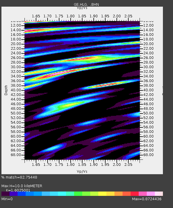
| Estimated Moho Depth: |
10.0 km |
| Estimated Crust Vp/Vs: |
1.60 |
| Assumed Crust Vp: |
5.989 km/s |
| Estimated Crust Vs: |
3.737 km/s |
| Estimated Crust Poisson's Ratio: |
0.18 |
|
| Radial Match: |
82.75448 % |
| Radial Bump: |
400 |
| Transverse Match: |
74.7413 % |
| Transverse Bump: |
400 |
| SOD ConfigId: |
20082 |
| Insert Time: |
2010-03-09 04:35:07.623 +0000 |
| GWidth: |
2.5 |
| Max Bumps: |
400 |
| Tol: |
0.001 |
|

Signal To Noise
| Channel | StoN | STA | LTA |
| GE:HLG: :BHN:20020628T17:29:19.944011Z | 1.0330049 | 1.3855364E-6 | 1.341268E-6 |
| GE:HLG: :BHE:20020628T17:29:19.944011Z | 1.0378172 | 1.6280567E-6 | 1.5687316E-6 |
| GE:HLG: :BHZ:20020628T17:29:19.944011Z | 3.9537463 | 5.85229E-6 | 1.4801886E-6 |
| Arrivals |
| Ps | 1.0 SECOND |
| PpPs | 4.2 SECOND |
| PsPs/PpSs | 5.2 SECOND |


