
Station GE HLG - UKiel/GEOFON Station Helgoland, Germany
Network: GE - GEOFON
Nearby stations (2 deg radius)
| Station | Name | (Lat, Lon) | Start / End | Elevation |
| HLG | UKiel/GEOFON Station Helgoland, Germany | (54.18, 7.88) | 2001-12-14 / 2002-06-20 | 41 m |
| HLG | UKiel/GEOFON Station Helgoland, Germany | (54.18, 7.88) | 2002-06-20 / 2499-01-01 | 41 m |
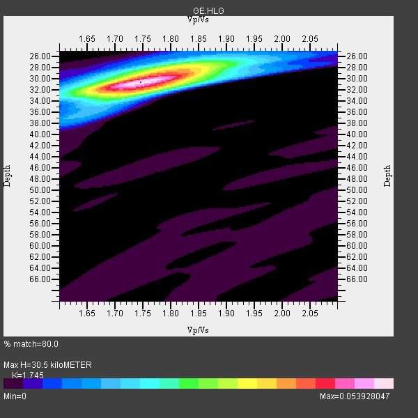
| Crust2 Type: | C4,continental shelf, 3.5 km seds. |
| Thickness Estimate: | 30 km |
| Thickness StdDev: | 0.4 km |
| Vp/Vs Estimate: | 1.75 |
| Vp/Vs StdDev: | 0.01 |
| Vs Estimate: | 3.432 km/s |
| Poisson's Ratio: | 0.26 |
| Peak Value: | 0.05 |
| Assumed Vp: | 5.989 km/s |
| Ps Weight: | 0.33333334 |
| PpPs Weight: | 0.33333334 |
| PsPs Weight: | 0.33333328 |
| Residual Complexity: | 0.480 |
| Nearby stations H: | +- |
| (2.0 deg) Vp/Vs: | +- |
16 with match > 90% ( 41.025642 %) and 38 with match > 80% ( 97.4359 %) out of 39.
Download stack as xyz text file.
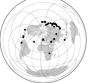
Azimuth Distribution of Events:
Prior Results for this Station
| Study | Thickness | Vp/Vs | Vp | Vs | Poissons Ratio | Extra |
| EARS | 30 km | 1.75 | 5.989 km/s | 3.432 km/s | 0.26 | |
| Crust2.0 | 32 km | 1.81 | 5.989 km/s | 3.317 km/s | 0.28 | C4,continental shelf, 3.5 km seds. |
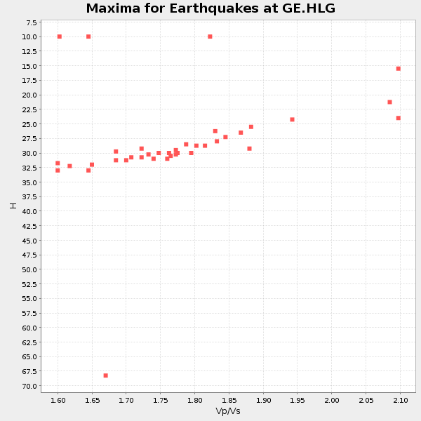
| Global Maxima | 30 km | 1.75 | 5.989 km/s | 3.432 km/s | 0.26 | amp=0.053928047 |
| Local Maxima 1 | 28 km | 1.82 | 5.989 km/s | 3.291 km/s | 0.28 | amp=0.028361142 |
| Local Maxima 2 | 32 km | 1.76 | 5.989 km/s | 3.403 km/s | 0.26 | amp=0.020221911 |
| Local Maxima 3 | 28 km | 1.76 | 5.989 km/s | 3.398 km/s | 0.26 | amp=0.008150115 |
| Local Maxima 4 | 38 km | 1.64 | 5.989 km/s | 3.652 km/s | 0.20 | amp=0.0041847783 |
| Predicted Arrivals for vertical incidence (zero ray parameter) | |
| Ps | 3.79 SECOND |
| PpPs | 13.98 SECOND |
| PsPs/PpSs | 17.77 SECOND |
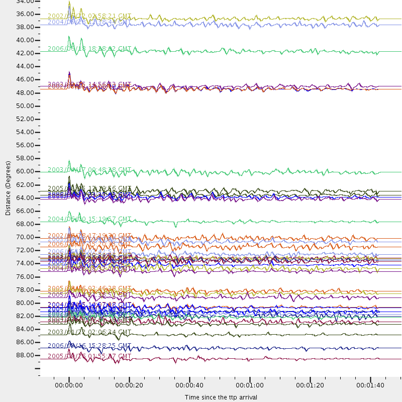
Events Processed for this Station
Download zip of receiver functions as SAC
Plot maxima for each earthquake.
Events Used in the Stack
(38 events)| Radial Match | Distance | Baz | FERegion | Time | Lat/Lon | Depth | Magnitude |
| 97.89915 | 75.4 deg | 23.883 deg | Kuril Islands | 2006/11/15 11:14:13 GMT | (46.6, 153.3) | 10 km | 6.5 MB, 7.8 MS, 8.3 MW, 7.9 MW |
| 97.41294 | 87.1 deg | 298.398 deg | Near Coast Of Jalisco, Mexico | 2003/01/22 02:06:34 GMT | (18.8, -104.1) | 24 km | 6.5 MB, 7.6 MS, 7.6 MW, 7.4 MW |
| 97.23701 | 83.7 deg | 56.809 deg | Taiwan Region | 2002/03/31 06:52:50 GMT | (24.3, 122.2) | 33 km | 6.4 MB, 7.4 MS, 7.1 MW, 7.1 MW |
| 96.42074 | 68.1 deg | 16.583 deg | Kamchatka Peninsula, Russia | 2004/06/10 15:19:57 GMT | (55.7, 160.0) | 189 km | 6.1 MB, 6.9 MW, 6.9 MW |
| 96.24412 | 91.2 deg | 262.067 deg | Northern Peru | 2005/09/26 01:55:37 GMT | (-5.7, -76.4) | 115 km | 6.7 MB, 7.5 MW, 7.5 MW |
| 94.88286 | 64.0 deg | 11.113 deg | Eastern Siberia, Russia | 2006/04/20 23:25:02 GMT | (60.9, 167.1) | 22 km | 6.8 MB, 7.6 MS, 7.6 MW, 7.3 MW |
| 94.68292 | 76.5 deg | 30.812 deg | Hokkaido, Japan Region | 2004/11/28 18:32:14 GMT | (43.0, 145.1) | 39 km | 6.4 MB, 6.7 MS, 7.0 MW, 7.0 MW |
| 94.18605 | 82.6 deg | 40.956 deg | Near S. Coast Of Honshu, Japan | 2004/09/05 14:57:18 GMT | (33.2, 137.1) | 10 km | 6.2 MB, 7.1 MS, 7.4 MW, 7.4 MW |
| 92.73379 | 79.8 deg | 35.01 deg | Near East Coast Of Honshu, Japan | 2005/08/16 02:46:28 GMT | (38.3, 142.0) | 36 km | 6.5 MB, 6.8 MS, 7.2 MW, 7.1 MW |
| 92.17608 | 74.6 deg | 6.436 deg | Rat Islands, Aleutian Islands | 2003/03/17 16:36:17 GMT | (51.3, 178.0) | 33 km | 5.9 MB, 6.7 MS, 7.0 MW, 7.0 MW |
| 91.936195 | 45.8 deg | 86.261 deg | Hindu Kush Region, Afghanistan | 2002/03/03 12:08:07 GMT | (36.4, 70.4) | 209 km | 6.3 MB |
| 91.57529 | 71.5 deg | 17.418 deg | Off East Coast Of Kamchatka | 2003/03/15 19:41:28 GMT | (52.2, 160.4) | 30 km | 5.6 MB, 5.8 MS, 6.0 MW, 6.0 MW |
| 91.054436 | 82.5 deg | 41.35 deg | Near S. Coast Of Western Honshu | 2004/09/05 10:07:07 GMT | (33.1, 136.6) | 14 km | 6.7 MB, 7.0 MS, 7.2 MW, 7.0 MW |
| 90.4071 | 45.8 deg | 86.153 deg | Hindu Kush Region, Afghanistan | 2002/03/03 12:08:19 GMT | (36.5, 70.5) | 226 km | 6.6 MB, 7.4 MW, 7.3 MW |
| 90.04779 | 80.2 deg | 45.398 deg | Kyushu, Japan | 2006/06/11 20:01:26 GMT | (33.1, 131.1) | 140 km | 5.9 MB, 6.3 MW, 6.3 MW |
| 90.02009 | 62.9 deg | 155.341 deg | Lake Tanganyika Region | 2005/12/05 12:19:56 GMT | (-6.2, 29.8) | 22 km | 6.4 MB, 7.2 MS, 6.8 MW, 6.7 MW |
| 89.172775 | 33.9 deg | 106.157 deg | Western Iran | 2002/06/22 02:58:21 GMT | (35.6, 49.0) | 10 km | 6.2 MB, 6.4 MS, 6.5 MW, 6.5 MW |
| 88.03055 | 83.2 deg | 37.218 deg | Off East Coast Of Honshu, Japan | 2004/05/29 20:56:09 GMT | (34.3, 141.4) | 16 km | 5.6 MB, 6.6 MS, 6.5 MW, 6.3 MW |
| 87.4893 | 59.9 deg | 66.795 deg | Qinghai, China | 2003/04/17 00:48:38 GMT | (37.5, 96.5) | 14 km | 6.2 MB, 6.3 MS, 6.4 MW, 6.2 MW |
| 87.23965 | 89.4 deg | 90.62 deg | Northern Sumatra, Indonesia | 2006/05/16 15:28:25 GMT | (0.1, 97.1) | 12 km | 6.6 MB, 6.8 MS, 6.8 MW, 6.8 MW |
| 86.60426 | 85.0 deg | 50.451 deg | Ryukyu Islands, Japan | 2004/07/22 09:45:14 GMT | (26.5, 128.9) | 21 km | 6.1 MB, 5.7 MS, 6.1 MW, 6.1 MW |
| 86.39734 | 74.2 deg | 7.086 deg | Rat Islands, Aleutian Islands | 2003/06/15 19:24:33 GMT | (51.6, 176.9) | 20 km | 6.0 MB, 6.4 MS, 6.5 MW, 6.5 MW |
| 86.37506 | 74.8 deg | 4.683 deg | Andreanof Islands, Aleutian Is. | 2006/07/08 20:40:00 GMT | (51.2, -179.3) | 22 km | 6.2 MB, 6.4 MS, 6.6 MW, 6.6 MW |
| 86.14894 | 84.2 deg | 56.554 deg | Taiwan Region | 2001/12/18 04:02:58 GMT | (24.0, 122.7) | 14 km | 6.3 MB, 7.3 MS, 6.9 MW, 6.8 MW |
| 85.53113 | 76.0 deg | 29.738 deg | Kuril Islands | 2005/09/21 02:25:08 GMT | (43.9, 146.1) | 103 km | 6.0 MB, 6.1 MW, 6.0 MW |
| 85.06489 | 63.7 deg | 10.78 deg | Eastern Siberia, Russia | 2006/04/21 11:14:15 GMT | (61.4, 167.5) | 12 km | 5.8 MB, 5.8 MS, 6.1 MW, 6.1 MW |
| 84.77059 | 85.4 deg | 55.821 deg | Southwestern Ryukyu Isl., Japan | 2002/03/26 03:45:48 GMT | (23.3, 124.1) | 33 km | 5.8 MB, 6.6 MS, 6.4 MW, 6.4 MW |
| 84.02005 | 35.0 deg | 102.753 deg | Northern And Central Iran | 2004/05/28 12:38:44 GMT | (36.2, 51.6) | 17 km | 6.2 MB, 6.4 MS, 6.3 MW, 6.2 MW |
| 83.687546 | 73.6 deg | 358.179 deg | Fox Islands, Aleutian Islands | 2006/05/10 02:42:51 GMT | (52.5, -169.3) | 18 km | 6.1 MB, 6.2 MS, 6.4 MW, 6.3 MW |
| 83.32782 | 80.9 deg | 33.006 deg | Off East Coast Of Honshu, Japan | 2005/11/14 21:38:51 GMT | (38.1, 144.9) | 11 km | 6.7 MB, 6.8 MS, 7.0 MW, 6.9 MW |
| 83.322975 | 72.3 deg | 31.395 deg | Sakhalin, Russia | 2006/08/17 15:20:35 GMT | (46.5, 141.9) | 17 km | 6.0 MB, 5.2 MS, 5.6 MW, 5.5 MW |
| 83.06802 | 45.4 deg | 87.506 deg | Hindu Kush Region, Afghanistan | 2002/03/25 14:56:33 GMT | (36.1, 69.3) | 8.0 km | 5.9 MB, 6.2 MS, 6.1 MW, 6.0 MW |
| 82.75448 | 70.9 deg | 40.14 deg | E. Russia-N.E. China Border Reg. | 2002/06/28 17:19:30 GMT | (43.8, 130.7) | 566 km | 6.7 MB, 7.3 MW, 7.3 MW |
| 82.315544 | 64.3 deg | 11.9 deg | Eastern Siberia, Russia | 2006/04/21 04:32:43 GMT | (60.5, 165.8) | 9.0 km | 6.3 MB, 5.6 MS, 6.1 MW, 6.1 ME |
| 82.08355 | 39.5 deg | 257.318 deg | Northern Mid-Atlantic Ridge | 2006/06/18 18:28:02 GMT | (33.0, -39.7) | 10 km | 5.5 MB, 5.8 MS, 5.9 MW, 5.9 MW |
| 81.62329 | 83.3 deg | 279.856 deg | Near Coast Of Nicaragua | 2005/07/02 02:16:43 GMT | (11.2, -86.2) | 27 km | 5.6 MB, 6.4 MS, 6.6 MW, 6.6 MW |
| 81.58179 | 84.0 deg | 276.66 deg | Costa Rica | 2002/06/16 02:46:14 GMT | (8.8, -84.0) | 35 km | 5.4 MB, 6.2 MS, 6.4 MW, 6.4 MW |
| 81.05407 | 74.3 deg | 356.257 deg | South Of Aleutian Islands | 2004/08/07 09:30:16 GMT | (51.8, -166.3) | 8.0 km | 6.3 MB, 5.4 MS, 6.0 MW, 6.0 MW |
Losers
(1 events)| Radial Match | Distance | Baz | FERegion | Time | Lat/Lon | Depth | Magnitude | Reason |
| 72.952515 | 88.1 deg | 89.586 deg | Northern Sumatra, Indonesia | 2005/07/05 01:52:02 GMT | (1.8, 97.1) | 21 km | 6.2 MB, 6.8 MS, 6.7 MW, 6.6 MW |
