You are here: Home > Network List > GE - GEOFON Stations List
> Station HLG UKiel/GEOFON Station Helgoland, Germany > Earthquake Result Viewer
HLG UKiel/GEOFON Station Helgoland, Germany - Earthquake Result Viewer
| Earthquake location: |
Costa Rica |
| Earthquake latitude/longitude: |
8.8/-84.0 |
| Earthquake time(UTC): |
2002/06/16 (167) 02:46:14 GMT |
| Earthquake Depth: |
35 km |
| Earthquake Magnitude: |
5.4 MB, 6.2 MS, 6.4 MW, 6.4 MW |
| Earthquake Catalog/Contributor: |
WHDF/NEIC |
|
| Network: |
GE GEOFON |
| Station: |
HLG UKiel/GEOFON Station Helgoland, Germany |
| Lat/Lon: |
54.18 N/7.88 E |
| Elevation: |
41 m |
|
| Distance: |
84.0 deg |
| Az: |
36.202 deg |
| Baz: |
276.66 deg |
| Ray Param: |
0.045709968 |
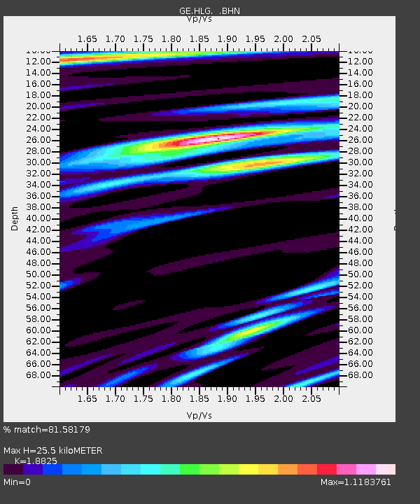
| Estimated Moho Depth: |
25.5 km |
| Estimated Crust Vp/Vs: |
1.88 |
| Assumed Crust Vp: |
5.989 km/s |
| Estimated Crust Vs: |
3.181 km/s |
| Estimated Crust Poisson's Ratio: |
0.30 |
|
| Radial Match: |
81.58179 % |
| Radial Bump: |
400 |
| Transverse Match: |
65.254524 % |
| Transverse Bump: |
400 |
| SOD ConfigId: |
20082 |
| Insert Time: |
2010-03-09 04:35:09.388 +0000 |
| GWidth: |
2.5 |
| Max Bumps: |
400 |
| Tol: |
0.001 |
|

Signal To Noise
| Channel | StoN | STA | LTA |
| GE:HLG: :BHN:20020616T02:58:09.894014Z | 0.81204784 | 4.9370504E-7 | 6.079753E-7 |
| GE:HLG: :BHE:20020616T02:58:09.894014Z | 1.07971 | 6.327663E-7 | 5.8605207E-7 |
| GE:HLG: :BHZ:20020616T02:58:09.894014Z | 2.4167168 | 1.3174222E-6 | 5.451289E-7 |
| Arrivals |
| Ps | 3.8 SECOND |
| PpPs | 12 SECOND |
| PsPs/PpSs | 16 SECOND |


