You are here: Home > Network List > GE - GEOFON Stations List
> Station HLG UKiel/GEOFON Station Helgoland, Germany > Earthquake Result Viewer
HLG UKiel/GEOFON Station Helgoland, Germany - Earthquake Result Viewer
| Earthquake location: |
Hindu Kush Region, Afghanistan |
| Earthquake latitude/longitude: |
36.4/70.4 |
| Earthquake time(UTC): |
2002/03/03 (062) 12:08:07 GMT |
| Earthquake Depth: |
209 km |
| Earthquake Magnitude: |
6.3 MB |
| Earthquake Catalog/Contributor: |
WHDF/NEIC |
|
| Network: |
GE GEOFON |
| Station: |
HLG UKiel/GEOFON Station Helgoland, Germany |
| Lat/Lon: |
54.18 N/7.88 E |
| Elevation: |
41 m |
|
| Distance: |
45.8 deg |
| Az: |
313.345 deg |
| Baz: |
86.261 deg |
| Ray Param: |
0.07023039 |
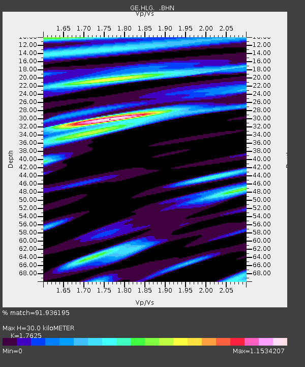
| Estimated Moho Depth: |
30.0 km |
| Estimated Crust Vp/Vs: |
1.76 |
| Assumed Crust Vp: |
5.989 km/s |
| Estimated Crust Vs: |
3.398 km/s |
| Estimated Crust Poisson's Ratio: |
0.26 |
|
| Radial Match: |
91.936195 % |
| Radial Bump: |
400 |
| Transverse Match: |
75.98705 % |
| Transverse Bump: |
400 |
| SOD ConfigId: |
20082 |
| Insert Time: |
2010-03-09 04:35:15.570 +0000 |
| GWidth: |
2.5 |
| Max Bumps: |
400 |
| Tol: |
0.001 |
|

Signal To Noise
| Channel | StoN | STA | LTA |
| GE:HLG: :BHN:20020303T12:15:38.225009Z | 1.168783 | 1.1561508E-6 | 9.89192E-7 |
| GE:HLG: :BHE:20020303T12:15:38.225009Z | 1.8566606 | 1.701832E-6 | 9.166091E-7 |
| GE:HLG: :BHZ:20020303T12:15:38.225009Z | 3.544432 | 4.0783993E-6 | 1.1506496E-6 |
| Arrivals |
| Ps | 4.0 SECOND |
| PpPs | 13 SECOND |
| PsPs/PpSs | 17 SECOND |


