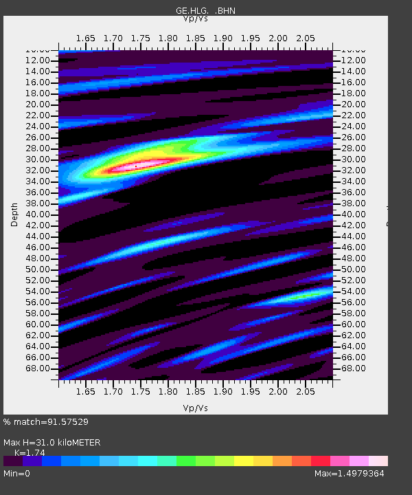
HLG UKiel/GEOFON Station Helgoland, Germany - Earthquake Result Viewer

Earthquake location: Off East Coast Of Kamchatka
Earthquake latitude/longitude: 52.2/160.4
Earthquake time(UTC): 2003/03/15 (074) 19:41:28 GMT
Earthquake Depth: 30 km
Earthquake Magnitude: 5.6 MB, 5.8 MS, 6.0 MW, 6.0 MW
Earthquake Catalog/Contributor: WHDF/NEIC
Network: GE GEOFON
Station: HLG UKiel/GEOFON Station Helgoland, Germany
Lat/Lon: 54.18 N/7.88 E
Elevation: 41 m
Distance: 71.5 deg
Az: 343.371 deg
Baz: 17.418 deg
Ray Param: 0.05425297
Estimated Moho Depth: 31.0 km
Estimated Crust Vp/Vs: 1.74
Assumed Crust Vp: 5.989 km/s
Estimated Crust Vs: 3.442 km/s
Estimated Crust Poisson's Ratio: 0.25
Radial Match: 91.57529 %
Radial Bump: 400
Transverse Match: 70.35352 %
Transverse Bump: 400
SOD ConfigId: 4714
Insert Time: 2010-03-09 04:35:21.802 +0000
GWidth: 2.5
Max Bumps: 400
Tol: 0.001

Signal To Noise

ChannelStoNSTALTA
GE:HLG: :BHN:20030315T19:52:15.444019Z1.3788183.425731E-72.4845417E-7
GE:HLG: :BHE:20030315T19:52:15.444019Z1.18874552.583506E-72.1733045E-7
GE:HLG: :BHZ:20030315T19:52:15.444019Z3.08030568.6628086E-72.812321E-7
Arrivals
Ps4.0 SECOND
PpPs14 SECOND
PsPs/PpSs18 SECOND