You are here: Home > Network List > GE - GEOFON Stations List
> Station HLG UKiel/GEOFON Station Helgoland, Germany > Earthquake Result Viewer
HLG UKiel/GEOFON Station Helgoland, Germany - Earthquake Result Viewer
| Earthquake location: |
Kamchatka Peninsula, Russia |
| Earthquake latitude/longitude: |
55.7/160.0 |
| Earthquake time(UTC): |
2004/06/10 (162) 15:19:57 GMT |
| Earthquake Depth: |
189 km |
| Earthquake Magnitude: |
6.1 MB, 6.9 MW, 6.9 MW |
| Earthquake Catalog/Contributor: |
WHDF/NEIC |
|
| Network: |
GE GEOFON |
| Station: |
HLG UKiel/GEOFON Station Helgoland, Germany |
| Lat/Lon: |
54.18 N/7.88 E |
| Elevation: |
41 m |
|
| Distance: |
68.1 deg |
| Az: |
342.772 deg |
| Baz: |
16.583 deg |
| Ray Param: |
0.055973094 |
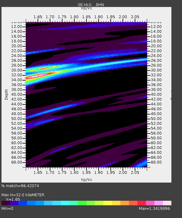
| Estimated Moho Depth: |
32.0 km |
| Estimated Crust Vp/Vs: |
1.65 |
| Assumed Crust Vp: |
5.989 km/s |
| Estimated Crust Vs: |
3.63 km/s |
| Estimated Crust Poisson's Ratio: |
0.21 |
|
| Radial Match: |
96.42074 % |
| Radial Bump: |
400 |
| Transverse Match: |
87.9343 % |
| Transverse Bump: |
400 |
| SOD ConfigId: |
2459 |
| Insert Time: |
2010-03-09 04:35:31.632 +0000 |
| GWidth: |
2.5 |
| Max Bumps: |
400 |
| Tol: |
0.001 |
|

Signal To Noise
| Channel | StoN | STA | LTA |
| GE:HLG: :BHN:20040610T15:30:06.434021Z | 18.1822 | 4.1721587E-6 | 2.2946391E-7 |
| GE:HLG: :BHE:20040610T15:30:06.434021Z | 5.644822 | 1.1614876E-6 | 2.057616E-7 |
| GE:HLG: :BHZ:20040610T15:30:06.434021Z | 51.59601 | 1.1448164E-5 | 2.218808E-7 |
| Arrivals |
| Ps | 3.6 SECOND |
| PpPs | 14 SECOND |
| PsPs/PpSs | 17 SECOND |


