You are here: Home > Network List > GE - GEOFON Stations List
> Station HLG UKiel/GEOFON Station Helgoland, Germany > Earthquake Result Viewer
HLG UKiel/GEOFON Station Helgoland, Germany - Earthquake Result Viewer
| Earthquake location: |
Lake Tanganyika Region |
| Earthquake latitude/longitude: |
-6.2/29.8 |
| Earthquake time(UTC): |
2005/12/05 (339) 12:19:56 GMT |
| Earthquake Depth: |
22 km |
| Earthquake Magnitude: |
6.4 MB, 7.2 MS, 6.8 MW, 6.7 MW |
| Earthquake Catalog/Contributor: |
WHDF/NEIC |
|
| Network: |
GE GEOFON |
| Station: |
HLG UKiel/GEOFON Station Helgoland, Germany |
| Lat/Lon: |
54.18 N/7.88 E |
| Elevation: |
41 m |
|
| Distance: |
62.9 deg |
| Az: |
345.72 deg |
| Baz: |
155.341 deg |
| Ray Param: |
0.059870385 |
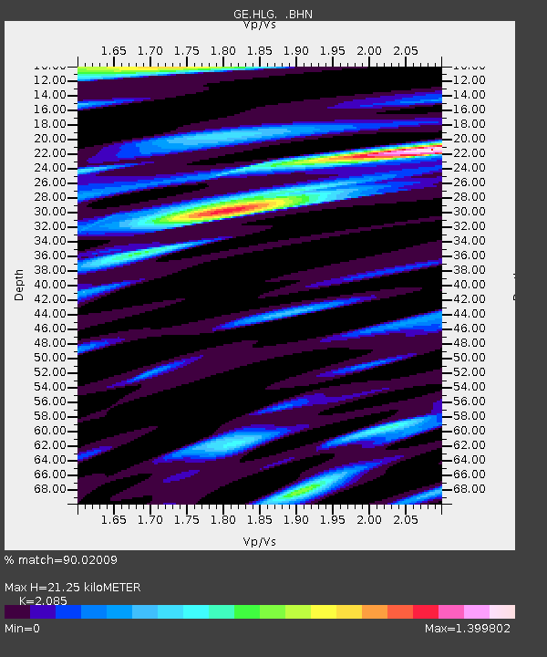
| Estimated Moho Depth: |
21.25 km |
| Estimated Crust Vp/Vs: |
2.09 |
| Assumed Crust Vp: |
5.989 km/s |
| Estimated Crust Vs: |
2.872 km/s |
| Estimated Crust Poisson's Ratio: |
0.35 |
|
| Radial Match: |
90.02009 % |
| Radial Bump: |
400 |
| Transverse Match: |
69.34171 % |
| Transverse Bump: |
400 |
| SOD ConfigId: |
2422 |
| Insert Time: |
2010-03-09 04:35:36.130 +0000 |
| GWidth: |
2.5 |
| Max Bumps: |
400 |
| Tol: |
0.001 |
|

Signal To Noise
| Channel | StoN | STA | LTA |
| GE:HLG: :BHN:20051205T12:29:50.294011Z | 2.9640408 | 1.4983397E-6 | 5.0550574E-7 |
| GE:HLG: :BHE:20051205T12:29:50.294011Z | 2.486054 | 1.0818709E-6 | 4.3517596E-7 |
| GE:HLG: :BHZ:20051205T12:29:50.294011Z | 6.908631 | 3.64688E-6 | 5.2787306E-7 |
| Arrivals |
| Ps | 4.0 SECOND |
| PpPs | 11 SECOND |
| PsPs/PpSs | 15 SECOND |


