You are here: Home > Network List > GS - US Geological Survey Networks Stations List
> Station ID05 Sulphur Canyon Road, Soda Springs, Idaho, USA > Earthquake Result Viewer
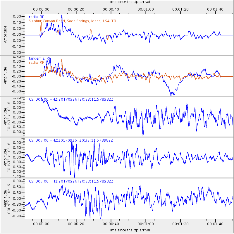
ID05 Sulphur Canyon Road, Soda Springs, Idaho, USA - Earthquake Result Viewer
*The percent match for this event was below the threshold and hence no stack was calculated.
| Earthquake location: |
Near East Coast Of Honshu, Japan |
| Earthquake latitude/longitude: |
40.3/142.4 |
| Earthquake time(UTC): |
2017/09/26 (269) 20:22:11 GMT |
| Earthquake Depth: |
36 km |
| Earthquake Magnitude: |
5.8 Mww |
| Earthquake Catalog/Contributor: |
NEIC PDE/us |
|
| Network: |
GS US Geological Survey Networks |
| Station: |
ID05 Sulphur Canyon Road, Soda Springs, Idaho, USA |
| Lat/Lon: |
42.64 N/111.46 W |
| Elevation: |
2262 m |
|
| Distance: |
73.8 deg |
| Az: |
47.556 deg |
| Baz: |
310.124 deg |
| Ray Param: |
$rayparam |
*The percent match for this event was below the threshold and hence was not used in the summary stack. |
|
| Radial Match: |
50.49033 % |
| Radial Bump: |
400 |
| Transverse Match: |
34.371937 % |
| Transverse Bump: |
400 |
| SOD ConfigId: |
2364251 |
| Insert Time: |
2017-10-10 20:27:47.827 +0000 |
| GWidth: |
2.5 |
| Max Bumps: |
400 |
| Tol: |
0.001 |
|
Signal To Noise
| Channel | StoN | STA | LTA |
| GS:ID05:00:HHZ:20170926T20:33:11.578982Z | 1.930516 | 2.5244222E-7 | 1.3076412E-7 |
| GS:ID05:00:HH1:20170926T20:33:11.578982Z | 0.67019147 | 4.260955E-7 | 6.3578176E-7 |
| GS:ID05:00:HH2:20170926T20:33:11.578982Z | 0.5968423 | 2.653633E-7 | 4.4461208E-7 |
| Arrivals |
| Ps | |
| PpPs | |
| PsPs/PpSs | |


