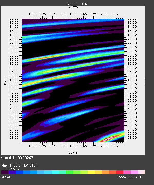
ISP GEOFON/MedNet Station Isparta, Turkey - Earthquake Result Viewer

Earthquake location: Afghanistan-Tajikistan Bord Reg.
Earthquake latitude/longitude: 36.5/71.1
Earthquake time(UTC): 1998/02/20 (051) 12:18:06 GMT
Earthquake Depth: 236 km
Earthquake Magnitude: 5.8 MB, 5.7 MS, 6.4 UNKNOWN, 6.3 MW
Earthquake Catalog/Contributor: WHDF/NEIC
Network: GE GEOFON
Station: ISP GEOFON/MedNet Station Isparta, Turkey
Lat/Lon: 37.84 N/30.51 E
Elevation: 1100 m
Distance: 32.2 deg
Az: 284.841 deg
Baz: 79.767 deg
Ray Param: 0.077997446
Estimated Moho Depth: 68.5 km
Estimated Crust Vp/Vs: 2.02
Assumed Crust Vp: 6.232 km/s
Estimated Crust Vs: 3.093 km/s
Estimated Crust Poisson's Ratio: 0.34
Radial Match: 88.18097 %
Radial Bump: 400
Transverse Match: 70.93114 %
Transverse Bump: 400
SOD ConfigId: 6273
Insert Time: 2010-03-09 04:50:50.332 +0000
GWidth: 2.5
Max Bumps: 400
Tol: 0.001

Signal To Noise

ChannelStoNSTALTA
GE:ISP: :BHN:19980220T12:23:41.628009Z2.12239311.5224003E-77.173037E-8
GE:ISP: :BHE:19980220T12:23:41.628009Z12.5539361.286204E-61.0245424E-7
GE:ISP: :BHZ:19980220T12:23:41.628009Z33.3512652.8258803E-68.473083E-8
Arrivals
Ps12 SECOND
PpPs31 SECOND
PsPs/PpSs43 SECOND