You are here: Home > Network List > GE - GEOFON Stations List
> Station ISP GEOFON/MedNet Station Isparta, Turkey > Earthquake Result Viewer
ISP GEOFON/MedNet Station Isparta, Turkey - Earthquake Result Viewer
| Earthquake location: |
Kyrgyzstan |
| Earthquake latitude/longitude: |
41.0/74.3 |
| Earthquake time(UTC): |
1997/01/09 (009) 13:43:31 GMT |
| Earthquake Depth: |
22 km |
| Earthquake Magnitude: |
5.7 MB, 5.8 MS, 5.7 UNKNOWN, 5.7 MW |
| Earthquake Catalog/Contributor: |
WHDF/NEIC |
|
| Network: |
GE GEOFON |
| Station: |
ISP GEOFON/MedNet Station Isparta, Turkey |
| Lat/Lon: |
37.84 N/30.51 E |
| Elevation: |
1100 m |
|
| Distance: |
33.7 deg |
| Az: |
279.172 deg |
| Baz: |
70.64 deg |
| Ray Param: |
0.078062326 |
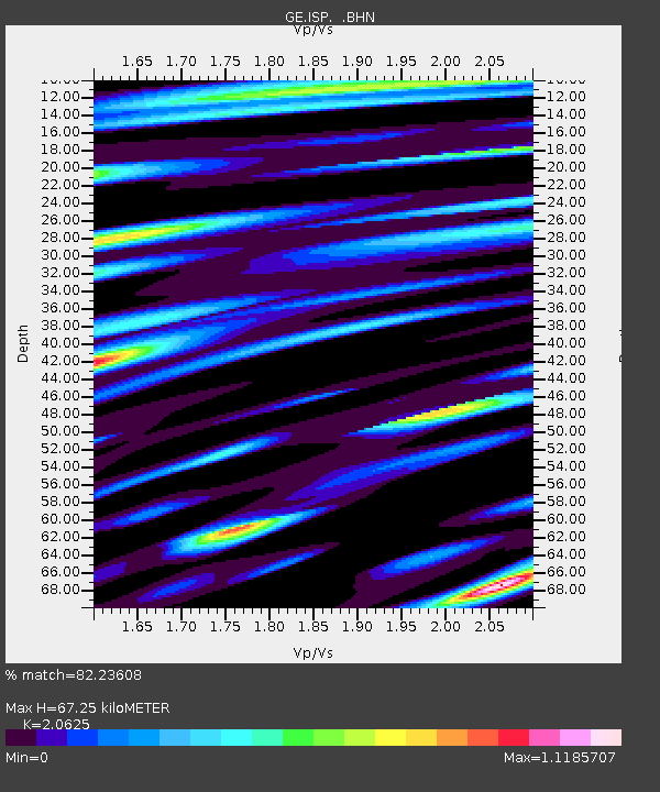
| Estimated Moho Depth: |
67.25 km |
| Estimated Crust Vp/Vs: |
2.06 |
| Assumed Crust Vp: |
6.232 km/s |
| Estimated Crust Vs: |
3.021 km/s |
| Estimated Crust Poisson's Ratio: |
0.35 |
|
| Radial Match: |
82.23608 % |
| Radial Bump: |
400 |
| Transverse Match: |
81.63606 % |
| Transverse Bump: |
400 |
| SOD ConfigId: |
4480 |
| Insert Time: |
2010-03-09 04:51:03.305 +0000 |
| GWidth: |
2.5 |
| Max Bumps: |
400 |
| Tol: |
0.001 |
|

Signal To Noise
| Channel | StoN | STA | LTA |
| GE:ISP: :BHN:19970109T13:49:40.333008Z | 7.552151 | 1.206548E-6 | 1.5976215E-7 |
| GE:ISP: :BHE:19970109T13:49:40.333008Z | 1.2888126 | 1.8583131E-7 | 1.44188E-7 |
| GE:ISP: :BHZ:19970109T13:49:40.333008Z | 3.6658278 | 6.0543164E-7 | 1.6515551E-7 |
| Arrivals |
| Ps | 12 SECOND |
| PpPs | 31 SECOND |
| PsPs/PpSs | 43 SECOND |


