You are here: Home > Network List > GE - GEOFON Stations List
> Station ISP GEOFON/MedNet Station Isparta, Turkey > Earthquake Result Viewer
ISP GEOFON/MedNet Station Isparta, Turkey - Earthquake Result Viewer
| Earthquake location: |
Sulawesi, Indonesia |
| Earthquake latitude/longitude: |
-1.1/123.6 |
| Earthquake time(UTC): |
2000/05/04 (125) 04:21:16 GMT |
| Earthquake Depth: |
26 km |
| Earthquake Magnitude: |
6.7 MB, 7.5 MS, 7.6 MW, 7.5 ME |
| Earthquake Catalog/Contributor: |
WHDF/NEIC |
|
| Network: |
GE GEOFON |
| Station: |
ISP GEOFON/MedNet Station Isparta, Turkey |
| Lat/Lon: |
37.84 N/30.51 E |
| Elevation: |
1100 m |
|
| Distance: |
93.1 deg |
| Az: |
307.655 deg |
| Baz: |
88.997 deg |
| Ray Param: |
0.041320965 |
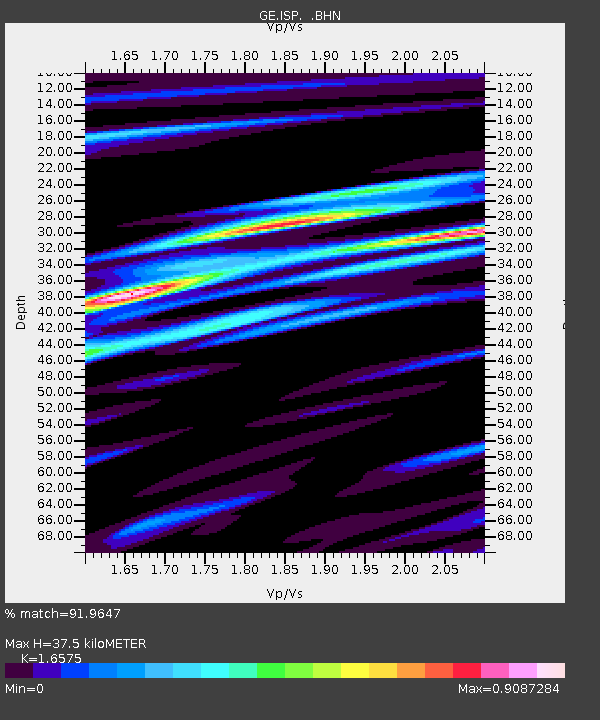
| Estimated Moho Depth: |
37.5 km |
| Estimated Crust Vp/Vs: |
1.66 |
| Assumed Crust Vp: |
6.232 km/s |
| Estimated Crust Vs: |
3.76 km/s |
| Estimated Crust Poisson's Ratio: |
0.21 |
|
| Radial Match: |
91.9647 % |
| Radial Bump: |
400 |
| Transverse Match: |
82.3094 % |
| Transverse Bump: |
400 |
| SOD ConfigId: |
3744 |
| Insert Time: |
2010-03-09 04:52:08.995 +0000 |
| GWidth: |
2.5 |
| Max Bumps: |
400 |
| Tol: |
0.001 |
|

Signal To Noise
| Channel | StoN | STA | LTA |
| GE:ISP: :BHN:20000504T04:33:56.173013Z | 1.2333493 | 1.1777943E-7 | 9.5495594E-8 |
| GE:ISP: :BHE:20000504T04:33:56.173013Z | 9.175014 | 1.1890297E-6 | 1.2959433E-7 |
| GE:ISP: :BHZ:20000504T04:33:56.173013Z | 34.52579 | 4.65493E-6 | 1.3482472E-7 |
| Arrivals |
| Ps | 4.0 SECOND |
| PpPs | 16 SECOND |
| PsPs/PpSs | 20 SECOND |


