You are here: Home > Network List > GE - GEOFON Stations List
> Station ISP GEOFON/MedNet Station Isparta, Turkey > Earthquake Result Viewer
ISP GEOFON/MedNet Station Isparta, Turkey - Earthquake Result Viewer
| Earthquake location: |
Southern Sumatra, Indonesia |
| Earthquake latitude/longitude: |
-4.0/101.7 |
| Earthquake time(UTC): |
2001/01/16 (016) 13:25:01 GMT |
| Earthquake Depth: |
33 km |
| Earthquake Magnitude: |
6.0 MB |
| Earthquake Catalog/Contributor: |
WHDF/NEIC |
|
| Network: |
GE GEOFON |
| Station: |
ISP GEOFON/MedNet Station Isparta, Turkey |
| Lat/Lon: |
37.84 N/30.51 E |
| Elevation: |
1100 m |
|
| Distance: |
77.8 deg |
| Az: |
309.908 deg |
| Baz: |
104.842 deg |
| Ray Param: |
0.0500637 |
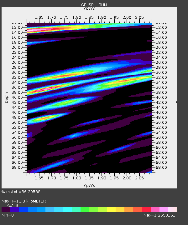
| Estimated Moho Depth: |
13.0 km |
| Estimated Crust Vp/Vs: |
1.60 |
| Assumed Crust Vp: |
6.232 km/s |
| Estimated Crust Vs: |
3.895 km/s |
| Estimated Crust Poisson's Ratio: |
0.18 |
|
| Radial Match: |
86.39588 % |
| Radial Bump: |
400 |
| Transverse Match: |
79.36858 % |
| Transverse Bump: |
400 |
| SOD ConfigId: |
3744 |
| Insert Time: |
2010-03-09 04:52:59.777 +0000 |
| GWidth: |
2.5 |
| Max Bumps: |
400 |
| Tol: |
0.001 |
|

Signal To Noise
| Channel | StoN | STA | LTA |
| GE:ISP: :BHN:20010116T13:36:23.718Z | 0.94748795 | 5.998209E-8 | 6.3306445E-8 |
| GE:ISP: :BHE:20010116T13:36:23.718Z | 0.89186394 | 1.6165072E-7 | 1.8125041E-7 |
| GE:ISP: :BHZ:20010116T13:36:23.718Z | 3.3583896 | 4.7240408E-7 | 1.4066386E-7 |
| Arrivals |
| Ps | 1.3 SECOND |
| PpPs | 5.3 SECOND |
| PsPs/PpSs | 6.5 SECOND |


