You are here: Home > Network List > GE - GEOFON Stations List
> Station ISP GEOFON/MedNet Station Isparta, Turkey > Earthquake Result Viewer
ISP GEOFON/MedNet Station Isparta, Turkey - Earthquake Result Viewer
| Earthquake location: |
South Of Alaska |
| Earthquake latitude/longitude: |
53.8/-161.1 |
| Earthquake time(UTC): |
2002/05/25 (145) 05:36:31 GMT |
| Earthquake Depth: |
33 km |
| Earthquake Magnitude: |
5.5 MB, 6.1 MS, 6.5 MW, 6.4 MW |
| Earthquake Catalog/Contributor: |
WHDF/NEIC |
|
| Network: |
GE GEOFON |
| Station: |
ISP GEOFON/MedNet Station Isparta, Turkey |
| Lat/Lon: |
37.84 N/30.51 E |
| Elevation: |
1100 m |
|
| Distance: |
88.2 deg |
| Az: |
350.815 deg |
| Baz: |
6.866 deg |
| Ray Param: |
0.042751007 |
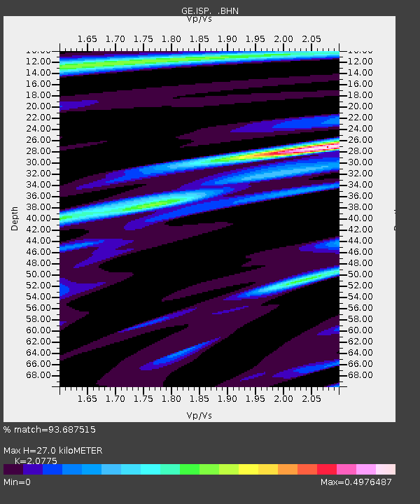
| Estimated Moho Depth: |
27.0 km |
| Estimated Crust Vp/Vs: |
2.08 |
| Assumed Crust Vp: |
6.232 km/s |
| Estimated Crust Vs: |
3.0 km/s |
| Estimated Crust Poisson's Ratio: |
0.35 |
|
| Radial Match: |
93.687515 % |
| Radial Bump: |
400 |
| Transverse Match: |
83.79602 % |
| Transverse Bump: |
400 |
| SOD ConfigId: |
20082 |
| Insert Time: |
2010-03-09 04:53:28.259 +0000 |
| GWidth: |
2.5 |
| Max Bumps: |
400 |
| Tol: |
0.001 |
|

Signal To Noise
| Channel | StoN | STA | LTA |
| GE:ISP: :BHN:20020525T05:48:48.238005Z | 1.7084535 | 4.1517747E-8 | 2.4301361E-8 |
| GE:ISP: :BHE:20020525T05:48:48.238005Z | 0.8407705 | 4.0974925E-8 | 4.873497E-8 |
| GE:ISP: :BHZ:20020525T05:48:48.238005Z | 5.235676 | 2.619349E-7 | 5.002886E-8 |
| Arrivals |
| Ps | 4.8 SECOND |
| PpPs | 13 SECOND |
| PsPs/PpSs | 18 SECOND |


