You are here: Home > Network List > GE - GEOFON Stations List
> Station ISP GEOFON/MedNet Station Isparta, Turkey > Earthquake Result Viewer
ISP GEOFON/MedNet Station Isparta, Turkey - Earthquake Result Viewer
| Earthquake location: |
Hindu Kush Region, Afghanistan |
| Earthquake latitude/longitude: |
36.4/70.4 |
| Earthquake time(UTC): |
2002/03/03 (062) 12:08:07 GMT |
| Earthquake Depth: |
209 km |
| Earthquake Magnitude: |
6.3 MB |
| Earthquake Catalog/Contributor: |
WHDF/NEIC |
|
| Network: |
GE GEOFON |
| Station: |
ISP GEOFON/MedNet Station Isparta, Turkey |
| Lat/Lon: |
37.84 N/30.51 E |
| Elevation: |
1100 m |
|
| Distance: |
31.7 deg |
| Az: |
284.749 deg |
| Baz: |
80.111 deg |
| Ray Param: |
0.07832521 |
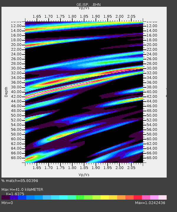
| Estimated Moho Depth: |
41.0 km |
| Estimated Crust Vp/Vs: |
1.64 |
| Assumed Crust Vp: |
6.232 km/s |
| Estimated Crust Vs: |
3.806 km/s |
| Estimated Crust Poisson's Ratio: |
0.20 |
|
| Radial Match: |
85.80396 % |
| Radial Bump: |
400 |
| Transverse Match: |
71.594635 % |
| Transverse Bump: |
400 |
| SOD ConfigId: |
20082 |
| Insert Time: |
2010-03-09 04:53:36.864 +0000 |
| GWidth: |
2.5 |
| Max Bumps: |
400 |
| Tol: |
0.001 |
|

Signal To Noise
| Channel | StoN | STA | LTA |
| GE:ISP: :BHN:20020303T12:13:41.338015Z | 2.3384807 | 6.898744E-8 | 2.9500967E-8 |
| GE:ISP: :BHE:20020303T12:13:41.338015Z | 5.894409 | 9.5277534E-7 | 1.6164051E-7 |
| GE:ISP: :BHZ:20020303T12:13:41.338015Z | 9.200655 | 2.0427333E-6 | 2.2202043E-7 |
| Arrivals |
| Ps | 4.5 SECOND |
| PpPs | 16 SECOND |
| PsPs/PpSs | 21 SECOND |


