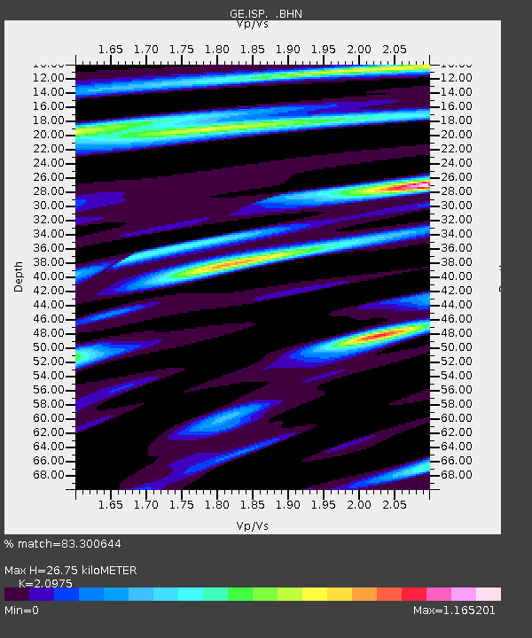
ISP GEOFON/MedNet Station Isparta, Turkey - Earthquake Result Viewer

Earthquake location: Near West Coast Of Honshu, Japan
Earthquake latitude/longitude: 37.2/138.8
Earthquake time(UTC): 2004/10/23 (297) 08:56:00 GMT
Earthquake Depth: 16 km
Earthquake Magnitude: 6.4 MB, 6.3 MS, 6.6 MW, 6.4 MW
Earthquake Catalog/Contributor: WHDF/NEIC
Network: GE GEOFON
Station: ISP GEOFON/MedNet Station Isparta, Turkey
Lat/Lon: 37.84 N/30.51 E
Elevation: 1100 m
Distance: 80.2 deg
Az: 310.282 deg
Baz: 50.278 deg
Ray Param: 0.048416518
Estimated Moho Depth: 26.75 km
Estimated Crust Vp/Vs: 2.10
Assumed Crust Vp: 6.232 km/s
Estimated Crust Vs: 2.971 km/s
Estimated Crust Poisson's Ratio: 0.35
Radial Match: 83.300644 %
Radial Bump: 400
Transverse Match: 77.36465 %
Transverse Bump: 400
SOD ConfigId: 2459
Insert Time: 2010-03-09 04:54:17.621 +0000
GWidth: 2.5
Max Bumps: 400
Tol: 0.001

Signal To Noise

ChannelStoNSTALTA
GE:ISP: :BHN:20041023T09:07:39.110Z2.0090042.088247E-71.0394439E-7
GE:ISP: :BHE:20041023T09:07:39.110Z4.7569893.656341E-77.68625E-8
GE:ISP: :BHZ:20041023T09:07:39.110Z9.6453511.0495874E-61.0881795E-7
Arrivals
Ps4.8 SECOND
PpPs13 SECOND
PsPs/PpSs18 SECOND