You are here: Home > Network List > IC - New China Digital Seismograph Network Stations List
> Station HIA Hailar, Neimenggu Autonomous Region, China > Earthquake Result Viewer
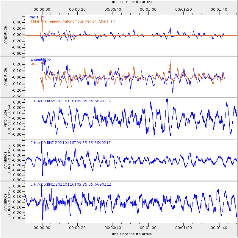
HIA Hailar, Neimenggu Autonomous Region, China - Earthquake Result Viewer
*The percent match for this event was below the threshold and hence no stack was calculated.
| Earthquake location: |
Southwest Of Sumatra, Indonesia |
| Earthquake latitude/longitude: |
-6.4/103.9 |
| Earthquake time(UTC): |
2021/01/16 (016) 09:26:39 GMT |
| Earthquake Depth: |
10 km |
| Earthquake Magnitude: |
5.2 Mww |
| Earthquake Catalog/Contributor: |
NEIC PDE/us |
|
| Network: |
IC New China Digital Seismograph Network |
| Station: |
HIA Hailar, Neimenggu Autonomous Region, China |
| Lat/Lon: |
49.27 N/119.74 E |
| Elevation: |
620 m |
|
| Distance: |
57.2 deg |
| Az: |
12.291 deg |
| Baz: |
198.844 deg |
| Ray Param: |
$rayparam |
*The percent match for this event was below the threshold and hence was not used in the summary stack. |
|
| Radial Match: |
61.3021 % |
| Radial Bump: |
400 |
| Transverse Match: |
59.680847 % |
| Transverse Bump: |
400 |
| SOD ConfigId: |
23341671 |
| Insert Time: |
2021-01-30 10:29:42.140 +0000 |
| GWidth: |
2.5 |
| Max Bumps: |
400 |
| Tol: |
0.001 |
|
Signal To Noise
| Channel | StoN | STA | LTA |
| IC:HIA:00:BHZ:20210116T09:35:55.669021Z | 2.7326314 | 2.4703994E-7 | 9.0403674E-8 |
| IC:HIA:00:BH1:20210116T09:35:55.669021Z | 1.8857844 | 1.3838016E-7 | 7.33807E-8 |
| IC:HIA:00:BH2:20210116T09:35:55.669021Z | 0.774937 | 8.915243E-8 | 1.1504475E-7 |
| Arrivals |
| Ps | |
| PpPs | |
| PsPs/PpSs | |


