You are here: Home > Network List > SP - South Carolina Earth Physics Project Stations List
> Station TRLBY Terrell's Bay High School, Marion County, SC USA > Earthquake Result Viewer
TRLBY Terrell's Bay High School, Marion County, SC USA - Earthquake Result Viewer
| Earthquake location: |
Near Coast Of Northern Chile |
| Earthquake latitude/longitude: |
-27.5/-70.6 |
| Earthquake time(UTC): |
2002/04/18 (108) 16:08:36 GMT |
| Earthquake Depth: |
62 km |
| Earthquake Magnitude: |
6.2 MB, 6.7 MW, 6.6 MW |
| Earthquake Catalog/Contributor: |
WHDF/NEIC |
|
| Network: |
SP South Carolina Earth Physics Project |
| Station: |
TRLBY Terrell's Bay High School, Marion County, SC USA |
| Lat/Lon: |
34.03 N/79.36 W |
| Elevation: |
15 m |
|
| Distance: |
61.8 deg |
| Az: |
351.735 deg |
| Baz: |
171.158 deg |
| Ray Param: |
0.06050323 |
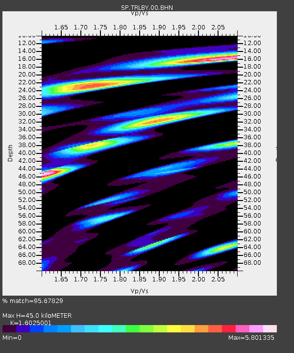
| Estimated Moho Depth: |
45.0 km |
| Estimated Crust Vp/Vs: |
1.60 |
| Assumed Crust Vp: |
6.565 km/s |
| Estimated Crust Vs: |
4.096 km/s |
| Estimated Crust Poisson's Ratio: |
0.18 |
|
| Radial Match: |
95.67829 % |
| Radial Bump: |
400 |
| Transverse Match: |
81.28114 % |
| Transverse Bump: |
400 |
| SOD ConfigId: |
2277 |
| Insert Time: |
2010-02-25 17:51:14.714 +0000 |
| GWidth: |
2.5 |
| Max Bumps: |
400 |
| Tol: |
0.001 |
|
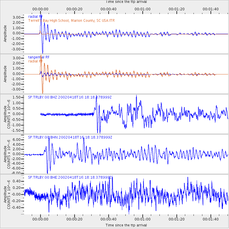
Signal To Noise
| Channel | StoN | STA | LTA |
| SP:TRLBY:00:BHN:20020418T16:18:18.378999Z | 16.652746 | 2.6567275E-6 | 1.595369E-7 |
| SP:TRLBY:00:BHE:20020418T16:18:18.378999Z | 0.76089704 | 9.0459245E-8 | 1.18885E-7 |
| SP:TRLBY:00:BHZ:20020418T16:18:18.378999Z | 14.307387 | 7.076278E-7 | 4.945891E-8 |
| Arrivals |
| Ps | 4.4 SECOND |
| PpPs | 17 SECOND |
| PsPs/PpSs | 21 SECOND |


