
Station SP TRLBY - Terrell's Bay High School, Marion County, SC USA
Network: SP - South Carolina Earth Physics Project
Nearby stations (2 deg radius)
| Station | Name | (Lat, Lon) | Start / End | Elevation |
| TRLBY | Terrell's Bay High School, Marion County, SC USA | (34.03, -79.36) | 2001-09-17 / 2003-05-12 | 15 m |
| Crust2 Type: | DG,thin Platform 1 km seds. |
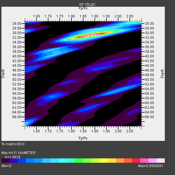
| Thickness Estimate: | 31 km |
| Thickness StdDev: | 3.8 km |
| Vp/Vs Estimate: | 1.88 |
| Vp/Vs StdDev: | 0.01 |
| Vs Estimate: | 3.487 km/s |
| Poisson's Ratio: | 0.30 |
| Peak Value: | 0.56 |
| Assumed Vp: | 6.565 km/s |
| Ps Weight: | 0.33333334 |
| PpPs Weight: | 0.33333334 |
| PsPs Weight: | 0.33333328 |
| Residual Complexity: | 0.435 |
| Nearby stations H: | +- |
| (2.0 deg) Vp/Vs: | +- |
4 with match > 90% ( 44.444443 %) and 6 with match > 80% ( 66.666664 %) out of 9.
Download stack as xyz text file.
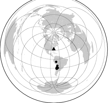
Azimuth Distribution of Events:
Prior Results for this Station
| Study | Thickness | Vp/Vs | Vp | Vs | Poissons Ratio | Extra |
| EARS | 31 km | 1.88 | 6.565 km/s | 3.487 km/s | 0.30 | |
| Crust2.0 | 31 km | 1.78 | 6.565 km/s | 3.684 km/s | 0.27 | DG,thin Platform 1 km seds. |
| Global Maxima | 31 km | 1.88 | 6.565 km/s | 3.487 km/s | 0.30 | amp=0.5569091 |
| Local Maxima 1 | 25 km | 2.10 | 6.565 km/s | 3.13 km/s | 0.35 | amp=0.1937418 |
| Local Maxima 2 | 69 km | 1.60 | 6.565 km/s | 4.103 km/s | 0.18 | amp=0.17064776 |
| Local Maxima 3 | 39 km | 1.73 | 6.565 km/s | 3.8 km/s | 0.25 | amp=0.17049982 |
| Local Maxima 4 | 54 km | 2.00 | 6.565 km/s | 3.282 km/s | 0.33 | amp=0.1317346 |
| Predicted Arrivals for vertical incidence (zero ray parameter) | |
| Ps | 4.17 SECOND |
| PpPs | 13.61 SECOND |
| PsPs/PpSs | 17.78 SECOND |
Events Processed for this Station
Download zip of receiver functions as SAC
Plot maxima for each earthquake.
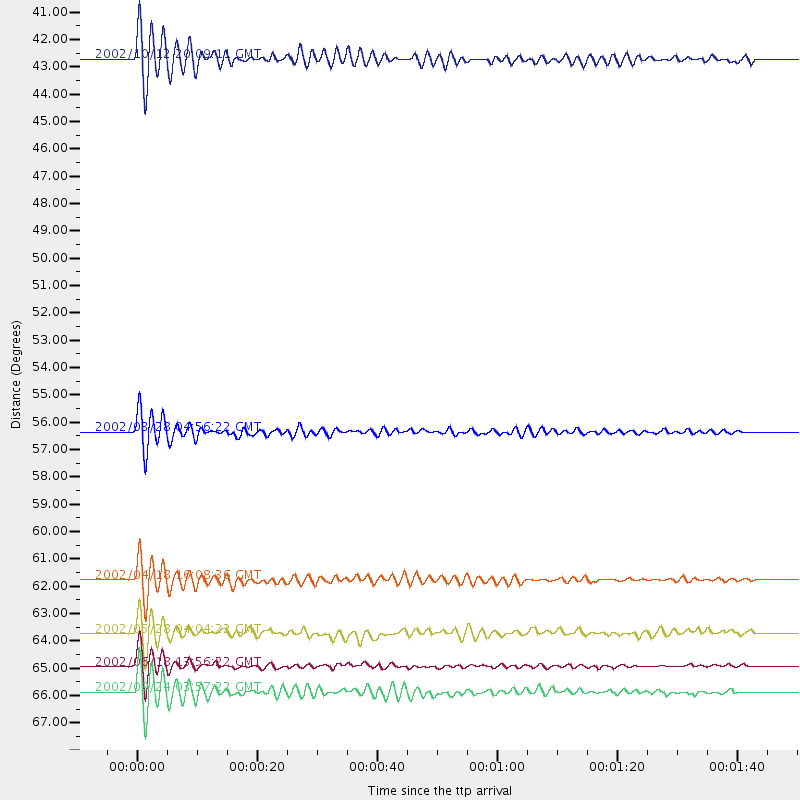
Events Used in the Stack
(6 events)| Radial Match | Distance | Baz | FERegion | Time | Lat/Lon | Depth | Magnitude |
| 97.67057 | 42.7 deg | 168.841 deg | Western Brazil | 2002/10/12 20:09:11 GMT | (-8.3, -71.7) | 534 km | 6.5 MB, 6.9 MW, 6.9 MW |
| 95.98038 | 65.9 deg | 170.501 deg | San Juan Province, Argentina | 2002/09/24 03:57:22 GMT | (-31.5, -69.2) | 120 km | 6.2 MB, 6.4 MW, 6.3 MW |
| 95.67829 | 61.8 deg | 171.158 deg | Near Coast Of Northern Chile | 2002/04/18 16:08:36 GMT | (-27.5, -70.6) | 62 km | 6.2 MB, 6.7 MW, 6.6 MW |
| 94.54566 | 56.4 deg | 167.657 deg | Chile-Bolivia Border Region | 2002/03/28 04:56:22 GMT | (-21.7, -68.3) | 125 km | 6.1 MB, 6.5 MW, 6.5 MW |
| 89.02403 | 65.0 deg | 172.181 deg | Near Coast Of Central Chile | 2002/06/18 13:56:22 GMT | (-30.8, -71.1) | 54 km | 6.0 MB, 6.6 MW, 6.4 MW |
| 83.61346 | 63.7 deg | 167.726 deg | Catamarca Province, Argentina | 2002/05/28 04:04:22 GMT | (-28.9, -66.8) | 22 km | 6.0 MB, 5.7 MS, 6.0 MW, 5.9 MW |
Losers
(3 events)| Radial Match | Distance | Baz | FERegion | Time | Lat/Lon | Depth | Magnitude | Reason |
| 93.25408 | 50.7 deg | 327.338 deg | Central Alaska | 2002/10/23 11:27:19 GMT | (63.5, -147.9) | 4.2 km | 6.0 MB, 6.7 MS, 6.7 MW, 6.7 MW | |
| 90.309586 | 50.4 deg | 327.351 deg | Central Alaska | 2002/11/03 22:12:41 GMT | (63.5, -147.4) | 4.9 km | 7.0 MB, 8.5 MS, 7.9 MW | |
| 83.81817 | 88.9 deg | 331.229 deg | Northwest Of Kuril Islands | 2002/11/17 04:53:53 GMT | (47.8, 146.2) | 459 km | 7.3 MW, 7.3 MW |
