You are here: Home > Network List > SP - South Carolina Earth Physics Project Stations List
> Station TRLBY Terrell's Bay High School, Marion County, SC USA > Earthquake Result Viewer
TRLBY Terrell's Bay High School, Marion County, SC USA - Earthquake Result Viewer
| Earthquake location: |
Near Coast Of Central Chile |
| Earthquake latitude/longitude: |
-30.8/-71.1 |
| Earthquake time(UTC): |
2002/06/18 (169) 13:56:22 GMT |
| Earthquake Depth: |
54 km |
| Earthquake Magnitude: |
6.0 MB, 6.6 MW, 6.4 MW |
| Earthquake Catalog/Contributor: |
WHDF/NEIC |
|
| Network: |
SP South Carolina Earth Physics Project |
| Station: |
TRLBY Terrell's Bay High School, Marion County, SC USA |
| Lat/Lon: |
34.03 N/79.36 W |
| Elevation: |
15 m |
|
| Distance: |
65.0 deg |
| Az: |
352.455 deg |
| Baz: |
172.181 deg |
| Ray Param: |
0.058471657 |
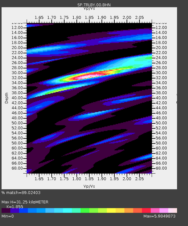
| Estimated Moho Depth: |
31.25 km |
| Estimated Crust Vp/Vs: |
1.86 |
| Assumed Crust Vp: |
6.565 km/s |
| Estimated Crust Vs: |
3.539 km/s |
| Estimated Crust Poisson's Ratio: |
0.30 |
|
| Radial Match: |
89.02403 % |
| Radial Bump: |
400 |
| Transverse Match: |
69.2049 % |
| Transverse Bump: |
400 |
| SOD ConfigId: |
2277 |
| Insert Time: |
2010-02-25 17:51:17.867 +0000 |
| GWidth: |
2.5 |
| Max Bumps: |
400 |
| Tol: |
0.001 |
|
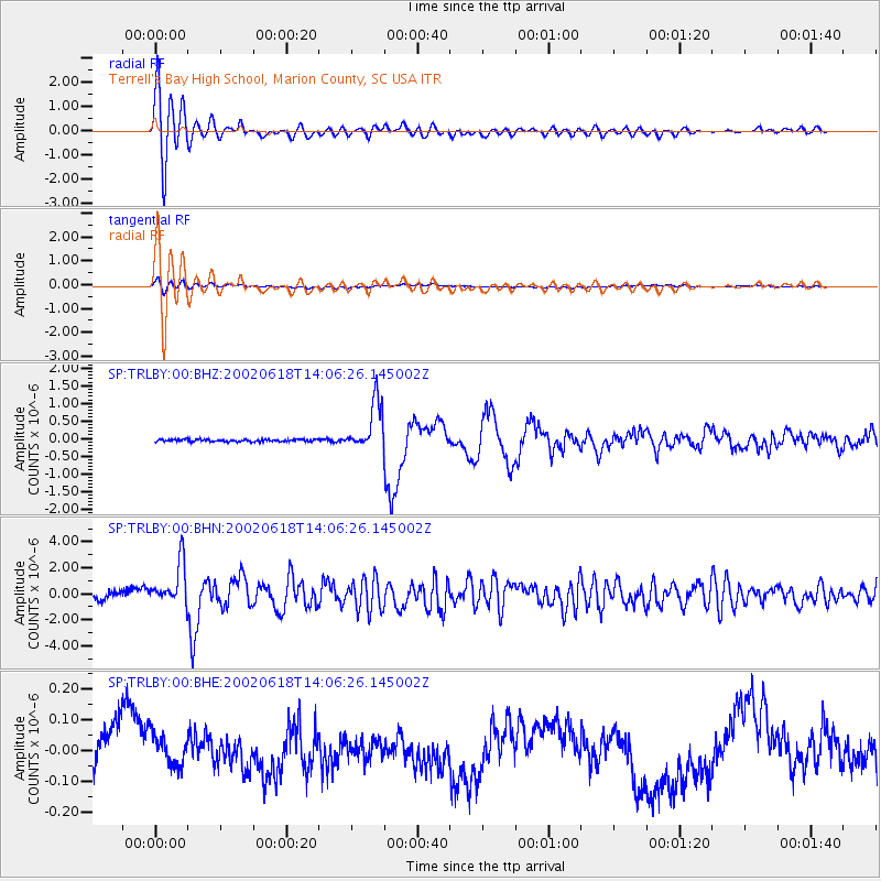
Signal To Noise
| Channel | StoN | STA | LTA |
| SP:TRLBY:00:BHN:20020618T14:06:26.145002Z | 4.5636044 | 1.6579692E-6 | 3.6330258E-7 |
| SP:TRLBY:00:BHE:20020618T14:06:26.145002Z | 0.67325515 | 6.867264E-8 | 1.0200091E-7 |
| SP:TRLBY:00:BHZ:20020618T14:06:26.145002Z | 21.640184 | 6.934736E-7 | 3.2045644E-8 |
| Arrivals |
| Ps | 4.2 SECOND |
| PpPs | 13 SECOND |
| PsPs/PpSs | 17 SECOND |


