You are here: Home > Network List > GE - GEOFON Stations List
> Station GHAR GEOFON/ETHZ Station Gharyan, Libya > Earthquake Result Viewer
GHAR GEOFON/ETHZ Station Gharyan, Libya - Earthquake Result Viewer
| Earthquake location: |
Arabian Sea |
| Earthquake latitude/longitude: |
14.7/55.8 |
| Earthquake time(UTC): |
2002/08/13 (225) 08:37:22 GMT |
| Earthquake Depth: |
10 km |
| Earthquake Magnitude: |
5.8 MB, 5.5 MS, 5.8 MW, 5.6 MW |
| Earthquake Catalog/Contributor: |
WHDF/NEIC |
|
| Network: |
GE GEOFON |
| Station: |
GHAR GEOFON/ETHZ Station Gharyan, Libya |
| Lat/Lon: |
32.12 N/13.09 E |
| Elevation: |
650 m |
|
| Distance: |
42.6 deg |
| Az: |
301.595 deg |
| Baz: |
103.789 deg |
| Ray Param: |
0.073104985 |
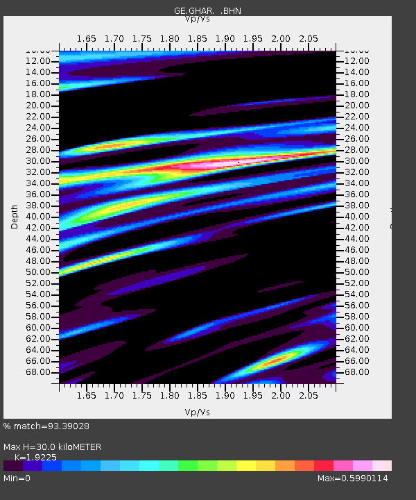
| Estimated Moho Depth: |
30.0 km |
| Estimated Crust Vp/Vs: |
1.92 |
| Assumed Crust Vp: |
6.159 km/s |
| Estimated Crust Vs: |
3.204 km/s |
| Estimated Crust Poisson's Ratio: |
0.31 |
|
| Radial Match: |
93.39028 % |
| Radial Bump: |
357 |
| Transverse Match: |
78.1987 % |
| Transverse Bump: |
400 |
| SOD ConfigId: |
20082 |
| Insert Time: |
2010-03-09 05:05:58.253 +0000 |
| GWidth: |
2.5 |
| Max Bumps: |
400 |
| Tol: |
0.001 |
|

Signal To Noise
| Channel | StoN | STA | LTA |
| GE:GHAR: :BHN:20020813T08:44:47.750011Z | 0.7569828 | 9.7871386E-8 | 1.2929142E-7 |
| GE:GHAR: :BHE:20020813T08:44:47.750011Z | 0.66078764 | 8.904386E-8 | 1.3475412E-7 |
| GE:GHAR: :BHZ:20020813T08:44:47.750011Z | 2.7819383 | 2.7300806E-7 | 9.813592E-8 |
| Arrivals |
| Ps | 4.8 SECOND |
| PpPs | 13 SECOND |
| PsPs/PpSs | 18 SECOND |


