
Station GE GHAR - GEOFON/ETHZ Station Gharyan, Libya
Network: GE - GEOFON
Nearby stations (2 deg radius)
| Station | Name | (Lat, Lon) | Start / End | Elevation |
| GHAR | GEOFON/ETHZ Station Gharyan, Libya | (32.12, 13.09) | 2000-11-25 / 2499-01-01 | 0.6 km |
| Crust2 Type: | T5,Margin /shield transition, 5 km seds. |
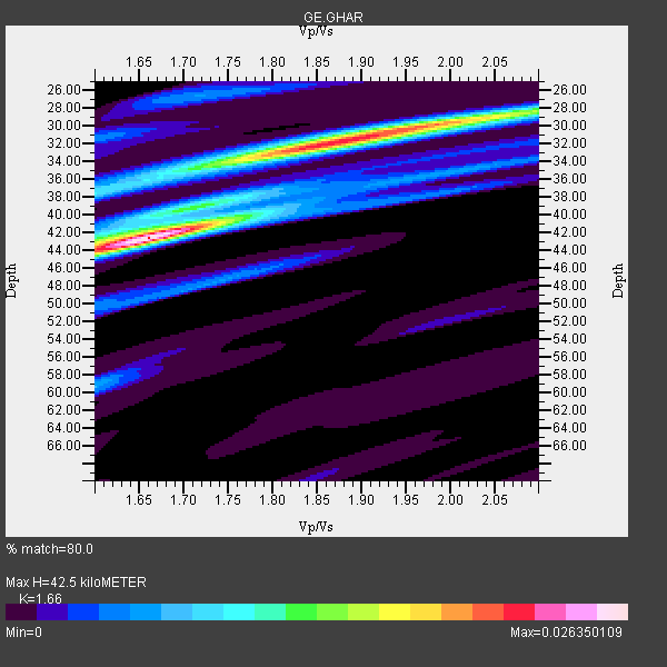
| Thickness Estimate: | 42 km |
| Thickness StdDev: | 5.2 km |
| Vp/Vs Estimate: | 1.66 |
| Vp/Vs StdDev: | 0.11 |
| Vs Estimate: | 3.71 km/s |
| Poisson's Ratio: | 0.22 |
| Peak Value: | 0.03 |
| Assumed Vp: | 6.159 km/s |
| Ps Weight: | 0.33333334 |
| PpPs Weight: | 0.33333334 |
| PsPs Weight: | 0.33333328 |
| Residual Complexity: | 0.753 |
| Nearby stations H: | 38 km +- 5.7 km |
| (2.0 deg) Vp/Vs: | 1.70 +- 0.06 |
8 with match > 90% ( 80.0 %) and 10 with match > 80% ( 100.0 %) out of 10.
Download stack as xyz text file.
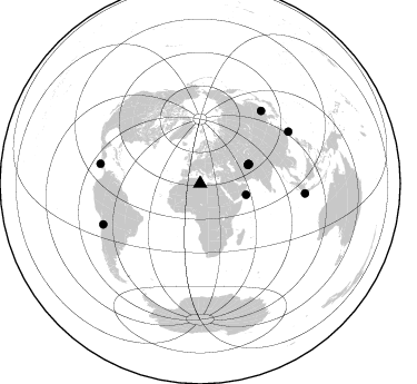
Azimuth Distribution of Events:
Prior Results for this Station
| Study | Thickness | Vp/Vs | Vp | Vs | Poissons Ratio | Extra |
| EARS | 42 km | 1.66 | 6.159 km/s | 3.71 km/s | 0.22 | |
| Crust2.0 | 32 km | 1.79 | 6.159 km/s | 3.434 km/s | 0.27 | T5,Margin /shield transition, 5 km seds. |
| Global Maxima | 42 km | 1.66 | 6.159 km/s | 3.71 km/s | 0.22 | amp=0.026350109 |
| Local Maxima 1 | 32 km | 1.87 | 6.159 km/s | 3.289 km/s | 0.30 | amp=0.021309322 |
| Local Maxima 2 | 29 km | 2.04 | 6.159 km/s | 3.023 km/s | 0.34 | amp=0.012338443 |
| Local Maxima 3 | 38 km | 1.60 | 6.159 km/s | 3.85 km/s | 0.18 | amp=0.008024808 |
| Local Maxima 4 | 59 km | 1.60 | 6.159 km/s | 3.85 km/s | 0.18 | amp=0.0067019784 |
| Predicted Arrivals for vertical incidence (zero ray parameter) | |
| Ps | 4.55 SECOND |
| PpPs | 18.35 SECOND |
| PsPs/PpSs | 22.91 SECOND |
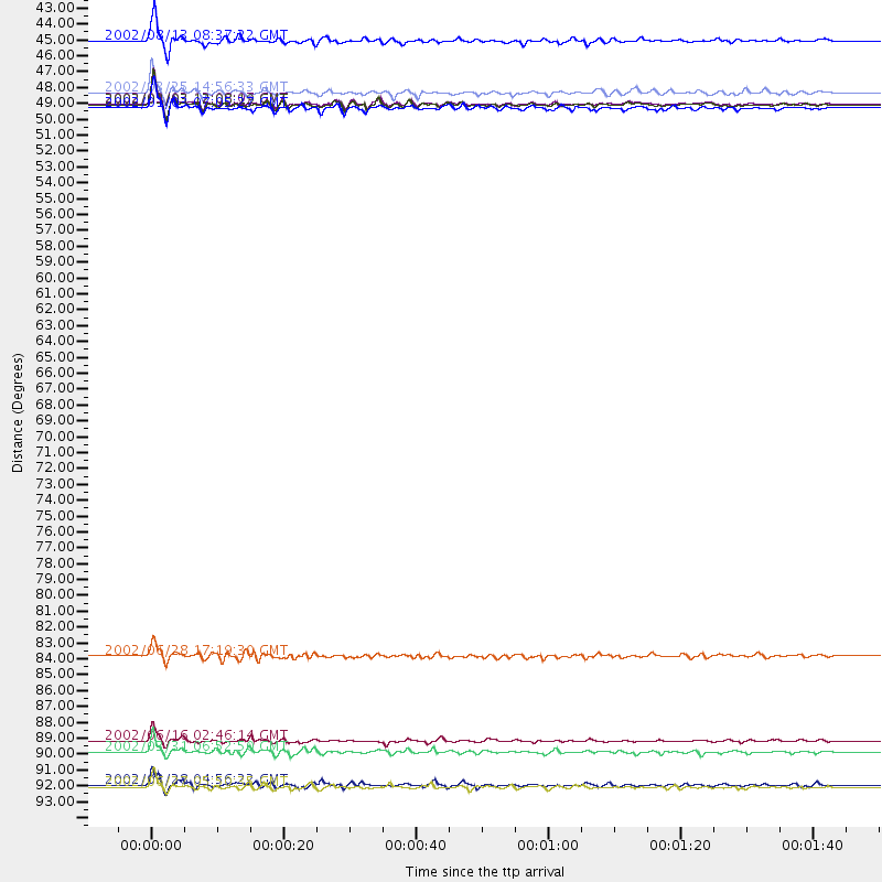
Events Processed for this Station
Download zip of receiver functions as SAC
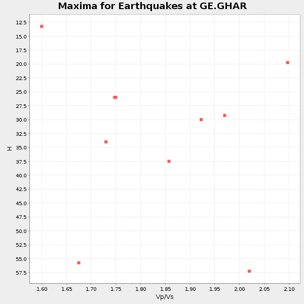
Plot maxima for each earthquake.
Events Used in the Stack
(10 events)| Radial Match | Distance | Baz | FERegion | Time | Lat/Lon | Depth | Magnitude |
| 96.173546 | 92.1 deg | 59.653 deg | Taiwan Region | 2002/03/31 06:52:50 GMT | (24.3, 122.2) | 33 km | 6.4 MB, 7.4 MS, 7.1 MW, 7.1 MW |
| 95.30596 | 94.6 deg | 95.305 deg | Sunda Strait, Indonesia | 2002/06/27 05:50:35 GMT | (-7.0, 104.2) | 11 km | 6.0 MB, 6.9 MS, 6.6 MW, 6.5 MW |
| 94.88856 | 47.0 deg | 68.105 deg | Hindu Kush Region, Afghanistan | 2002/03/03 12:08:19 GMT | (36.5, 70.5) | 226 km | 6.6 MB, 7.4 MW, 7.3 MW |
| 94.75653 | 47.0 deg | 68.212 deg | Hindu Kush Region, Afghanistan | 2002/03/03 12:08:07 GMT | (36.4, 70.4) | 209 km | 6.3 MB |
| 94.481224 | 85.4 deg | 40.12 deg | E. Russia-N.E. China Border Reg. | 2002/06/28 17:19:30 GMT | (43.8, 130.7) | 566 km | 6.7 MB, 7.3 MW, 7.3 MW |
| 93.39028 | 42.6 deg | 103.789 deg | Arabian Sea | 2002/08/13 08:37:22 GMT | (14.7, 55.8) | 10 km | 5.8 MB, 5.5 MS, 5.8 MW, 5.6 MW |
| 92.67454 | 91.3 deg | 281.143 deg | Costa Rica | 2002/06/16 02:46:14 GMT | (8.8, -84.0) | 35 km | 5.4 MB, 6.2 MS, 6.4 MW, 6.4 MW |
| 90.830315 | 47.3 deg | 68.606 deg | Hindu Kush Region, Afghanistan | 2002/01/03 07:05:27 GMT | (36.1, 70.7) | 129 km | 5.8 MB, 6.2 MW, 6.1 MW |
| 88.57615 | 46.2 deg | 68.97 deg | Hindu Kush Region, Afghanistan | 2002/03/25 14:56:33 GMT | (36.1, 69.3) | 8.0 km | 5.9 MB, 6.2 MS, 6.1 MW, 6.0 MW |
| 87.005684 | 94.4 deg | 247.294 deg | Chile-Bolivia Border Region | 2002/03/28 04:56:22 GMT | (-21.7, -68.3) | 125 km | 6.1 MB, 6.5 MW, 6.5 MW |
Losers
(0 events)| Radial Match | Distance | Baz | FERegion | Time | Lat/Lon | Depth | Magnitude | Reason |
