You are here: Home > Network List > GE - GEOFON Stations List
> Station GHAR GEOFON/ETHZ Station Gharyan, Libya > Earthquake Result Viewer
GHAR GEOFON/ETHZ Station Gharyan, Libya - Earthquake Result Viewer
| Earthquake location: |
Taiwan Region |
| Earthquake latitude/longitude: |
24.3/122.2 |
| Earthquake time(UTC): |
2002/03/31 (090) 06:52:50 GMT |
| Earthquake Depth: |
33 km |
| Earthquake Magnitude: |
6.4 MB, 7.4 MS, 7.1 MW, 7.1 MW |
| Earthquake Catalog/Contributor: |
WHDF/NEIC |
|
| Network: |
GE GEOFON |
| Station: |
GHAR GEOFON/ETHZ Station Gharyan, Libya |
| Lat/Lon: |
32.12 N/13.09 E |
| Elevation: |
650 m |
|
| Distance: |
92.1 deg |
| Az: |
306.64 deg |
| Baz: |
59.653 deg |
| Ray Param: |
0.04149897 |
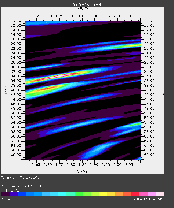
| Estimated Moho Depth: |
34.0 km |
| Estimated Crust Vp/Vs: |
1.73 |
| Assumed Crust Vp: |
6.159 km/s |
| Estimated Crust Vs: |
3.56 km/s |
| Estimated Crust Poisson's Ratio: |
0.25 |
|
| Radial Match: |
96.173546 % |
| Radial Bump: |
397 |
| Transverse Match: |
82.97896 % |
| Transverse Bump: |
400 |
| SOD ConfigId: |
20082 |
| Insert Time: |
2010-03-09 05:06:02.057 +0000 |
| GWidth: |
2.5 |
| Max Bumps: |
400 |
| Tol: |
0.001 |
|

Signal To Noise
| Channel | StoN | STA | LTA |
| GE:GHAR: :BHN:20020331T07:05:25.172007Z | 1.6238972 | 2.4803035E-7 | 1.5273771E-7 |
| GE:GHAR: :BHE:20020331T07:05:25.172007Z | 2.8664122 | 4.0604732E-7 | 1.4165698E-7 |
| GE:GHAR: :BHZ:20020331T07:05:25.172007Z | 7.23244 | 1.0543748E-6 | 1.457841E-7 |
| Arrivals |
| Ps | 4.1 SECOND |
| PpPs | 15 SECOND |
| PsPs/PpSs | 19 SECOND |


