You are here: Home > Network List > CW - Servicio Sismologico Nacional de Cuba (SSNC) Stations List
> Station GNEO Los Guineos, Baracoa, Guantanamo > Earthquake Result Viewer
GNEO Los Guineos, Baracoa, Guantanamo - Earthquake Result Viewer
| Earthquake location: |
Rat Islands, Aleutian Islands |
| Earthquake latitude/longitude: |
52.4/176.8 |
| Earthquake time(UTC): |
2017/10/08 (281) 22:34:33 GMT |
| Earthquake Depth: |
112 km |
| Earthquake Magnitude: |
6.6 mww |
| Earthquake Catalog/Contributor: |
NEIC PDE/us |
|
| Network: |
CW Servicio Sismologico Nacional de Cuba (SSNC) |
| Station: |
GNEO Los Guineos, Baracoa, Guantanamo |
| Lat/Lon: |
20.33 N/74.59 W |
| Elevation: |
558 m |
|
| Distance: |
84.8 deg |
| Az: |
63.263 deg |
| Baz: |
324.379 deg |
| Ray Param: |
0.04494792 |
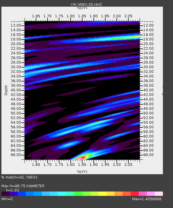
| Estimated Moho Depth: |
69.75 km |
| Estimated Crust Vp/Vs: |
1.83 |
| Assumed Crust Vp: |
5.066 km/s |
| Estimated Crust Vs: |
2.768 km/s |
| Estimated Crust Poisson's Ratio: |
0.29 |
|
| Radial Match: |
81.76933 % |
| Radial Bump: |
344 |
| Transverse Match: |
72.326546 % |
| Transverse Bump: |
400 |
| SOD ConfigId: |
2364251 |
| Insert Time: |
2017-10-22 22:39:05.176 +0000 |
| GWidth: |
2.5 |
| Max Bumps: |
400 |
| Tol: |
0.001 |
|
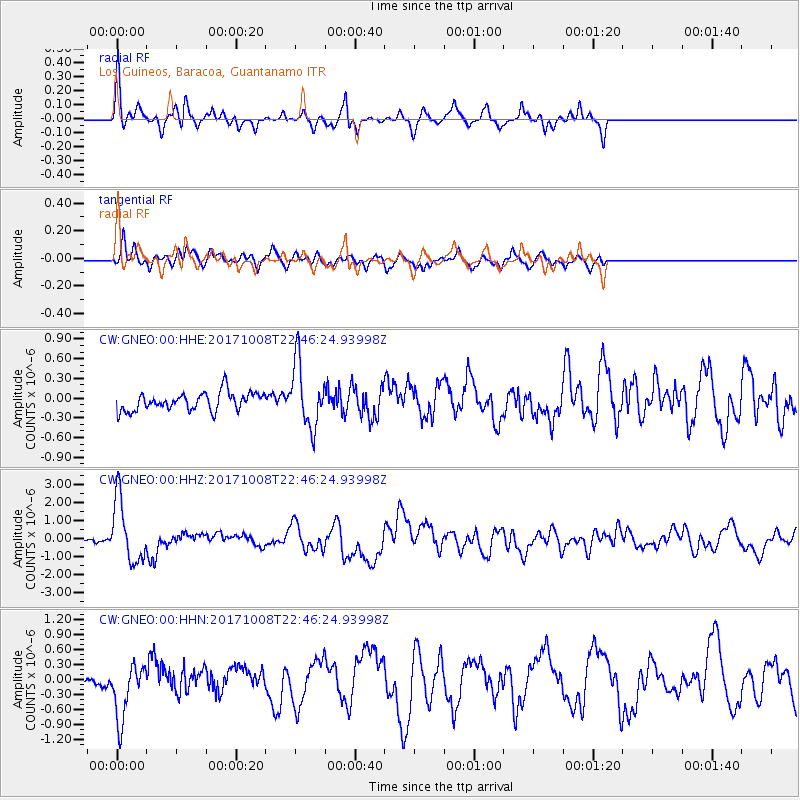
Signal To Noise
| Channel | StoN | STA | LTA |
| CW:GNEO:00:HHZ:20171008T22:46:24.93998Z | 17.730816 | 1.739782E-6 | 9.812194E-8 |
| CW:GNEO:00:HHN:20171008T22:46:24.93998Z | 6.021913 | 5.588214E-7 | 9.279798E-8 |
| CW:GNEO:00:HHE:20171008T22:46:24.93998Z | 3.513636 | 4.84577E-7 | 1.3791326E-7 |
| Arrivals |
| Ps | 12 SECOND |
| PpPs | 38 SECOND |
| PsPs/PpSs | 50 SECOND |


