
Station CW GNEO - Los Guineos, Baracoa, Guantanamo
Network: CW - Servicio Sismologico Nacional de Cuba (SSNC)
Nearby stations (2 deg radius)
| Station | Name | (Lat, Lon) | Start / End | Elevation |
| GNEO | Los Guineos, Baracoa, Guantanamo | (20.33, -74.59) | 2017-05-24 / 2599-12-31 | 558 m |
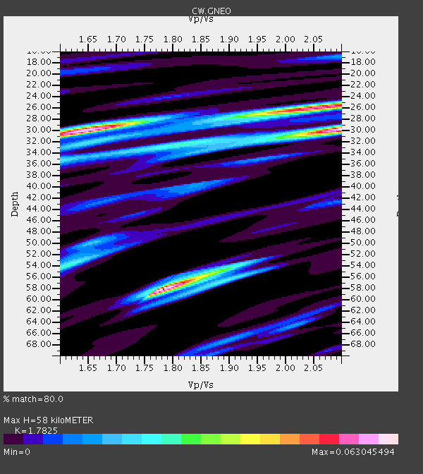
| Crust2 Type: | BC,melt affected o.c. and oceanic plateaus, 5.5 km seds. |
| Thickness Estimate: | 58 km |
| Thickness StdDev: | 14 km |
| Vp/Vs Estimate: | 1.78 |
| Vp/Vs StdDev: | 0.12 |
| Vs Estimate: | 2.842 km/s |
| Poisson's Ratio: | 0.27 |
| Peak Value: | 0.06 |
| Assumed Vp: | 5.066 km/s |
| Ps Weight: | 0.33333334 |
| PpPs Weight: | 0.33333334 |
| PsPs Weight: | 0.33333328 |
| Residual Complexity: | 0.907 |
| Nearby stations H: | +- |
| (2.0 deg) Vp/Vs: | +- |
0 with match > 90% ( 0.0 %) and 2 with match > 80% ( 9.523809 %) out of 21.
Download stack as xyz text file.
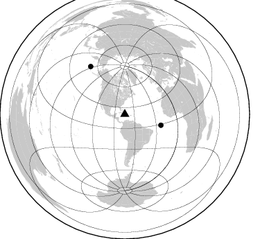
Azimuth Distribution of Events:
Prior Results for this Station
| Study | Thickness | Vp/Vs | Vp | Vs | Poissons Ratio | Extra |
| EARS | 58 km | 1.78 | 5.066 km/s | 2.842 km/s | 0.27 | |
| Crust2.0 | 21 km | 1.92 | 5.066 km/s | 2.638 km/s | 0.31 | BC,melt affected o.c. and oceanic plateaus, 5.5 km seds. |
| Global Maxima | 58 km | 1.78 | 5.066 km/s | 2.842 km/s | 0.27 | amp=0.063045494 |
| Local Maxima 1 | 30 km | 2.09 | 5.066 km/s | 2.421 km/s | 0.35 | amp=0.06226494 |
| Local Maxima 2 | 30 km | 1.65 | 5.066 km/s | 3.07 km/s | 0.21 | amp=0.061309133 |
| Local Maxima 3 | 26 km | 2.05 | 5.066 km/s | 2.468 km/s | 0.34 | amp=0.041860618 |
| Local Maxima 4 | 55 km | 1.87 | 5.066 km/s | 2.716 km/s | 0.30 | amp=0.0301692 |
| Predicted Arrivals for vertical incidence (zero ray parameter) | |
| Ps | 8.96 SECOND |
| PpPs | 31.86 SECOND |
| PsPs/PpSs | 40.82 SECOND |
Events Processed for this Station
Download zip of receiver functions as SAC
Plot maxima for each earthquake.
Events Used in the Stack
(2 events)| Radial Match | Distance | Baz | FERegion | Time | Lat/Lon | Depth | Magnitude |
| 85.699905 | 54.4 deg | 106.79 deg | Central Mid-Atlantic Ridge | 2017/11/30 06:32:52 GMT | (-1.1, -23.5) | 10 km | 6.5 Mi |
| 81.76933 | 84.8 deg | 324.379 deg | Rat Islands, Aleutian Islands | 2017/10/08 22:34:33 GMT | (52.4, 176.8) | 112 km | 6.6 mww |
Losers
(19 events)| Radial Match | Distance | Baz | FERegion | Time | Lat/Lon | Depth | Magnitude | Reason |
| 75.94849 | 71.8 deg | 2.532 deg | North Of Franz Josef Land | 2017/10/28 19:11:01 GMT | (86.9, 55.1) | 10 km | 6.0 Mww | |
| 74.02128 | 51.7 deg | 105.575 deg | Central Mid-Atlantic Ridge | 2017/10/06 02:03:48 GMT | (1.0, -25.5) | 10 km | 5.5 Mww | |
| 73.49277 | 87.9 deg | 328.164 deg | Komandorskiye Ostrova Region | 2017/07/17 23:34:21 GMT | (54.2, 169.2) | 48 km | 7.4 Mi | |
| 72.71028 | 48.9 deg | 173.126 deg | La Rioja Province, Argentina | 2017/08/01 06:13:53 GMT | (-28.6, -68.7) | 85 km | 5.6 Mww | |
| 69.61212 | 87.1 deg | 51.668 deg | Dodecanese Islands, Greece | 2017/07/20 22:31:12 GMT | (36.9, 27.5) | 10 km | 6.7 Mww | |
| 66.472305 | 67.5 deg | 112.696 deg | Ascension Island Region | 2017/11/11 00:36:14 GMT | (-11.7, -14.1) | 10 km | 6.1 Mww | |
| 66.273056 | 87.8 deg | 156.133 deg | South Sandwich Islands Region | 2017/09/04 08:07:35 GMT | (-57.8, -25.6) | 35 km | 6.0 Mww | |
| 63.537724 | 71.9 deg | 118.315 deg | Southern Mid-Atlantic Ridge | 2017/09/18 05:28:03 GMT | (-18.5, -12.7) | 10 km | 5.7 mb | |
| 56.596867 | 38.9 deg | 172.508 deg | Northern Chile | 2017/10/10 06:32:20 GMT | (-18.5, -69.6) | 82 km | 6.3 Mww | |
| 54.41279 | 47.2 deg | 28.947 deg | Reykjanes Ridge | 2017/09/01 11:07:37 GMT | (57.0, -34.0) | 10 km | 5.7 Mww | |
| 53.174572 | 71.8 deg | 2.558 deg | North Of Franz Josef Land | 2017/10/28 16:13:54 GMT | (86.9, 54.5) | 10 km | 5.8 Mww | |
| 52.097233 | 30.8 deg | 179.948 deg | Central Peru | 2017/08/13 16:51:22 GMT | (-10.7, -74.6) | 21 km | 5.6 mb | |
| 51.231094 | 47.5 deg | 29.002 deg | Reykjanes Ridge | 2017/09/10 21:40:21 GMT | (57.1, -33.7) | 10 km | 5.9 Mww | |
| 47.22882 | 67.2 deg | 325.947 deg | Kodiak Island Region, Alaska | 2017/08/31 17:46:02 GMT | (58.5, -153.7) | 62 km | 5.5 ml | |
| 41.12264 | 51.9 deg | 177.354 deg | Off Coast Of Central Chile | 2017/09/18 13:46:56 GMT | (-31.8, -72.1) | 10 km | 5.8 Mww | |
| 40.89528 | 51.8 deg | 170.136 deg | Cordoba Province, Argentina | 2017/10/12 18:59:08 GMT | (-31.0, -65.6) | 157 km | 5.5 Mww | |
| 25.681864 | 43.2 deg | 52.764 deg | Azores Islands Region | 2017/08/30 14:19:14 GMT | (40.0, -29.4) | 10 km | 5.6 Mww | |
| 25.429745 | 50.3 deg | 177.38 deg | Off Coast Of Central Chile | 2017/08/12 12:54:12 GMT | (-30.2, -72.3) | 6.6 km | 5.8 Mww | |
| 25.183163 | 95.0 deg | 210.352 deg | Pacific-Antarctic Ridge | 2017/07/18 13:04:07 GMT | (-57.0, -141.4) | 10 km | 5.7 Mww |

