You are here: Home > Network List > IC - New China Digital Seismograph Network Stations List
> Station HIA Hailar, Neimenggu Autonomous Region, China > Earthquake Result Viewer
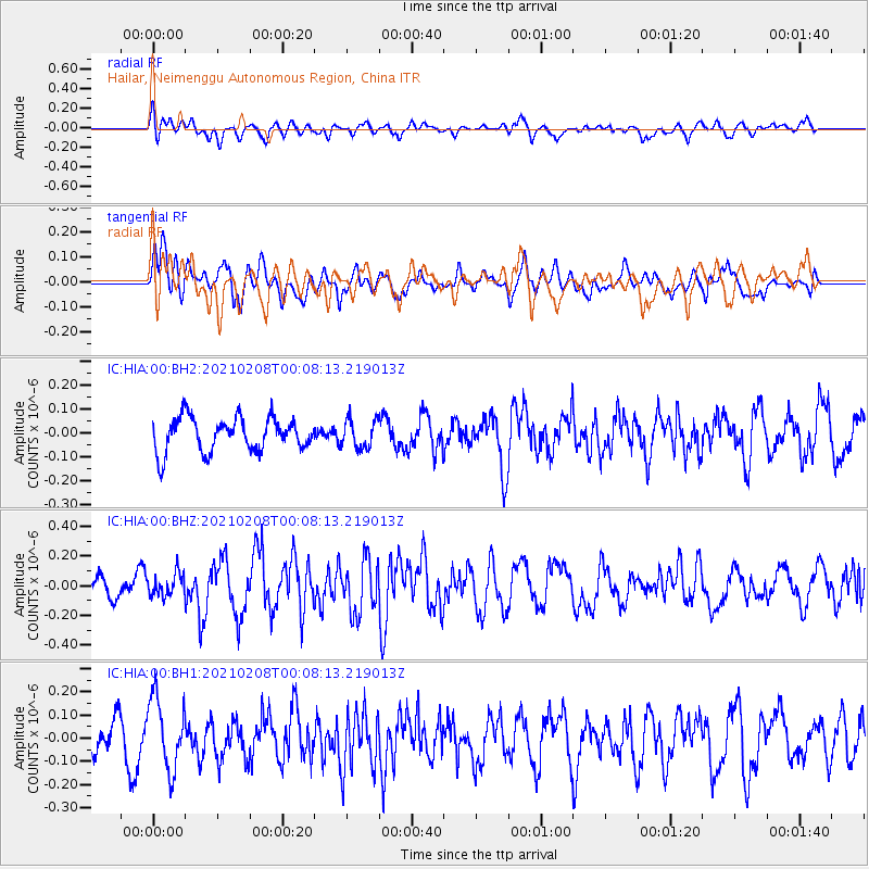
HIA Hailar, Neimenggu Autonomous Region, China - Earthquake Result Viewer
*The percent match for this event was below the threshold and hence no stack was calculated.
| Earthquake location: |
Philippine Islands Region |
| Earthquake latitude/longitude: |
5.7/127.1 |
| Earthquake time(UTC): |
2021/02/08 (039) 00:00:42 GMT |
| Earthquake Depth: |
51 km |
| Earthquake Magnitude: |
5.6 Mww |
| Earthquake Catalog/Contributor: |
NEIC PDE/us |
|
| Network: |
IC New China Digital Seismograph Network |
| Station: |
HIA Hailar, Neimenggu Autonomous Region, China |
| Lat/Lon: |
49.27 N/119.74 E |
| Elevation: |
620 m |
|
| Distance: |
43.8 deg |
| Az: |
353.09 deg |
| Baz: |
169.468 deg |
| Ray Param: |
$rayparam |
*The percent match for this event was below the threshold and hence was not used in the summary stack. |
|
| Radial Match: |
47.047955 % |
| Radial Bump: |
400 |
| Transverse Match: |
54.098526 % |
| Transverse Bump: |
400 |
| SOD ConfigId: |
23341671 |
| Insert Time: |
2021-02-22 01:05:41.833 +0000 |
| GWidth: |
2.5 |
| Max Bumps: |
400 |
| Tol: |
0.001 |
|
Signal To Noise
| Channel | StoN | STA | LTA |
| IC:HIA:00:BHZ:20210208T00:08:13.219013Z | 1.2542849 | 7.425049E-8 | 5.9197472E-8 |
| IC:HIA:00:BH1:20210208T00:08:13.219013Z | 3.2193797 | 1.5374184E-7 | 4.7755112E-8 |
| IC:HIA:00:BH2:20210208T00:08:13.219013Z | 0.84182614 | 5.984749E-8 | 7.109246E-8 |
| Arrivals |
| Ps | |
| PpPs | |
| PsPs/PpSs | |


