You are here: Home > Network List > IC - New China Digital Seismograph Network Stations List
> Station HIA Hailar, Neimenggu Autonomous Region, China > Earthquake Result Viewer
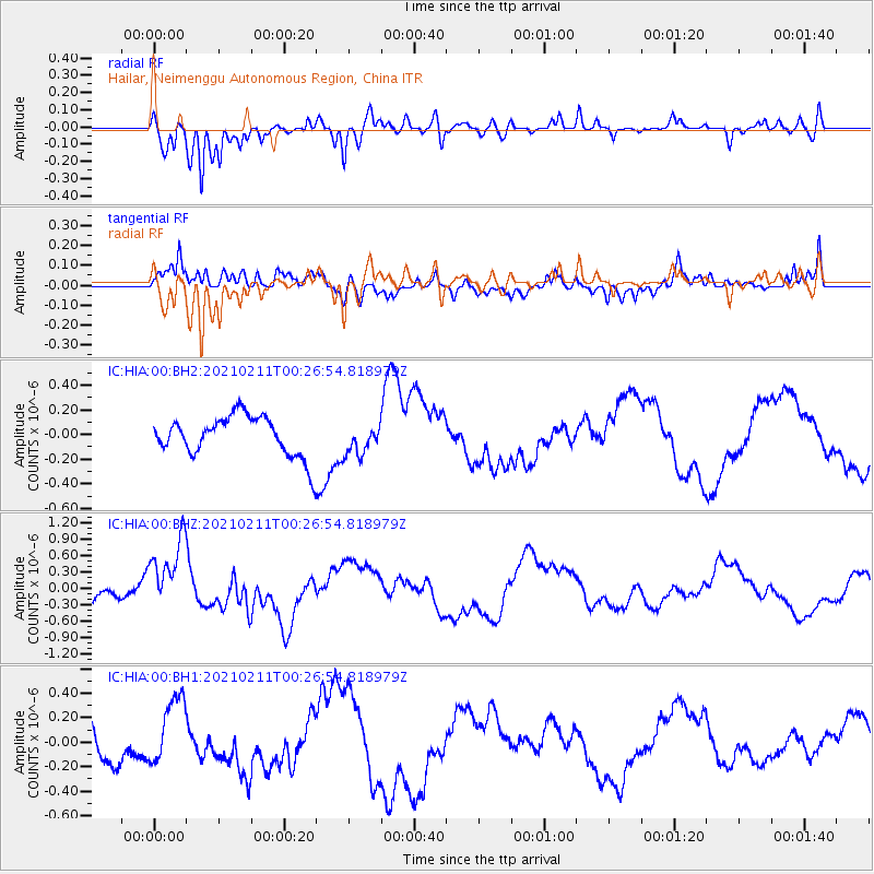
HIA Hailar, Neimenggu Autonomous Region, China - Earthquake Result Viewer
*The percent match for this event was below the threshold and hence no stack was calculated.
| Earthquake location: |
Southeast Of Loyalty Islands |
| Earthquake latitude/longitude: |
-23.2/171.7 |
| Earthquake time(UTC): |
2021/02/11 (042) 00:14:47 GMT |
| Earthquake Depth: |
10 km |
| Earthquake Magnitude: |
5.9 Mww |
| Earthquake Catalog/Contributor: |
NEIC PDE/us |
|
| Network: |
IC New China Digital Seismograph Network |
| Station: |
HIA Hailar, Neimenggu Autonomous Region, China |
| Lat/Lon: |
49.27 N/119.74 E |
| Elevation: |
620 m |
|
| Distance: |
85.7 deg |
| Az: |
328.852 deg |
| Baz: |
133.406 deg |
| Ray Param: |
$rayparam |
*The percent match for this event was below the threshold and hence was not used in the summary stack. |
|
| Radial Match: |
83.92959 % |
| Radial Bump: |
305 |
| Transverse Match: |
46.042694 % |
| Transverse Bump: |
400 |
| SOD ConfigId: |
23341671 |
| Insert Time: |
2021-02-25 01:23:47.394 +0000 |
| GWidth: |
2.5 |
| Max Bumps: |
400 |
| Tol: |
0.001 |
|
Signal To Noise
| Channel | StoN | STA | LTA |
| IC:HIA:00:BHZ:20210211T00:26:54.818979Z | 3.9710784 | 6.8596034E-7 | 1.7273906E-7 |
| IC:HIA:00:BH1:20210211T00:26:54.818979Z | 1.4246273 | 2.7591355E-7 | 1.936742E-7 |
| IC:HIA:00:BH2:20210211T00:26:54.818979Z | 0.77127993 | 1.2384847E-7 | 1.6057524E-7 |
| Arrivals |
| Ps | |
| PpPs | |
| PsPs/PpSs | |


