You are here: Home > Network List > GE - GEOFON Stations List
> Station KRIS GEOFON Station Kristallenia, Greece > Earthquake Result Viewer
KRIS GEOFON Station Kristallenia, Greece - Earthquake Result Viewer
| Earthquake location: |
Northwest Of Kuril Islands |
| Earthquake latitude/longitude: |
47.1/148.6 |
| Earthquake time(UTC): |
2001/10/03 (276) 17:25:12 GMT |
| Earthquake Depth: |
284 km |
| Earthquake Magnitude: |
5.6 MB, 5.9 MW, 5.9 MW |
| Earthquake Catalog/Contributor: |
WHDF/NEIC |
|
| Network: |
GE GEOFON |
| Station: |
KRIS GEOFON Station Kristallenia, Greece |
| Lat/Lon: |
35.18 N/25.50 E |
| Elevation: |
850 m |
|
| Distance: |
83.5 deg |
| Az: |
316.336 deg |
| Baz: |
35.171 deg |
| Ray Param: |
0.045403816 |
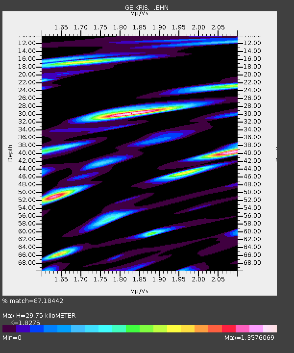
| Estimated Moho Depth: |
29.75 km |
| Estimated Crust Vp/Vs: |
1.83 |
| Assumed Crust Vp: |
5.627 km/s |
| Estimated Crust Vs: |
3.079 km/s |
| Estimated Crust Poisson's Ratio: |
0.29 |
|
| Radial Match: |
87.18442 % |
| Radial Bump: |
400 |
| Transverse Match: |
79.01123 % |
| Transverse Bump: |
400 |
| SOD ConfigId: |
20082 |
| Insert Time: |
2010-03-09 05:23:55.357 +0000 |
| GWidth: |
2.5 |
| Max Bumps: |
400 |
| Tol: |
0.001 |
|

Signal To Noise
| Channel | StoN | STA | LTA |
| GE:KRIS: :BHN:20011003T17:36:37.589011Z | 11.048378 | 1.0780475E-6 | 9.757518E-8 |
| GE:KRIS: :BHE:20011003T17:36:37.589011Z | 9.077047 | 8.35156E-7 | 9.2007454E-8 |
| GE:KRIS: :BHZ:20011003T17:36:37.589011Z | 38.158833 | 3.4131876E-6 | 8.944686E-8 |
| Arrivals |
| Ps | 4.5 SECOND |
| PpPs | 15 SECOND |
| PsPs/PpSs | 19 SECOND |


