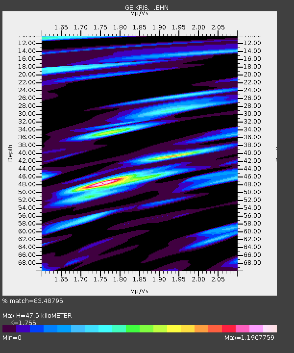
KRIS GEOFON Station Kristallenia, Greece - Earthquake Result Viewer

Earthquake location: Southern Sumatra, Indonesia
Earthquake latitude/longitude: -4.7/102.6
Earthquake time(UTC): 2001/02/13 (044) 19:28:30 GMT
Earthquake Depth: 36 km
Earthquake Magnitude: 6.2 MB, 7.2 MS, 7.4 MW, 7.0 ME
Earthquake Catalog/Contributor: WHDF/NEIC
Network: GE GEOFON
Station: KRIS GEOFON Station Kristallenia, Greece
Lat/Lon: 35.18 N/25.50 E
Elevation: 850 m
Distance: 82.2 deg
Az: 306.302 deg
Baz: 101.317 deg
Ray Param: 0.047027703
Estimated Moho Depth: 47.5 km
Estimated Crust Vp/Vs: 1.75
Assumed Crust Vp: 5.627 km/s
Estimated Crust Vs: 3.206 km/s
Estimated Crust Poisson's Ratio: 0.26
Radial Match: 83.48795 %
Radial Bump: 400
Transverse Match: 75.04482 %
Transverse Bump: 400
SOD ConfigId: 3744
Insert Time: 2010-03-09 05:23:59.177 +0000
GWidth: 2.5
Max Bumps: 400
Tol: 0.001

Signal To Noise

ChannelStoNSTALTA
GE:KRIS: :BHN:20010213T19:40:16.298025Z1.91736447.8456117E-74.091873E-7
GE:KRIS: :BHE:20010213T19:40:16.298025Z0.74398733.679435E-74.9455616E-7
GE:KRIS: :BHZ:20010213T19:40:16.298025Z1.33374187.0329924E-75.273129E-7
Arrivals
Ps6.5 SECOND
PpPs23 SECOND
PsPs/PpSs29 SECOND