You are here: Home > Network List > GS - US Geological Survey Networks Stations List
> Station ID05 Sulphur Canyon Road, Soda Springs, Idaho, USA > Earthquake Result Viewer
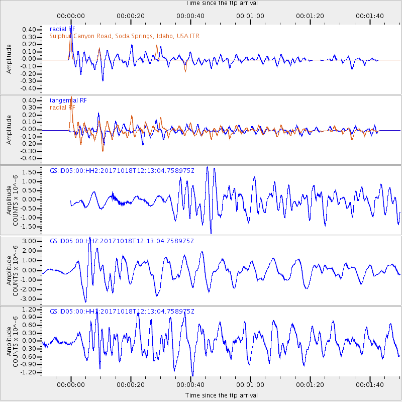
ID05 Sulphur Canyon Road, Soda Springs, Idaho, USA - Earthquake Result Viewer
| Earthquake location: |
Tonga Islands |
| Earthquake latitude/longitude: |
-20.6/-173.9 |
| Earthquake time(UTC): |
2017/10/18 (291) 12:00:59 GMT |
| Earthquake Depth: |
10 km |
| Earthquake Magnitude: |
6.0 Mww |
| Earthquake Catalog/Contributor: |
NEIC PDE/us |
|
| Network: |
GS US Geological Survey Networks |
| Station: |
ID05 Sulphur Canyon Road, Soda Springs, Idaho, USA |
| Lat/Lon: |
42.64 N/111.46 W |
| Elevation: |
2262 m |
|
| Distance: |
85.2 deg |
| Az: |
41.027 deg |
| Baz: |
236.454 deg |
| Ray Param: |
0.04494065 |
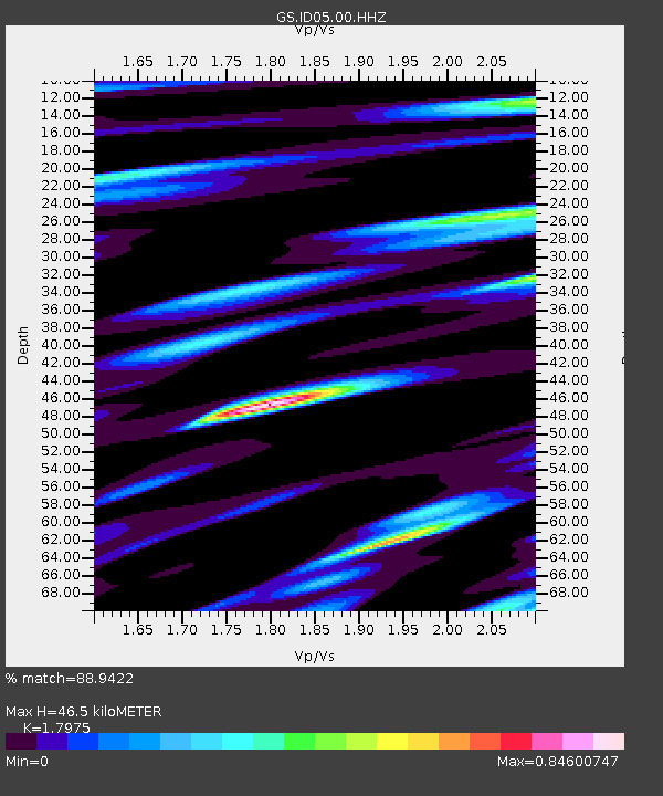
| Estimated Moho Depth: |
46.5 km |
| Estimated Crust Vp/Vs: |
1.80 |
| Assumed Crust Vp: |
6.207 km/s |
| Estimated Crust Vs: |
3.453 km/s |
| Estimated Crust Poisson's Ratio: |
0.28 |
|
| Radial Match: |
88.9422 % |
| Radial Bump: |
400 |
| Transverse Match: |
85.0572 % |
| Transverse Bump: |
400 |
| SOD ConfigId: |
2364251 |
| Insert Time: |
2017-11-01 12:04:26.498 +0000 |
| GWidth: |
2.5 |
| Max Bumps: |
400 |
| Tol: |
0.001 |
|
Signal To Noise
| Channel | StoN | STA | LTA |
| GS:ID05:00:HHZ:20171018T12:13:04.758975Z | 9.071407 | 1.1907291E-6 | 1.3126179E-7 |
| GS:ID05:00:HH1:20171018T12:13:04.758975Z | 2.5783045 | 2.2318659E-7 | 8.656332E-8 |
| GS:ID05:00:HH2:20171018T12:13:04.758975Z | 1.6328534 | 3.5226316E-7 | 2.1573472E-7 |
| Arrivals |
| Ps | 6.1 SECOND |
| PpPs | 20 SECOND |
| PsPs/PpSs | 27 SECOND |


