You are here: Home > Network List > GE - GEOFON Stations List
> Station APEZ GEOFON Station Moni Apezanon, Greece > Earthquake Result Viewer
APEZ GEOFON Station Moni Apezanon, Greece - Earthquake Result Viewer
| Earthquake location: |
Kuril Islands |
| Earthquake latitude/longitude: |
44.3/148.4 |
| Earthquake time(UTC): |
2001/05/25 (145) 00:40:50 GMT |
| Earthquake Depth: |
33 km |
| Earthquake Magnitude: |
6.1 MB, 6.7 MS, 6.7 MW, 6.6 MW |
| Earthquake Catalog/Contributor: |
WHDF/NEIC |
|
| Network: |
GE GEOFON |
| Station: |
APEZ GEOFON Station Moni Apezanon, Greece |
| Lat/Lon: |
34.98 N/24.89 E |
| Elevation: |
435 m |
|
| Distance: |
85.9 deg |
| Az: |
316.65 deg |
| Baz: |
36.91 deg |
| Ray Param: |
0.04438284 |
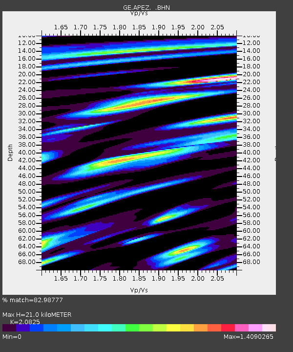
| Estimated Moho Depth: |
21.0 km |
| Estimated Crust Vp/Vs: |
2.08 |
| Assumed Crust Vp: |
5.627 km/s |
| Estimated Crust Vs: |
2.702 km/s |
| Estimated Crust Poisson's Ratio: |
0.35 |
|
| Radial Match: |
82.98777 % |
| Radial Bump: |
400 |
| Transverse Match: |
87.762115 % |
| Transverse Bump: |
400 |
| SOD ConfigId: |
4714 |
| Insert Time: |
2010-03-09 05:42:32.603 +0000 |
| GWidth: |
2.5 |
| Max Bumps: |
400 |
| Tol: |
0.001 |
|

Signal To Noise
| Channel | StoN | STA | LTA |
| GE:APEZ: :BHN:20010525T00:52:56.006006Z | 1.0290158 | 3.059712E-7 | 2.9734358E-7 |
| GE:APEZ: :BHE:20010525T00:52:56.006006Z | 1.4462351 | 2.6847954E-7 | 1.8564032E-7 |
| GE:APEZ: :BHZ:20010525T00:52:56.006006Z | 6.0832605 | 1.0054601E-6 | 1.6528308E-7 |
| Arrivals |
| Ps | 4.1 SECOND |
| PpPs | 11 SECOND |
| PsPs/PpSs | 15 SECOND |


