
Station GE APEZ - GEOFON Station Moni Apezanon, Greece
Network: GE - GEOFON
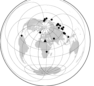
Nearby stations (2 deg radius)
| Station | Name | (Lat, Lon) | Start / End | Elevation |
| APEZ | GEOFON Station Moni Apezanon, Greece | (34.98, 24.89) | 2000-04-08 / 2499-01-01 | 435 m |
| Crust2 Type: | S5,continental slope, margin, transition 8 km seds. |
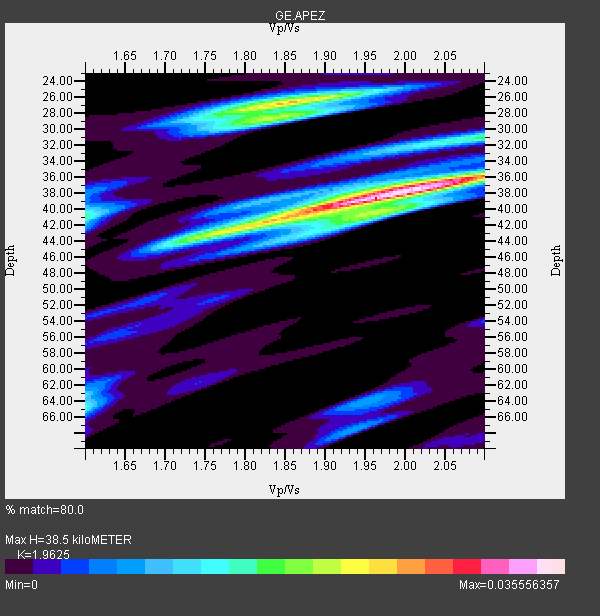
| Thickness Estimate: | 38 km |
| Thickness StdDev: | 3.2 km |
| Vp/Vs Estimate: | 1.96 |
| Vp/Vs StdDev: | 0.09 |
| Vs Estimate: | 2.867 km/s |
| Poisson's Ratio: | 0.32 |
| Peak Value: | 0.04 |
| Assumed Vp: | 5.627 km/s |
| Ps Weight: | 0.33333334 |
| PpPs Weight: | 0.33333334 |
| PsPs Weight: | 0.33333328 |
| Residual Complexity: | 0.706 |
| Nearby stations H: | +- |
| (2.0 deg) Vp/Vs: | +- |
2 with match > 90% ( 8.333333 %) and 24 with match > 80% ( 100.0 %) out of 24.
Download stack as xyz text file.
Azimuth Distribution of Events:
Prior Results for this Station
| Study | Thickness | Vp/Vs | Vp | Vs | Poissons Ratio | Extra |
| EARS | 38 km | 1.96 | 5.627 km/s | 2.867 km/s | 0.32 | |
| Crust2.0 | 28 km | 1.82 | 5.627 km/s | 3.087 km/s | 0.28 | S5,continental slope, margin, transition 8 km seds. |
| Global Maxima | 38 km | 1.96 | 5.627 km/s | 2.867 km/s | 0.32 | amp=0.035556357 |
| Local Maxima 1 | 26 km | 1.86 | 5.627 km/s | 3.029 km/s | 0.30 | amp=0.025443228 |
| Local Maxima 2 | 36 km | 2.06 | 5.627 km/s | 2.731 km/s | 0.35 | amp=0.02347704 |
| Local Maxima 3 | 42 km | 1.78 | 5.627 km/s | 3.161 km/s | 0.27 | amp=0.02080337 |
| Local Maxima 4 | 41 km | 1.60 | 5.627 km/s | 3.517 km/s | 0.18 | amp=0.015336893 |
| Predicted Arrivals for vertical incidence (zero ray parameter) | |
| Ps | 6.59 SECOND |
| PpPs | 20.27 SECOND |
| PsPs/PpSs | 26.86 SECOND |
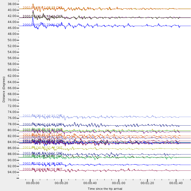
Events Processed for this Station
Download zip of receiver functions as SAC
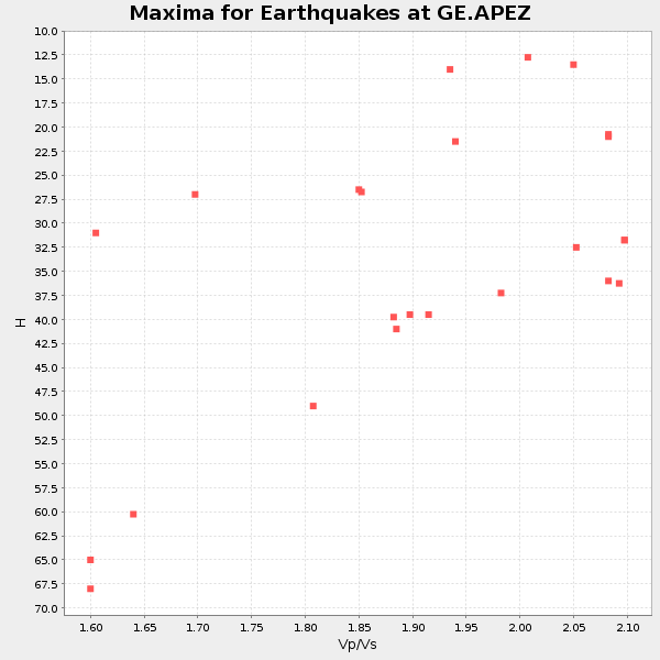
Plot maxima for each earthquake.
Events Used in the Stack
(24 events)| Radial Match | Distance | Baz | FERegion | Time | Lat/Lon | Depth | Magnitude |
| 91.12726 | 81.7 deg | 356.743 deg | Central Alaska | 2002/10/23 11:27:19 GMT | (63.5, -147.9) | 4.2 km | 6.0 MB, 6.7 MS, 6.7 MW, 6.7 MW |
| 90.34077 | 39.9 deg | 330.715 deg | Iceland | 2000/06/17 15:40:41 GMT | (64.0, -20.5) | 10 km | 5.7 MB, 6.6 MS, 6.8 MW, 6.5 MW |
| 89.74922 | 88.3 deg | 358.96 deg | Kodiak Island Region, Alaska | 2001/01/10 16:02:44 GMT | (57.1, -153.2) | 33 km | 6.2 MB, 6.8 MS, 7.1 MW, 6.8 ML |
| 87.94836 | 94.2 deg | 79.715 deg | Mindanao, Philippines | 2002/03/05 21:16:09 GMT | (6.0, 124.2) | 31 km | 6.3 MB, 7.2 MS, 7.5 MW, 7.2 MW |
| 87.06256 | 43.1 deg | 171.539 deg | Lake Tanganyika Region | 2000/10/02 02:25:31 GMT | (-8.0, 30.7) | 34 km | 6.1 MB, 6.7 MS, 6.5 MW, 6.2 ME |
| 86.678825 | 83.6 deg | 52.743 deg | Western Honshu, Japan | 2001/03/24 06:27:53 GMT | (34.1, 132.5) | 50 km | 6.4 MB, 6.5 MS, 6.8 MW, 6.4 ME |
| 86.29665 | 90.4 deg | 17.024 deg | Rat Islands, Aleutian Islands | 2003/06/15 19:24:33 GMT | (51.6, 176.9) | 20 km | 6.0 MB, 6.4 MS, 6.5 MW, 6.5 MW |
| 86.24194 | 91.4 deg | 3.556 deg | South Of Alaska | 2002/05/25 05:36:31 GMT | (53.8, -161.1) | 33 km | 5.5 MB, 6.1 MS, 6.5 MW, 6.4 MW |
| 85.87016 | 86.3 deg | 44.13 deg | Near East Coast Of Honshu, Japan | 2002/11/03 03:37:42 GMT | (38.9, 142.0) | 39 km | 5.7 MB, 6.1 MS, 6.4 MW, 6.4 MW |
| 85.49198 | 81.6 deg | 66.921 deg | Taiwan | 2000/06/10 18:23:29 GMT | (23.8, 121.2) | 33 km | 6.2 MB, 6.2 MS, 6.4 MW, 6.3 MW |
| 85.31854 | 76.6 deg | 45.791 deg | E. Russia-N.E. China Border Reg. | 2002/06/28 17:19:30 GMT | (43.8, 130.7) | 566 km | 6.7 MB, 7.3 MW, 7.3 MW |
| 84.76437 | 40.1 deg | 330.658 deg | Iceland | 2000/06/21 00:51:46 GMT | (64.0, -20.8) | 10 km | 6.1 MB, 6.6 MS, 6.5 MW, 6.4 MW |
| 84.082436 | 85.5 deg | 39.017 deg | Hokkaido, Japan Region | 2001/04/26 17:48:57 GMT | (43.1, 145.9) | 86 km | 5.7 MB, 6.0 MW, 6.0 MW |
| 83.95687 | 79.7 deg | 36.653 deg | Sakhalin, Russia | 2000/08/04 21:13:02 GMT | (48.8, 142.2) | 10 km | 6.3 MB, 7.1 MS, 6.8 MW, 6.7 MW |
| 83.04939 | 82.1 deg | 66.06 deg | Taiwan Region | 2002/03/31 06:52:50 GMT | (24.3, 122.2) | 33 km | 6.4 MB, 7.4 MS, 7.1 MW, 7.1 MW |
| 82.98777 | 85.9 deg | 36.91 deg | Kuril Islands | 2001/05/25 00:40:50 GMT | (44.3, 148.4) | 33 km | 6.1 MB, 6.7 MS, 6.7 MW, 6.6 MW |
| 82.34186 | 86.2 deg | 358.982 deg | Southern Alaska | 2000/05/19 20:34:26 GMT | (59.2, -153.1) | 80 km | 5.6 MB, 5.9 MW, 5.9 MW |
| 82.21212 | 96.3 deg | 283.065 deg | Panama-Colombia Border Region | 2000/11/08 06:59:58 GMT | (7.0, -77.8) | 17 km | 6.0 MB, 6.4 MS, 6.5 MW, 6.2 ML |
| 81.80441 | 84.5 deg | 55.726 deg | Kyushu, Japan | 2000/06/25 06:34:42 GMT | (31.2, 131.2) | 10 km | 5.8 MB, 5.7 MS, 6.2 MW, 5.9 MW |
| 81.4255 | 36.8 deg | 74.172 deg | Hindu Kush Region, Afghanistan | 2002/03/03 12:08:07 GMT | (36.4, 70.4) | 209 km | 6.3 MB |
| 80.72742 | 36.8 deg | 74.041 deg | Hindu Kush Region, Afghanistan | 2002/03/03 12:08:19 GMT | (36.5, 70.5) | 226 km | 6.6 MB, 7.4 MW, 7.3 MW |
| 80.51237 | 84.2 deg | 69.444 deg | Philippine Islands Region | 2000/07/16 03:21:45 GMT | (20.3, 122.0) | 33 km | 6.1 MB, 6.3 MS, 6.4 MW, 6.4 MW |
| 80.229 | 91.5 deg | 52.884 deg | Bonin Islands, Japan Region | 2000/08/06 07:27:12 GMT | (28.9, 139.6) | 395 km | 6.3 MB, 7.3 MW, 7.3 MW |
| 80.0703 | 86.0 deg | 36.903 deg | Kuril Islands | 2001/06/24 13:18:51 GMT | (44.2, 148.5) | 33 km | 5.8 MB, 5.7 MS, 6.0 MW |
Losers
(0 events)| Radial Match | Distance | Baz | FERegion | Time | Lat/Lon | Depth | Magnitude | Reason |
