You are here: Home > Network List > GE - GEOFON Stations List
> Station APEZ GEOFON Station Moni Apezanon, Greece > Earthquake Result Viewer
APEZ GEOFON Station Moni Apezanon, Greece - Earthquake Result Viewer
| Earthquake location: |
E. Russia-N.E. China Border Reg. |
| Earthquake latitude/longitude: |
43.8/130.7 |
| Earthquake time(UTC): |
2002/06/28 (179) 17:19:30 GMT |
| Earthquake Depth: |
566 km |
| Earthquake Magnitude: |
6.7 MB, 7.3 MW, 7.3 MW |
| Earthquake Catalog/Contributor: |
WHDF/NEIC |
|
| Network: |
GE GEOFON |
| Station: |
APEZ GEOFON Station Moni Apezanon, Greece |
| Lat/Lon: |
34.98 N/24.89 E |
| Elevation: |
435 m |
|
| Distance: |
76.6 deg |
| Az: |
305.681 deg |
| Baz: |
45.791 deg |
| Ray Param: |
0.049085457 |
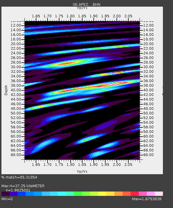
| Estimated Moho Depth: |
37.25 km |
| Estimated Crust Vp/Vs: |
1.98 |
| Assumed Crust Vp: |
5.627 km/s |
| Estimated Crust Vs: |
2.838 km/s |
| Estimated Crust Poisson's Ratio: |
0.33 |
|
| Radial Match: |
85.31854 % |
| Radial Bump: |
400 |
| Transverse Match: |
85.49977 % |
| Transverse Bump: |
400 |
| SOD ConfigId: |
20082 |
| Insert Time: |
2010-03-09 05:42:35.018 +0000 |
| GWidth: |
2.5 |
| Max Bumps: |
400 |
| Tol: |
0.001 |
|

Signal To Noise
| Channel | StoN | STA | LTA |
| GE:APEZ: :BHN:20020628T17:29:52.142009Z | 5.978781 | 2.1611063E-6 | 3.614627E-7 |
| GE:APEZ: :BHE:20020628T17:29:52.142009Z | 5.884241 | 1.8286554E-6 | 3.1077167E-7 |
| GE:APEZ: :BHZ:20020628T17:29:52.142009Z | 25.081732 | 7.3545893E-6 | 2.9322493E-7 |
| Arrivals |
| Ps | 6.6 SECOND |
| PpPs | 19 SECOND |
| PsPs/PpSs | 26 SECOND |


