You are here: Home > Network List > GE - GEOFON Stations List
> Station APEZ GEOFON Station Moni Apezanon, Greece > Earthquake Result Viewer
APEZ GEOFON Station Moni Apezanon, Greece - Earthquake Result Viewer
| Earthquake location: |
Mindanao, Philippines |
| Earthquake latitude/longitude: |
6.0/124.2 |
| Earthquake time(UTC): |
2002/03/05 (064) 21:16:09 GMT |
| Earthquake Depth: |
31 km |
| Earthquake Magnitude: |
6.3 MB, 7.2 MS, 7.5 MW, 7.2 MW |
| Earthquake Catalog/Contributor: |
WHDF/NEIC |
|
| Network: |
GE GEOFON |
| Station: |
APEZ GEOFON Station Moni Apezanon, Greece |
| Lat/Lon: |
34.98 N/24.89 E |
| Elevation: |
435 m |
|
| Distance: |
94.2 deg |
| Az: |
305.667 deg |
| Baz: |
79.715 deg |
| Ray Param: |
0.04108691 |
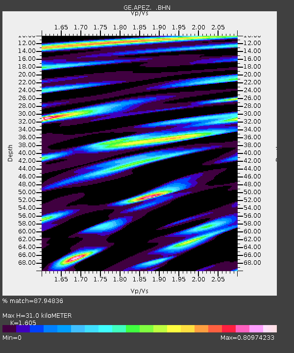
| Estimated Moho Depth: |
31.0 km |
| Estimated Crust Vp/Vs: |
1.61 |
| Assumed Crust Vp: |
5.627 km/s |
| Estimated Crust Vs: |
3.506 km/s |
| Estimated Crust Poisson's Ratio: |
0.18 |
|
| Radial Match: |
87.94836 % |
| Radial Bump: |
400 |
| Transverse Match: |
91.245995 % |
| Transverse Bump: |
400 |
| SOD ConfigId: |
20082 |
| Insert Time: |
2010-03-09 05:42:39.152 +0000 |
| GWidth: |
2.5 |
| Max Bumps: |
400 |
| Tol: |
0.001 |
|

Signal To Noise
| Channel | StoN | STA | LTA |
| GE:APEZ: :BHN:20020305T21:28:53.590022Z | 1.1014488 | 1.3256484E-7 | 1.2035497E-7 |
| GE:APEZ: :BHE:20020305T21:28:53.590022Z | 2.7288 | 2.1500705E-7 | 7.87918E-8 |
| GE:APEZ: :BHZ:20020305T21:28:53.590022Z | 11.809216 | 7.907501E-7 | 6.6960425E-8 |
| Arrivals |
| Ps | 3.4 SECOND |
| PpPs | 14 SECOND |
| PsPs/PpSs | 18 SECOND |


