You are here: Home > Network List > GE - GEOFON Stations List
> Station GVD GEOFON Station Gavdos Island, Greece > Earthquake Result Viewer
GVD GEOFON Station Gavdos Island, Greece - Earthquake Result Viewer
| Earthquake location: |
Sea Of Okhotsk |
| Earthquake latitude/longitude: |
46.8/145.4 |
| Earthquake time(UTC): |
2000/07/10 (192) 09:58:18 GMT |
| Earthquake Depth: |
360 km |
| Earthquake Magnitude: |
6.1 MB, 5.9 MW, 5.8 MW |
| Earthquake Catalog/Contributor: |
WHDF/NEIC |
|
| Network: |
GE GEOFON |
| Station: |
GVD GEOFON Station Gavdos Island, Greece |
| Lat/Lon: |
34.84 N/24.09 E |
| Elevation: |
180 m |
|
| Distance: |
83.1 deg |
| Az: |
314.954 deg |
| Baz: |
36.209 deg |
| Ray Param: |
0.045459103 |
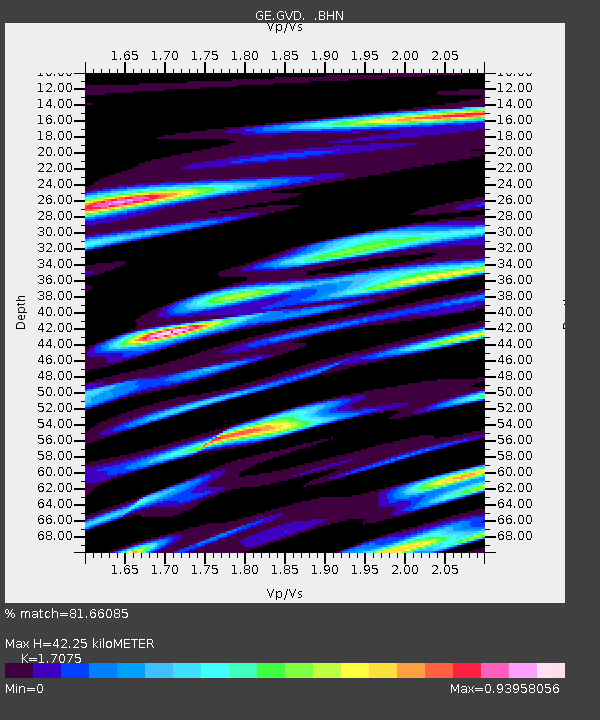
| Estimated Moho Depth: |
42.25 km |
| Estimated Crust Vp/Vs: |
1.71 |
| Assumed Crust Vp: |
5.627 km/s |
| Estimated Crust Vs: |
3.295 km/s |
| Estimated Crust Poisson's Ratio: |
0.24 |
|
| Radial Match: |
81.66085 % |
| Radial Bump: |
400 |
| Transverse Match: |
89.61089 % |
| Transverse Bump: |
361 |
| SOD ConfigId: |
3744 |
| Insert Time: |
2010-03-09 05:53:25.094 +0000 |
| GWidth: |
2.5 |
| Max Bumps: |
400 |
| Tol: |
0.001 |
|

Signal To Noise
| Channel | StoN | STA | LTA |
| GE:GVD: :BHN:20000710T10:09:34.234995Z | 1.2743038 | 1.027662E-5 | 8.064497E-6 |
| GE:GVD: :BHE:20000710T10:09:34.234995Z | 1.1653402 | 1.0289095E-5 | 8.829263E-6 |
| GE:GVD: :BHZ:20000710T10:09:34.234995Z | 1.7471474 | 4.346474E-6 | 2.4877545E-6 |
| Arrivals |
| Ps | 5.4 SECOND |
| PpPs | 20 SECOND |
| PsPs/PpSs | 25 SECOND |


