
Station GE GVD - GEOFON Station Gavdos Island, Greece
Network: GE - GEOFON
Nearby stations (2 deg radius)
| Station | Name | (Lat, Lon) | Start / End | Elevation |
| GVD | GEOFON Station Gavdos Island, Greece | (34.84, 24.09) | 2000-04-08 / 2003-09-12 | 180 m |
| GVD | GEOFON Station Gavdos Island, Greece | (34.84, 24.09) | 2003-09-12 / 2499-01-01 | 180 m |
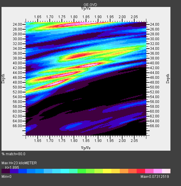
| Crust2 Type: | S5,continental slope, margin, transition 8 km seds. |
| Thickness Estimate: | 23 km |
| Thickness StdDev: | 8.4 km |
| Vp/Vs Estimate: | 1.89 |
| Vp/Vs StdDev: | 0.07 |
| Vs Estimate: | 2.969 km/s |
| Poisson's Ratio: | 0.31 |
| Peak Value: | 0.07 |
| Assumed Vp: | 5.627 km/s |
| Ps Weight: | 0.33333334 |
| PpPs Weight: | 0.33333334 |
| PsPs Weight: | 0.33333328 |
| Residual Complexity: | 0.915 |
| Nearby stations H: | +- |
| (2.0 deg) Vp/Vs: | +- |
4 with match > 90% ( 13.333333 %) and 30 with match > 80% ( 100.0 %) out of 30.
Download stack as xyz text file.
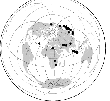
Azimuth Distribution of Events:
Prior Results for this Station
| Study | Thickness | Vp/Vs | Vp | Vs | Poissons Ratio | Extra |
| EARS | 23 km | 1.89 | 5.627 km/s | 2.969 km/s | 0.31 | |
| Crust2.0 | 28 km | 1.82 | 5.627 km/s | 3.087 km/s | 0.28 | S5,continental slope, margin, transition 8 km seds. |
| Global Maxima | 23 km | 1.89 | 5.627 km/s | 2.969 km/s | 0.31 | amp=0.07312519 |
| Local Maxima 1 | 41 km | 1.87 | 5.627 km/s | 3.013 km/s | 0.30 | amp=0.072716594 |
| Local Maxima 2 | 46 km | 1.71 | 5.627 km/s | 3.295 km/s | 0.24 | amp=0.063671716 |
| Local Maxima 3 | 36 km | 1.83 | 5.627 km/s | 3.071 km/s | 0.29 | amp=0.05521439 |
| Local Maxima 4 | 48 km | 1.72 | 5.627 km/s | 3.281 km/s | 0.24 | amp=0.054595917 |
| Predicted Arrivals for vertical incidence (zero ray parameter) | |
| Ps | 3.66 SECOND |
| PpPs | 11.83 SECOND |
| PsPs/PpSs | 15.49 SECOND |
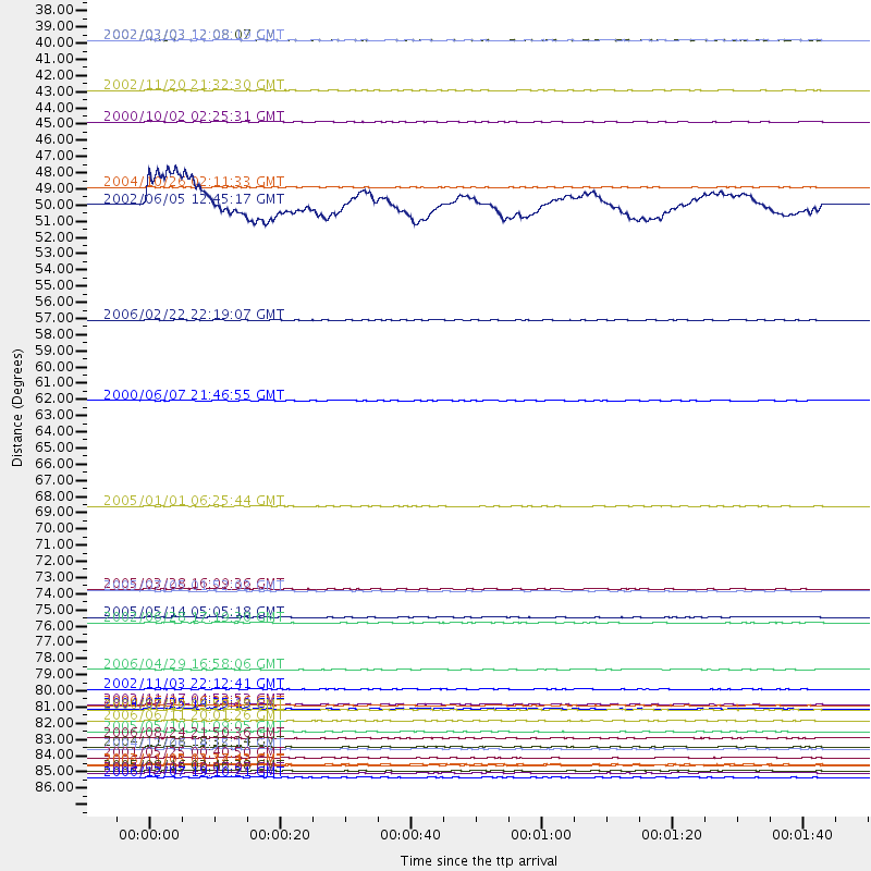
Events Processed for this Station
Download zip of receiver functions as SAC
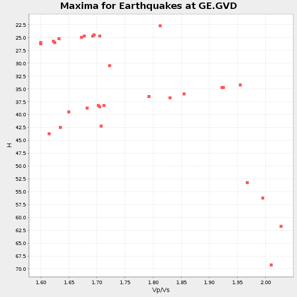
Plot maxima for each earthquake.
Events Used in the Stack
(30 events)| Radial Match | Distance | Baz | FERegion | Time | Lat/Lon | Depth | Magnitude |
| 95.95346 | 86.9 deg | 32.367 deg | Kuril Islands | 2006/11/15 11:14:13 GMT | (46.6, 153.3) | 10 km | 6.5 MB, 7.8 MS, 8.3 MW, 7.9 MW |
| 93.00278 | 74.9 deg | 98.112 deg | Northern Sumatra, Indonesia | 2005/03/28 16:09:36 GMT | (2.1, 97.1) | 30 km | 7.2 MB, 8.4 MS, 8.7 MW, 8.1 MW |
| 91.13842 | 82.9 deg | 100.75 deg | Southern Sumatra, Indonesia | 2000/06/04 16:28:26 GMT | (-4.7, 102.1) | 33 km | 6.8 MB, 8.0 MS, 7.9 MW, 7.7 MW |
| 90.261665 | 87.3 deg | 44.109 deg | Near East Coast Of Honshu, Japan | 2005/08/16 02:46:28 GMT | (38.3, 142.0) | 36 km | 6.5 MB, 6.8 MS, 7.2 MW, 7.1 MW |
| 89.817986 | 81.7 deg | 356.175 deg | Central Alaska | 2002/11/03 22:12:41 GMT | (63.5, -147.4) | 4.9 km | 7.0 MB, 8.5 MS, 7.9 MW |
| 88.197685 | 37.4 deg | 73.781 deg | Hindu Kush Region, Afghanistan | 2002/03/03 12:08:07 GMT | (36.4, 70.4) | 209 km | 6.3 MB |
| 87.65877 | 37.4 deg | 73.652 deg | Hindu Kush Region, Afghanistan | 2002/03/03 12:08:19 GMT | (36.5, 70.5) | 226 km | 6.6 MB, 7.4 MW, 7.3 MW |
| 87.304756 | 83.9 deg | 53.789 deg | Kyushu, Japan | 2006/06/11 20:01:26 GMT | (33.1, 131.1) | 140 km | 5.9 MB, 6.3 MW, 6.3 MW |
| 86.79221 | 62.1 deg | 75.423 deg | Myanmar | 2000/06/07 21:46:55 GMT | (26.9, 97.2) | 33 km | 6.3 MB, 6.5 MS, 6.4 MW, 6.4 MW |
| 86.549545 | 85.8 deg | 39.096 deg | Hokkaido, Japan Region | 2004/12/06 14:15:11 GMT | (42.9, 145.2) | 35 km | 6.5 MB, 6.5 MS, 6.8 MW, 6.8 MW |
| 86.44287 | 85.1 deg | 27.327 deg | Near East Coast Of Kamchatka | 2006/08/24 21:50:36 GMT | (51.1, 157.5) | 43 km | 5.9 MB, 6.2 MS, 6.5 MW, 6.5 MW |
| 86.07999 | 85.7 deg | 39.078 deg | Hokkaido, Japan Region | 2004/11/28 18:32:14 GMT | (43.0, 145.1) | 39 km | 6.4 MB, 6.7 MS, 7.0 MW, 7.0 MW |
| 86.0277 | 76.9 deg | 98.553 deg | Northern Sumatra, Indonesia | 2005/05/14 05:05:18 GMT | (0.6, 98.5) | 34 km | 6.4 MB, 6.8 MS, 6.8 MW, 6.8 MW |
| 84.87758 | 86.8 deg | 43.698 deg | Near East Coast Of Honshu, Japan | 2002/11/03 03:37:42 GMT | (38.9, 142.0) | 39 km | 5.7 MB, 6.1 MS, 6.4 MW, 6.4 MW |
| 84.80222 | 87.8 deg | 32.045 deg | East Of Kuril Islands | 2006/12/07 19:10:21 GMT | (46.2, 154.4) | 16 km | 6.3 MB, 6.1 MS, 6.3 MW, 6.3 MW |
| 84.751656 | 86.4 deg | 36.485 deg | Kuril Islands | 2001/05/25 00:40:50 GMT | (44.3, 148.4) | 33 km | 6.1 MB, 6.7 MS, 6.7 MW, 6.6 MW |
| 84.52233 | 77.2 deg | 45.42 deg | E. Russia-N.E. China Border Reg. | 2002/06/28 17:19:30 GMT | (43.8, 130.7) | 566 km | 6.7 MB, 7.3 MW, 7.3 MW |
| 84.225876 | 69.3 deg | 98.461 deg | Off W Coast Of Northern Sumatra | 2005/01/01 06:25:44 GMT | (5.1, 92.3) | 12 km | 6.0 MB, 6.7 MS, 6.6 MW, 6.5 MW |
| 83.54976 | 56.6 deg | 169.38 deg | Mozambique | 2006/02/22 22:19:07 GMT | (-21.3, 33.6) | 11 km | 6.5 MB, 7.5 MS, 7.0 MW, 7.0 MW |
| 83.499054 | 80.4 deg | 17.408 deg | Eastern Siberia, Russia | 2006/04/29 16:58:06 GMT | (60.5, 167.5) | 11 km | 6.4 MB, 6.6 MS, 6.6 MW, 6.4 MW |
| 83.12683 | 47.5 deg | 77.751 deg | Xizang | 2004/10/26 02:11:33 GMT | (31.0, 81.2) | 10 km | 6.0 MB, 5.4 MS, 5.7 MW, 5.5 MW |
| 83.08969 | 87.5 deg | 50.927 deg | Near S. Coast Of Western Honshu | 2004/09/05 10:07:07 GMT | (33.1, 136.6) | 14 km | 6.7 MB, 7.0 MS, 7.2 MW, 7.0 MW |
| 83.0347 | 84.6 deg | 101.354 deg | Southwest Of Sumatra, Indonesia | 2005/05/10 01:09:05 GMT | (-6.2, 103.1) | 17 km | 5.9 MB, 6.4 MS, 6.2 MW, 6.2 MW |
| 82.798515 | 83.1 deg | 97.775 deg | Southern Sumatra, Indonesia | 2004/07/25 14:35:19 GMT | (-2.4, 104.0) | 582 km | 6.8 MB, 7.3 MW, 7.3 MW |
| 81.66085 | 83.1 deg | 36.209 deg | Sea Of Okhotsk | 2000/07/10 09:58:18 GMT | (46.8, 145.4) | 360 km | 6.1 MB, 5.9 MW, 5.8 MW |
| 81.53237 | 75.0 deg | 98.351 deg | Northern Sumatra, Indonesia | 2005/07/05 01:52:02 GMT | (1.8, 97.1) | 21 km | 6.2 MB, 6.8 MS, 6.7 MW, 6.6 MW |
| 81.39364 | 43.0 deg | 170.367 deg | Lake Tanganyika Region | 2000/10/02 02:25:31 GMT | (-8.0, 30.7) | 34 km | 6.1 MB, 6.7 MS, 6.5 MW, 6.2 ME |
| 80.35636 | 82.8 deg | 35.119 deg | Northwest Of Kuril Islands | 2002/11/17 04:53:53 GMT | (47.8, 146.2) | 459 km | 7.3 MW, 7.3 MW |
| 80.081055 | 40.9 deg | 74.163 deg | Northwestern Kashmir | 2002/11/20 21:32:30 GMT | (35.4, 74.5) | 33 km | 5.7 MB, 6.5 MS, 6.4 MW, 6.0 MW |
| 80.06102 | 48.7 deg | 289.105 deg | Northern Mid-Atlantic Ridge | 2002/06/05 12:45:17 GMT | (35.5, -36.3) | 10 km | 5.2 MB, 5.1 MS, 5.7 MW, 5.6 MW |
Losers
(0 events)| Radial Match | Distance | Baz | FERegion | Time | Lat/Lon | Depth | Magnitude | Reason |
