You are here: Home > Network List > GE - GEOFON Stations List
> Station GVD GEOFON Station Gavdos Island, Greece > Earthquake Result Viewer
GVD GEOFON Station Gavdos Island, Greece - Earthquake Result Viewer
| Earthquake location: |
Northwest Of Kuril Islands |
| Earthquake latitude/longitude: |
47.8/146.2 |
| Earthquake time(UTC): |
2002/11/17 (321) 04:53:53 GMT |
| Earthquake Depth: |
459 km |
| Earthquake Magnitude: |
7.3 MW, 7.3 MW |
| Earthquake Catalog/Contributor: |
WHDF/NEIC |
|
| Network: |
GE GEOFON |
| Station: |
GVD GEOFON Station Gavdos Island, Greece |
| Lat/Lon: |
34.84 N/24.09 E |
| Elevation: |
180 m |
|
| Distance: |
82.8 deg |
| Az: |
315.398 deg |
| Baz: |
35.119 deg |
| Ray Param: |
0.045356262 |
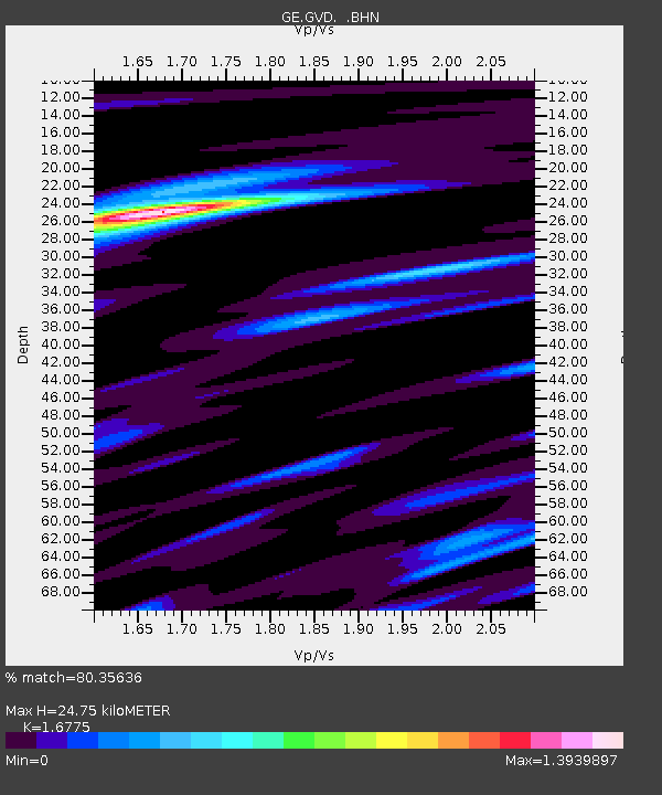
| Estimated Moho Depth: |
24.75 km |
| Estimated Crust Vp/Vs: |
1.68 |
| Assumed Crust Vp: |
5.627 km/s |
| Estimated Crust Vs: |
3.354 km/s |
| Estimated Crust Poisson's Ratio: |
0.22 |
|
| Radial Match: |
80.35636 % |
| Radial Bump: |
400 |
| Transverse Match: |
66.976 % |
| Transverse Bump: |
400 |
| SOD ConfigId: |
4714 |
| Insert Time: |
2010-03-09 05:53:32.501 +0000 |
| GWidth: |
2.5 |
| Max Bumps: |
400 |
| Tol: |
0.001 |
|

Signal To Noise
| Channel | StoN | STA | LTA |
| GE:GVD: :BHN:20021117T05:04:57.331016Z | 60.16736 | 7.2422963E-6 | 1.203692E-7 |
| GE:GVD: :BHE:20021117T05:04:57.331016Z | 34.2388 | 4.659233E-6 | 1.360805E-7 |
| GE:GVD: :BHZ:20021117T05:04:57.331016Z | 323.50305 | 2.6567024E-5 | 8.2122945E-8 |
| Arrivals |
| Ps | 3.0 SECOND |
| PpPs | 12 SECOND |
| PsPs/PpSs | 15 SECOND |


