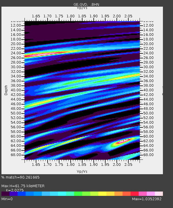
GVD GEOFON Station Gavdos Island, Greece - Earthquake Result Viewer

Earthquake location: Near East Coast Of Honshu, Japan
Earthquake latitude/longitude: 38.3/142.0
Earthquake time(UTC): 2005/08/16 (228) 02:46:28 GMT
Earthquake Depth: 36 km
Earthquake Magnitude: 6.5 MB, 6.8 MS, 7.2 MW, 7.1 MW
Earthquake Catalog/Contributor: WHDF/NEIC
Network: GE GEOFON
Station: GVD GEOFON Station Gavdos Island, Greece
Lat/Lon: 34.84 N/24.09 E
Elevation: 180 m
Distance: 87.3 deg
Az: 313.33 deg
Baz: 44.109 deg
Ray Param: 0.043384176
Estimated Moho Depth: 61.75 km
Estimated Crust Vp/Vs: 2.03
Assumed Crust Vp: 5.627 km/s
Estimated Crust Vs: 2.775 km/s
Estimated Crust Poisson's Ratio: 0.34
Radial Match: 90.261665 %
Radial Bump: 400
Transverse Match: 80.12405 %
Transverse Bump: 400
SOD ConfigId: 2475
Insert Time: 2010-03-09 05:53:50.917 +0000
GWidth: 2.5
Max Bumps: 400
Tol: 0.001

Signal To Noise

ChannelStoNSTALTA
GE:GVD: :BHN:20050816T02:58:40.139014Z3.53385522.8699608E-68.121331E-7
GE:GVD: :BHE:20050816T02:58:40.139014Z0.78807591.6461548E-62.0888278E-6
GE:GVD: :BHZ:20050816T02:58:40.150Z27.7822429.169972E-63.3006594E-7
Arrivals
Ps11 SECOND
PpPs33 SECOND
PsPs/PpSs44 SECOND