You are here: Home > Network List > XW97 - Tien Shan Continental Dynamics Stations List
> Station DGE XW.DGE > Earthquake Result Viewer
DGE XW.DGE - Earthquake Result Viewer
| Earthquake location: |
Southeast Of Honshu, Japan |
| Earthquake latitude/longitude: |
30.5/137.7 |
| Earthquake time(UTC): |
2000/06/09 (161) 22:35:13 GMT |
| Earthquake Depth: |
473 km |
| Earthquake Magnitude: |
5.4 MB, 5.9 MW, 5.8 MW |
| Earthquake Catalog/Contributor: |
WHDF/NEIC |
|
| Network: |
XW Tien Shan Continental Dynamics |
| Station: |
DGE XW.DGE |
| Lat/Lon: |
40.99 N/74.47 E |
| Elevation: |
2941 m |
|
| Distance: |
51.4 deg |
| Az: |
300.112 deg |
| Baz: |
80.587 deg |
| Ray Param: |
0.06543768 |
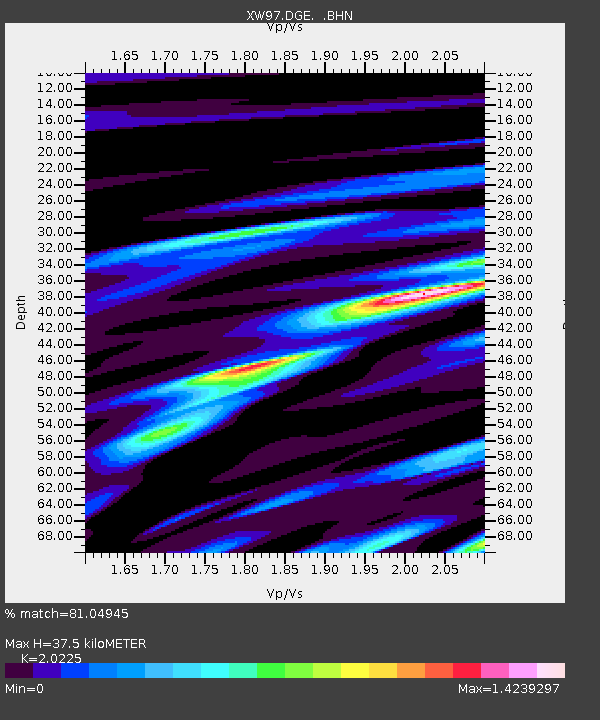
| Estimated Moho Depth: |
37.5 km |
| Estimated Crust Vp/Vs: |
2.02 |
| Assumed Crust Vp: |
6.491 km/s |
| Estimated Crust Vs: |
3.209 km/s |
| Estimated Crust Poisson's Ratio: |
0.34 |
|
| Radial Match: |
81.04945 % |
| Radial Bump: |
400 |
| Transverse Match: |
55.77104 % |
| Transverse Bump: |
400 |
| SOD ConfigId: |
20082 |
| Insert Time: |
2010-02-26 15:22:03.275 +0000 |
| GWidth: |
2.5 |
| Max Bumps: |
400 |
| Tol: |
0.001 |
|

Signal To Noise
| Channel | StoN | STA | LTA |
| XW:DGE: :BHN:20000609T22:43:02.898011Z | 1.920043 | 5.7741875E-7 | 3.007322E-7 |
| XW:DGE: :BHE:20000609T22:43:02.898011Z | 6.4626374 | 7.0412597E-7 | 1.0895335E-7 |
| XW:DGE: :BHZ:20000609T22:43:02.898011Z | 11.101336 | 1.5278443E-6 | 1.3762708E-7 |
| Arrivals |
| Ps | 6.2 SECOND |
| PpPs | 17 SECOND |
| PsPs/PpSs | 23 SECOND |


