
Station XW DGE - XW.DGE
Network: XW97 - Tien Shan Continental Dynamics
Nearby stations (2 deg radius)
| Station | Name | (Lat, Lon) | Start / End | Elevation |
| DGE | XW.DGE | (40.99, 74.47) | 1998-09-06 / 2002-01-01 | 2941 m |
| Crust2 Type: | R4,orogen/55km Tibet Transition, 0 km seds. |
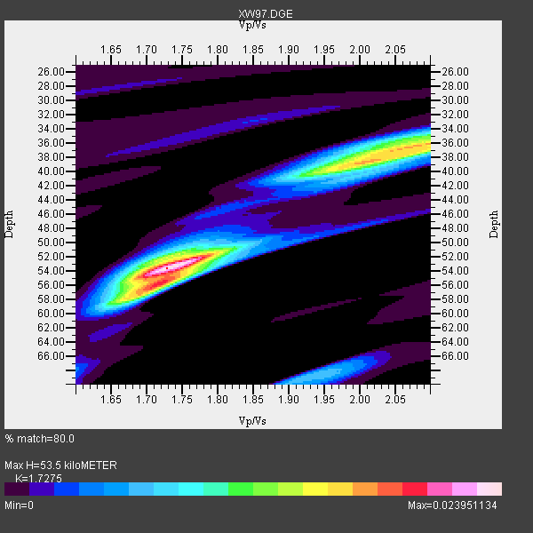
| Thickness Estimate: | 54 km |
| Thickness StdDev: | 7.4 km |
| Vp/Vs Estimate: | 1.73 |
| Vp/Vs StdDev: | 0.15 |
| Vs Estimate: | 3.757 km/s |
| Poisson's Ratio: | 0.25 |
| Peak Value: | 0.02 |
| Assumed Vp: | 6.491 km/s |
| Ps Weight: | 0.33333334 |
| PpPs Weight: | 0.33333334 |
| PsPs Weight: | 0.33333328 |
| Residual Complexity: | 0.690 |
| Nearby stations H: | +- |
| (2.0 deg) Vp/Vs: | +- |
8 with match > 90% ( 34.782608 %) and 23 with match > 80% ( 100.0 %) out of 23.
Download stack as xyz text file.
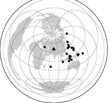
Azimuth Distribution of Events:
Prior Results for this Station
| Study | Thickness | Vp/Vs | Vp | Vs | Poissons Ratio | Extra |
| EARS | 54 km | 1.73 | 6.491 km/s | 3.757 km/s | 0.25 | |
| Crust2.0 | 55 km | 1.76 | 6.491 km/s | 3.696 km/s | 0.26 | R4,orogen/55km Tibet Transition, 0 km seds. |
| Global Maxima | 54 km | 1.73 | 6.491 km/s | 3.757 km/s | 0.25 | amp=0.023951134 |
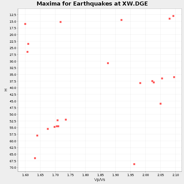
| Local Maxima 1 | 36 km | 2.07 | 6.491 km/s | 3.136 km/s | 0.35 | amp=0.016620072 |
| Local Maxima 2 | 56 km | 1.71 | 6.491 km/s | 3.796 km/s | 0.24 | amp=0.014828918 |
| Local Maxima 3 | 40 km | 1.97 | 6.491 km/s | 3.295 km/s | 0.33 | amp=0.012107614 |
| Local Maxima 4 | 68 km | 1.94 | 6.491 km/s | 3.342 km/s | 0.32 | amp=0.006842397 |
| Predicted Arrivals for vertical incidence (zero ray parameter) | |
| Ps | 6.00 SECOND |
| PpPs | 22.48 SECOND |
| PsPs/PpSs | 28.48 SECOND |
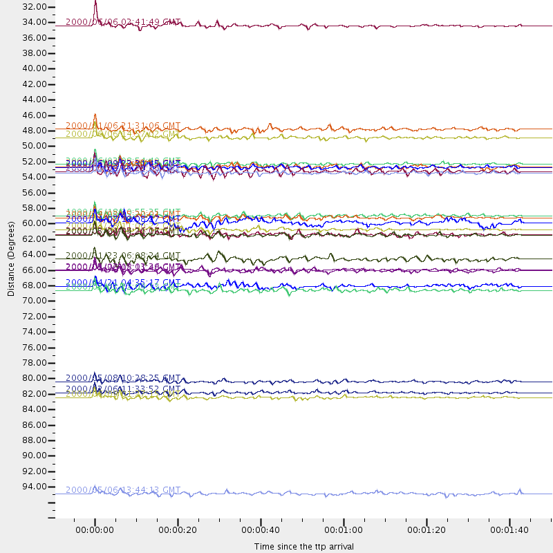
Events Processed for this Station
Download zip of receiver functions as SAC
Plot maxima for each earthquake.
Events Used in the Stack
(23 events)| Radial Match | Distance | Baz | FERegion | Time | Lat/Lon | Depth | Magnitude |
| 97.069374 | 60.3 deg | 85.255 deg | Volcano Islands, Japan Region | 2000/03/28 11:00:22 GMT | (22.3, 143.7) | 126 km | 6.8 MB, 7.6 MS, 7.6 MW, 7.6 MW |
| 94.79748 | 83.6 deg | 103.342 deg | New Britain Region, P.N.G. | 2000/02/06 11:33:52 GMT | (-5.8, 150.9) | 33 km | 6.6 MB, 6.8 MS, 6.6 MW, 6.3 ME |
| 94.75626 | 52.2 deg | 62.107 deg | Kuril Islands | 2000/01/28 14:21:07 GMT | (43.0, 146.8) | 61 km | 6.7 MB, 6.6 MS, 6.8 MW, 6.8 ME |
| 92.57337 | 51.0 deg | 73.442 deg | Near East Coast Of Honshu, Japan | 2000/06/03 08:54:49 GMT | (35.6, 140.5) | 62 km | 5.6 MB, 5.6 MS, 6.1 MW, 6.1 MW |
| 92.44318 | 84.3 deg | 101.683 deg | New Britain Region, P.N.G. | 2000/06/09 01:27:15 GMT | (-5.1, 152.5) | 33 km | 5.4 MB, 6.3 MS, 6.3 MW, 6.3 MW |
| 91.88068 | 82.1 deg | 102.903 deg | New Britain Region, P.N.G. | 2000/05/08 10:28:25 GMT | (-4.5, 150.0) | 502 km | 5.7 MB, 6.1 MW, 6.1 MW |
| 91.63113 | 31.2 deg | 283.345 deg | Turkey | 2000/06/06 02:41:49 GMT | (40.7, 33.0) | 10 km | 5.5 MB, 6.1 MS, 6.1 MW, 6.0 MW |
| 90.789825 | 51.4 deg | 80.54 deg | Southeast Of Honshu, Japan | 2000/06/09 23:31:45 GMT | (30.5, 137.7) | 485 km | 5.9 MB, 6.3 MW, 6.2 MW |
| 88.92821 | 47.2 deg | 85.375 deg | Southeast Of Ryukyu Islands | 2000/06/06 14:57:02 GMT | (29.4, 131.4) | 33 km | 5.8 MB, 6.0 MS, 6.4 MW, 6.4 MW |
| 88.74743 | 61.1 deg | 120.331 deg | Sulawesi, Indonesia | 2000/05/04 04:21:16 GMT | (-1.1, 123.6) | 26 km | 6.7 MB, 7.5 MS, 7.6 MW, 7.5 ME |
| 88.56636 | 58.4 deg | 112.56 deg | Mindanao, Philippines | 1999/06/18 10:55:25 GMT | (5.5, 126.6) | 33 km | 6.1 MB, 6.1 MS, 6.4 MW, 6.4 MW |
| 88.47827 | 46.0 deg | 109.099 deg | Luzon, Philippines | 2000/01/06 21:31:06 GMT | (16.1, 119.5) | 33 km | 5.8 MB, 5.9 MS, 6.3 MW, 6.2 MW |
| 87.21811 | 66.1 deg | 87.265 deg | Mariana Islands Region | 2000/05/02 15:03:36 GMT | (17.4, 147.5) | 55 km | 5.8 MB, 5.9 MW, 5.9 MW |
| 86.352615 | 64.6 deg | 127.73 deg | Flores Sea | 2000/01/23 06:08:24 GMT | (-8.0, 120.6) | 47 km | 5.7 MB, 5.2 MS, 5.8 MW, 5.7 MW |
| 85.91695 | 52.0 deg | 144.127 deg | Southern Sumatra, Indonesia | 2000/06/04 16:28:26 GMT | (-4.7, 102.1) | 33 km | 6.8 MB, 8.0 MS, 7.9 MW, 7.7 MW |
| 83.60645 | 98.0 deg | 97.926 deg | Santa Cruz Islands | 2000/05/06 13:44:13 GMT | (-11.3, 165.4) | 12 km | 6.0 MB, 6.3 MS, 6.3 MW, 5.8 ME |
| 81.709984 | 69.0 deg | 120.698 deg | Banda Sea | 2000/03/03 22:09:13 GMT | (-7.3, 128.5) | 142 km | 6.4 MB, 5.8 MS, 6.3 MW, 6.3 MW |
| 81.17681 | 58.7 deg | 114.585 deg | Talaud Islands, Indonesia | 2000/04/03 15:20:01 GMT | (4.1, 125.6) | 150 km | 5.9 MB, 6.2 MW, 6.0 MW |
| 81.04945 | 51.4 deg | 80.587 deg | Southeast Of Honshu, Japan | 2000/06/09 22:35:13 GMT | (30.5, 137.7) | 473 km | 5.4 MB, 5.9 MW, 5.8 MW |
| 80.2848 | 59.3 deg | 189.913 deg | Mauritius - Reunion Region | 2000/04/07 19:08:27 GMT | (-18.0, 65.5) | 10 km | 5.5 MB, 5.9 MS, 6.3 MW, 6.2 MW |
| 80.27265 | 68.4 deg | 39.981 deg | Andreanof Islands, Aleutian Is. | 2000/04/21 04:35:17 GMT | (51.4, -178.1) | 33 km | 6.0 MB, 5.7 MS, 6.2 ML, 6.0 MW |
| 80.022675 | 61.0 deg | 113.307 deg | North Of Halmahera, Indonesia | 2000/03/21 05:26:07 GMT | (3.2, 128.0) | 103 km | 6.1 MB, 5.3 MS, 6.0 MW, 5.9 MW |
| 80.01102 | 66.3 deg | 92.158 deg | Mariana Islands | 2000/02/26 08:11:48 GMT | (13.8, 144.8) | 132 km | 6.0 MB, 5.4 MS, 6.2 MW, 6.2 MW |
Losers
(0 events)| Radial Match | Distance | Baz | FERegion | Time | Lat/Lon | Depth | Magnitude | Reason |
