You are here: Home > Network List > XW97 - Tien Shan Continental Dynamics Stations List
> Station DGE XW.DGE > Earthquake Result Viewer
DGE XW.DGE - Earthquake Result Viewer
| Earthquake location: |
Mariana Islands Region |
| Earthquake latitude/longitude: |
17.4/147.5 |
| Earthquake time(UTC): |
2000/05/02 (123) 15:03:36 GMT |
| Earthquake Depth: |
55 km |
| Earthquake Magnitude: |
5.8 MB, 5.9 MW, 5.9 MW |
| Earthquake Catalog/Contributor: |
WHDF/NEIC |
|
| Network: |
XW Tien Shan Continental Dynamics |
| Station: |
DGE XW.DGE |
| Lat/Lon: |
40.99 N/74.47 E |
| Elevation: |
2941 m |
|
| Distance: |
66.1 deg |
| Az: |
307.615 deg |
| Baz: |
87.265 deg |
| Ray Param: |
0.057725806 |
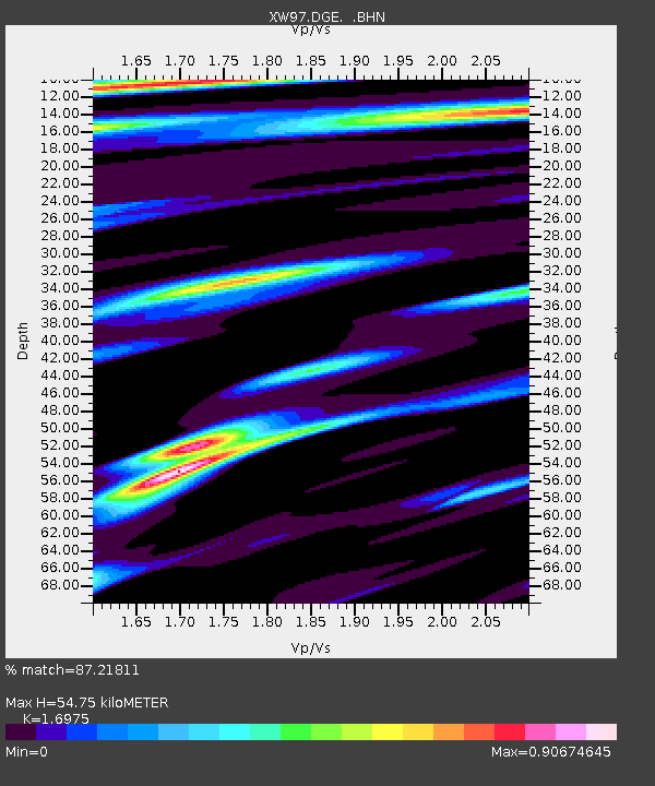
| Estimated Moho Depth: |
54.75 km |
| Estimated Crust Vp/Vs: |
1.70 |
| Assumed Crust Vp: |
6.491 km/s |
| Estimated Crust Vs: |
3.824 km/s |
| Estimated Crust Poisson's Ratio: |
0.23 |
|
| Radial Match: |
87.21811 % |
| Radial Bump: |
400 |
| Transverse Match: |
44.734097 % |
| Transverse Bump: |
400 |
| SOD ConfigId: |
20082 |
| Insert Time: |
2010-02-26 15:22:18.175 +0000 |
| GWidth: |
2.5 |
| Max Bumps: |
400 |
| Tol: |
0.001 |
|

Signal To Noise
| Channel | StoN | STA | LTA |
| XW:DGE: :BHN:20000502T15:13:47.300Z | 0.49367854 | 1.7068938E-7 | 3.4575004E-7 |
| XW:DGE: :BHE:20000502T15:13:47.300Z | 2.7663114 | 7.377855E-8 | 2.667037E-8 |
| XW:DGE: :BHZ:20000502T15:13:47.300Z | 3.9194715 | 1.7521349E-7 | 4.4703345E-8 |
| Arrivals |
| Ps | 6.1 SECOND |
| PpPs | 22 SECOND |
| PsPs/PpSs | 28 SECOND |


