You are here: Home > Network List > XW97 - Tien Shan Continental Dynamics Stations List
> Station DGE XW.DGE > Earthquake Result Viewer
DGE XW.DGE - Earthquake Result Viewer
| Earthquake location: |
Mindanao, Philippines |
| Earthquake latitude/longitude: |
5.5/126.6 |
| Earthquake time(UTC): |
1999/06/18 (169) 10:55:25 GMT |
| Earthquake Depth: |
33 km |
| Earthquake Magnitude: |
6.1 MB, 6.1 MS, 6.4 MW, 6.4 MW |
| Earthquake Catalog/Contributor: |
WHDF/NEIC |
|
| Network: |
XW Tien Shan Continental Dynamics |
| Station: |
DGE XW.DGE |
| Lat/Lon: |
40.99 N/74.47 E |
| Elevation: |
2941 m |
|
| Distance: |
58.4 deg |
| Az: |
315.387 deg |
| Baz: |
112.56 deg |
| Ray Param: |
0.062836535 |
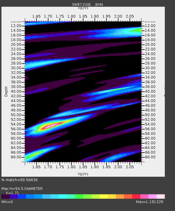
| Estimated Moho Depth: |
54.5 km |
| Estimated Crust Vp/Vs: |
1.71 |
| Assumed Crust Vp: |
6.491 km/s |
| Estimated Crust Vs: |
3.796 km/s |
| Estimated Crust Poisson's Ratio: |
0.24 |
|
| Radial Match: |
88.56636 % |
| Radial Bump: |
400 |
| Transverse Match: |
84.249306 % |
| Transverse Bump: |
400 |
| SOD ConfigId: |
4480 |
| Insert Time: |
2010-02-26 15:22:45.105 +0000 |
| GWidth: |
2.5 |
| Max Bumps: |
400 |
| Tol: |
0.001 |
|

Signal To Noise
| Channel | StoN | STA | LTA |
| XW:DGE: :BHN:19990618T11:04:47.025024Z | 15.7812195 | 1.1127062E-6 | 7.050825E-8 |
| XW:DGE: :BHE:19990618T11:04:47.025024Z | 3.919463 | 2.4510328E-7 | 6.2534916E-8 |
| XW:DGE: :BHZ:19990618T11:04:47.025024Z | 7.1183066 | 3.7698652E-7 | 5.2960143E-8 |
| Arrivals |
| Ps | 6.3 SECOND |
| PpPs | 22 SECOND |
| PsPs/PpSs | 28 SECOND |


