You are here: Home > Network List > IC - New China Digital Seismograph Network Stations List
> Station HIA Hailar, Neimenggu Autonomous Region, China > Earthquake Result Viewer
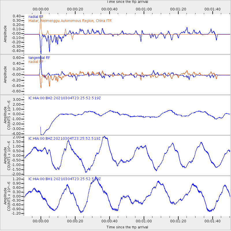
HIA Hailar, Neimenggu Autonomous Region, China - Earthquake Result Viewer
*The percent match for this event was below the threshold and hence no stack was calculated.
| Earthquake location: |
Kermadec Islands Region |
| Earthquake latitude/longitude: |
-28.5/-176.6 |
| Earthquake time(UTC): |
2021/03/04 (063) 23:12:57 GMT |
| Earthquake Depth: |
10 km |
| Earthquake Magnitude: |
6.2 mb |
| Earthquake Catalog/Contributor: |
NEIC PDE/us |
|
| Network: |
IC New China Digital Seismograph Network |
| Station: |
HIA Hailar, Neimenggu Autonomous Region, China |
| Lat/Lon: |
49.27 N/119.74 E |
| Elevation: |
620 m |
|
| Distance: |
95.9 deg |
| Az: |
323.843 deg |
| Baz: |
127.537 deg |
| Ray Param: |
$rayparam |
*The percent match for this event was below the threshold and hence was not used in the summary stack. |
|
| Radial Match: |
54.583817 % |
| Radial Bump: |
279 |
| Transverse Match: |
49.70119 % |
| Transverse Bump: |
307 |
| SOD ConfigId: |
23341671 |
| Insert Time: |
2021-03-19 00:28:43.787 +0000 |
| GWidth: |
2.5 |
| Max Bumps: |
400 |
| Tol: |
0.001 |
|
Signal To Noise
| Channel | StoN | STA | LTA |
| IC:HIA:00:BHZ:20210304T23:25:52.519Z | 1.2782109 | 1.0347133E-6 | 8.095012E-7 |
| IC:HIA:00:BH1:20210304T23:25:52.519Z | 1.2945728 | 4.8776326E-7 | 3.7677543E-7 |
| IC:HIA:00:BH2:20210304T23:25:52.519Z | 0.87595755 | 1.289731E-6 | 1.472367E-6 |
| Arrivals |
| Ps | |
| PpPs | |
| PsPs/PpSs | |


