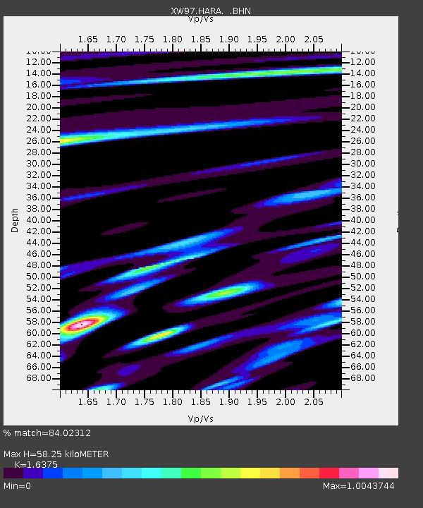
HARA XW.HARA - Earthquake Result Viewer

Earthquake location: Banda Sea
Earthquake latitude/longitude: -7.3/128.5
Earthquake time(UTC): 2000/03/03 (063) 22:09:13 GMT
Earthquake Depth: 142 km
Earthquake Magnitude: 6.4 MB, 5.8 MS, 6.3 MW, 6.3 MW
Earthquake Catalog/Contributor: WHDF/NEIC
Network: XW Tien Shan Continental Dynamics
Station: HARA XW.HARA
Lat/Lon: 40.17 N/76.84 E
Elevation: 1585 m
Distance: 67.0 deg
Az: 319.257 deg
Baz: 122.333 deg
Ray Param: 0.056831438
Estimated Moho Depth: 58.25 km
Estimated Crust Vp/Vs: 1.64
Assumed Crust Vp: 6.491 km/s
Estimated Crust Vs: 3.964 km/s
Estimated Crust Poisson's Ratio: 0.20
Radial Match: 84.02312 %
Radial Bump: 400
Transverse Match: 82.21647 %
Transverse Bump: 400
SOD ConfigId: 20082
Insert Time: 2010-02-26 15:23:16.504 +0000
GWidth: 2.5
Max Bumps: 400
Tol: 0.001

Signal To Noise

ChannelStoNSTALTA
XW:HARA: :BHN:20000303T22:19:20.753013Z7.98573975.753098E-77.204214E-8
XW:HARA: :BHE:20000303T22:19:20.753013Z6.7377711.1756558E-61.7448735E-7
XW:HARA: :BHZ:20000303T22:19:20.753013Z60.9856073.510446E-65.7561877E-8
Arrivals
Ps6.0 SECOND
PpPs23 SECOND
PsPs/PpSs29 SECOND