
Station XW HARA - XW.HARA
Network: XW97 - Tien Shan Continental Dynamics
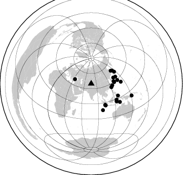
Nearby stations (2 deg radius)
| Station | Name | (Lat, Lon) | Start / End | Elevation |
| HARA | XW.HARA | (40.17, 76.84) | 1999-06-23 / 2002-01-01 | 1585 m |
| Crust2 Type: | R4,orogen/55km Tibet Transition, 0 km seds. |
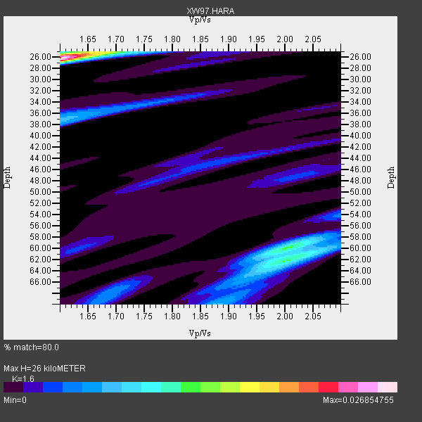
| Thickness Estimate: | 26 km |
| Thickness StdDev: | 12 km |
| Vp/Vs Estimate: | 1.60 |
| Vp/Vs StdDev: | 0.15 |
| Vs Estimate: | 4.057 km/s |
| Poisson's Ratio: | 0.18 |
| Peak Value: | 0.03 |
| Assumed Vp: | 6.491 km/s |
| Ps Weight: | 0.33333334 |
| PpPs Weight: | 0.33333334 |
| PsPs Weight: | 0.33333328 |
| Residual Complexity: | 0.729 |
| Nearby stations H: | +- |
| (2.0 deg) Vp/Vs: | +- |
9 with match > 90% ( 40.909092 %) and 22 with match > 80% ( 100.0 %) out of 22.
Download stack as xyz text file.
Azimuth Distribution of Events:
Prior Results for this Station
| Study | Thickness | Vp/Vs | Vp | Vs | Poissons Ratio | Extra |
| EARS | 26 km | 1.60 | 6.491 km/s | 4.057 km/s | 0.18 | |
| Crust2.0 | 55 km | 1.76 | 6.491 km/s | 3.696 km/s | 0.26 | R4,orogen/55km Tibet Transition, 0 km seds. |
| Global Maxima | 26 km | 1.60 | 6.491 km/s | 4.057 km/s | 0.18 | amp=0.026854755 |
| Local Maxima 1 | 60 km | 2.01 | 6.491 km/s | 3.237 km/s | 0.33 | amp=0.01226605 |
| Local Maxima 2 | 62 km | 2.01 | 6.491 km/s | 3.233 km/s | 0.33 | amp=0.009708917 |
| Local Maxima 3 | 37 km | 1.60 | 6.491 km/s | 4.05 km/s | 0.18 | amp=0.007311771 |
| Local Maxima 4 | 68 km | 1.69 | 6.491 km/s | 3.835 km/s | 0.23 | amp=0.0044399807 |
| Predicted Arrivals for vertical incidence (zero ray parameter) | |
| Ps | 2.40 SECOND |
| PpPs | 10.41 SECOND |
| PsPs/PpSs | 12.82 SECOND |
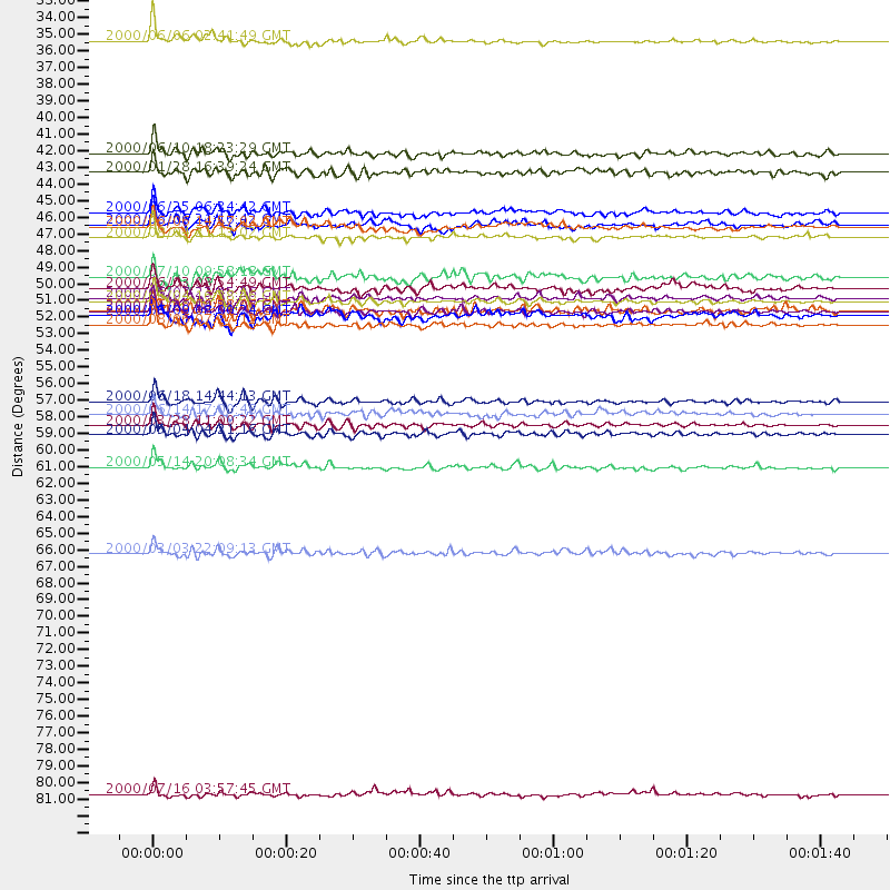
Events Processed for this Station
Download zip of receiver functions as SAC
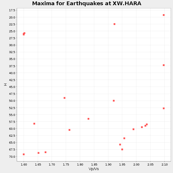
Plot maxima for each earthquake.
Events Used in the Stack
(22 events)| Radial Match | Distance | Baz | FERegion | Time | Lat/Lon | Depth | Magnitude |
| 96.1776 | 58.6 deg | 86.233 deg | Volcano Islands, Japan Region | 2000/03/28 11:00:22 GMT | (22.3, 143.7) | 126 km | 6.8 MB, 7.6 MS, 7.6 MW, 7.6 MW |
| 94.821 | 50.3 deg | 146.482 deg | Southern Sumatra, Indonesia | 2000/06/04 16:28:26 GMT | (-4.7, 102.1) | 33 km | 6.8 MB, 8.0 MS, 7.9 MW, 7.7 MW |
| 93.332695 | 51.0 deg | 62.408 deg | Kuril Islands | 2000/01/28 14:21:07 GMT | (43.0, 146.8) | 61 km | 6.7 MB, 6.6 MS, 6.8 MW, 6.8 ME |
| 92.27994 | 57.0 deg | 155.934 deg | South Indian Ocean | 2000/06/18 14:44:13 GMT | (-13.8, 97.5) | 10 km | 6.8 MB, 7.8 MS, 7.8 MW, 7.6 MW |
| 91.726364 | 51.9 deg | 82.004 deg | Bonin Islands, Japan Region | 2000/08/06 07:27:12 GMT | (28.9, 139.6) | 395 km | 6.3 MB, 7.3 MW, 7.3 MW |
| 91.59507 | 59.2 deg | 122.002 deg | Sulawesi, Indonesia | 2000/05/04 04:21:16 GMT | (-1.1, 123.6) | 26 km | 6.7 MB, 7.5 MS, 7.6 MW, 7.5 ME |
| 91.11802 | 49.5 deg | 73.907 deg | Near East Coast Of Honshu, Japan | 2000/06/03 08:54:49 GMT | (35.6, 140.5) | 62 km | 5.6 MB, 5.6 MS, 6.1 MW, 6.1 MW |
| 91.09162 | 46.1 deg | 56.513 deg | Sakhalin, Russia | 2000/08/04 21:13:02 GMT | (48.8, 142.2) | 10 km | 6.3 MB, 7.1 MS, 6.8 MW, 6.7 MW |
| 90.49276 | 50.2 deg | 146.636 deg | Southern Sumatra, Indonesia | 2000/06/07 23:45:26 GMT | (-4.6, 101.9) | 33 km | 6.1 MB, 6.7 MS, 6.7 MW, 6.5 MW |
| 89.731636 | 61.3 deg | 124.704 deg | Banda Sea | 2000/05/14 20:08:34 GMT | (-4.3, 123.2) | 33 km | 5.9 MB, 5.9 MS, 6.3 MW, 6.2 MW |
| 88.999954 | 44.5 deg | 83.941 deg | Kyushu, Japan | 2000/06/25 06:34:42 GMT | (31.2, 131.2) | 10 km | 5.8 MB, 5.7 MS, 6.2 MW, 5.9 MW |
| 88.153564 | 33.1 deg | 285.418 deg | Turkey | 2000/06/06 02:41:49 GMT | (40.7, 33.0) | 10 km | 5.5 MB, 6.1 MS, 6.1 MW, 6.0 MW |
| 88.129715 | 40.6 deg | 99.96 deg | Taiwan | 2000/06/10 18:23:29 GMT | (23.8, 121.2) | 33 km | 6.2 MB, 6.2 MS, 6.4 MW, 6.3 MW |
| 85.83103 | 51.3 deg | 146.246 deg | Southern Sumatra, Indonesia | 2000/06/09 08:00:24 GMT | (-5.5, 102.7) | 33 km | 5.8 MB, 5.8 MS, 6.0 MW, 6.0 MW |
| 85.72581 | 48.8 deg | 58.225 deg | Sea Of Okhotsk | 2000/07/10 09:58:18 GMT | (46.8, 145.4) | 360 km | 6.1 MB, 5.9 MW, 5.8 MW |
| 84.02312 | 67.0 deg | 122.333 deg | Banda Sea | 2000/03/03 22:09:13 GMT | (-7.3, 128.5) | 142 km | 6.4 MB, 5.8 MS, 6.3 MW, 6.3 MW |
| 82.66985 | 41.8 deg | 94.667 deg | Northeast Of Taiwan | 2000/01/28 16:39:24 GMT | (26.1, 124.5) | 194 km | 6.1 MB, 6.0 MW, 6.0 MW |
| 82.586235 | 50.9 deg | 145.973 deg | Southern Sumatra, Indonesia | 2000/06/06 09:58:06 GMT | (-5.1, 102.7) | 33 km | 5.8 MB, 6.1 MS, 6.2 MW, 6.1 MW |
| 82.22485 | 57.8 deg | 113.968 deg | Talaud Islands, Indonesia | 2000/06/14 17:00:48 GMT | (4.5, 127.7) | 90 km | 6.1 MB, 5.6 MS, 6.4 MW, 6.3 MW |
| 82.12749 | 83.0 deg | 106.222 deg | New Britain Region, P.N.G. | 2000/07/16 03:57:45 GMT | (-7.7, 150.9) | 10 km | 6.3 MB, 6.4 MS, 6.6 MW, 6.6 MW |
| 81.85903 | 45.3 deg | 74.584 deg | Sea Of Japan | 2000/06/06 21:16:42 GMT | (36.8, 135.5) | 10 km | 5.7 MB, 5.3 MS, 5.9 MW, 5.8 MW |
| 80.98893 | 45.5 deg | 86.007 deg | Southeast Of Ryukyu Islands | 2000/06/06 14:57:02 GMT | (29.4, 131.4) | 33 km | 5.8 MB, 6.0 MS, 6.4 MW, 6.4 MW |
Losers
(0 events)| Radial Match | Distance | Baz | FERegion | Time | Lat/Lon | Depth | Magnitude | Reason |
