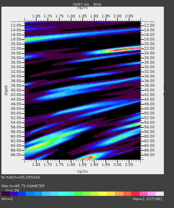
KAI XW.KAI - Earthquake Result Viewer

Earthquake location: Southern Sumatra, Indonesia
Earthquake latitude/longitude: -5.5/102.7
Earthquake time(UTC): 2000/06/09 (161) 08:00:24 GMT
Earthquake Depth: 33 km
Earthquake Magnitude: 5.8 MB, 5.8 MS, 6.0 MW, 6.0 MW
Earthquake Catalog/Contributor: WHDF/NEIC
Network: XW Tien Shan Continental Dynamics
Station: KAI XW.KAI
Lat/Lon: 41.57 N/75.01 E
Elevation: 2016 m
Distance: 53.3 deg
Az: 334.234 deg
Baz: 144.786 deg
Ray Param: 0.06614858
Estimated Moho Depth: 69.75 km
Estimated Crust Vp/Vs: 1.86
Assumed Crust Vp: 6.491 km/s
Estimated Crust Vs: 3.49 km/s
Estimated Crust Poisson's Ratio: 0.30
Radial Match: 85.055046 %
Radial Bump: 400
Transverse Match: 78.9098 %
Transverse Bump: 400
SOD ConfigId: 20082
Insert Time: 2010-02-26 15:24:04.459 +0000
GWidth: 2.5
Max Bumps: 400
Tol: 0.001

Signal To Noise

ChannelStoNSTALTA
XW:KAI: :BHN:20000609T08:09:09.025Z1.7344999.1612506E-85.281785E-8
XW:KAI: :BHE:20000609T08:09:09.025Z0.98755815.6824387E-85.7540298E-8
XW:KAI: :BHZ:20000609T08:09:09.025Z4.5965942.547602E-75.542369E-8
Arrivals
Ps9.7 SECOND
PpPs29 SECOND
PsPs/PpSs39 SECOND